
Dun Garbhlaich


Fort (Prehistoric)
Site Name Dun Garbhlaich
Classification Fort (Prehistoric)
Canmore ID 12375
Site Number NH44NE 5
NGR NH 46604 46572
Datum OSGB36 - NGR
Permalink http://canmore.org.uk/site/12375


- Council Highland
- Parish Kilmorack
- Former Region Highland
- Former District Inverness
- Former County Inverness-shire
NH44NE 5 4662 4660.
(NH 4662 4657) Dun Garbhlaich (NAT) Fort (NR)
OS 6"map,(1957)
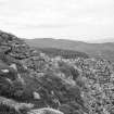
Dun Garbhlaich, a fort, situated on the uneven rocky summit of an isolated crag. It is roughly D-shaped on plan measuring c.35.0m E to W by c. 28.0m transversely with a drystone wall which is completely tumbled on the N and SE, but well preserved in the SW where the outer face stands to a maximum height of c. 1.5m, and the inner face to a maximum height of c. 1.0m giving a wall thickness varying between 3.8m and 2.3m. In the NE the outer face is evident amidst tumble to a maximum height of c.0.8m. The entrance passage, 4.5m long and 1.1m wide is in the S at the easiest point of access and is faced by upright slabs towards the inner end. Within the fort in the E is a ruinous stone-lined well c.3.0m diameter.
The plan by Wallace (T D Wallace 1921) is almost worthless. The outwork shown to the S of the fort is tumble from the main wall.
Depicted at 1/10000 scale.
Planned at 1/1250
Visited by OS (R L) 6 April 1970; Visited by RCAHMS 1957
Field Visit (31 August 1943)
Dun Garbhlaich is perched on a crag about 1030 ft OD that is an isolated SW outlier of the higher and often precipitous ridge of the Urchany & Farley Forest. The core of the site is formed by a ridge of naked rock some 36 ft [11m] wide precipitous on the N and W but sloping away more gently on the uphill NE side to a low col. Some 15 ft below the crest of this rocky spine on the SE is a broad platform some 48 ft [14.6m] wide that again falls away in sheer cliffs on the S & W. Both the ridge crest and the platform are included within the protection of a drystone wall. This runs nearly straight along the edge of the precipice on the N for about 105 ft [32m] but from each end of the spine sweeps out in a rough semi-circle to embrace the level terrace below, running downhill across the slope of naked rock in the SW quadrant. In this segment both inner and outer faces are exposed, 3 ft to 5 ft [0.9m to 1.5m] of almost vertical masonry being visible where the outer face traverses a cleft in the rock. In the S there is an entrance passage 3 ft 8 in [1.1m] wide at its inner end and traceable for 15ft [4.6m] on the W side but 14 ft [4.3m] further W from the inner corner the rampart seems only 11 ft [3.4m] thick. At the foot of the central ridge in the SE quadrant, just within the rampart, is a spring or well that still contained water when visited. Some good sections of outer face neatly adjusted to rock out crops are visible also on the E, but along the cliff edge to the N as well as to the SE the rampart is overgrown with peat and heather.
Visited by RCAHMS (VGC) 31 August 1943.
(T.I.S.S, viii, 119 (plan))
Note (1951 - 1958)
This fort is situated at a height of 1030 feet OD on a rocky eminence that stands up from the higher and broken ground N. of Farley, three- and three-quarter miles W of Beauly. The upper part of the knoll is formed by a ridge of naked rock, the N and W flanks of which are precipitous, while to the NE a gentle slope leads to a col from which the main massif is reached. Some 15 feet below to the SE. is a broad platform the S and W. flanks of which are precipitous. The fort, which encloses both ridge and platform, is D-shaped on plan, measuring 80 feet [24m] in width from E. to W. by 60 [18m] transversely within the ruined stone wall. Sections of both faces are visible, indicating that the wall varies in thickness from 11 feet to 15 feet [3.3m to 4.6m]. The entrance is in the S. A well lies just within the E sector of the wall but the interior is otherwise featureless.
Information from RCAHMS c.1951-8
Field Visit (March 1979)
Dun Garbhlaich NH 466 465 NH44NE 5
This D-shaped fort measures 27m by 23m within a wall up to 3.8m thick which encloses both the summit of a crag and a shelf some 4.5m below on the SE side: considerable portions of wall~face survive where the wall descends to the lower level. The entrance lies on the S.
RCAHMS 1979, visited March 1979
(Wallace 1886, 342-3)
Note (4 March 2015 - 31 May 2016)
This small fort is situated on a rocky hillock rising from a S-facing hillside above Farley. D-shaped on plan, it measures about 35m from ENE to WSW along the chord extending along the crag on the NNW by 28m transversely within a wall from 2.3m to 4.5m in thickness. Long runs of the outer face are visible in the tumbled rubble everywhere except on the NNW, standing up to 1.5m high on the SW, where the inner face also survives to a height of about 1m. The wall is thickest to either side of the entrance, which is on the S; faced with upright slabs, the inner edge of the passage measures 1.1m wide and in 1943 was sketched with checks by RCAHMS investigators, though there is no hint in their description that these were actually visible. Much of the interior is bare rock, but there is what may be a well immediately within the line of the wall on the E.
Information from An Atlas of Hillforts of Great Britain and Ireland – 31 May 2016. Atlas of Hillforts SC2874

