
Following the launch of trove.scot in February 2025 we are now planning the retiral of some of our webservices. Canmore will be switched off on 24th June 2025. Information about the closure can be found on the HES website: Retiral of HES web services | Historic Environment Scotland
Grumby


Cruck Framed Building (Post Medieval), Farmstead (19th Century), Farmstead (Post Medieval), Kiln (Post Medieval)(Possible), Sheepfold (19th Century)(Possible), Stack Yard (19th Century)
Site Name Grumby
Classification Cruck Framed Building (Post Medieval), Farmstead (19th Century), Farmstead (Post Medieval), Kiln (Post Medieval)(Possible), Sheepfold (19th Century)(Possible), Stack Yard (19th Century)
Canmore ID 122689
Site Number NC70NW 133.01
NGR NC 7126 0971
Datum OSGB36 - NGR
Permalink http://canmore.org.uk/site/122689


- Council Highland
- Parish Rogart
- Former Region Highland
- Former District Sutherland
- Former County Sutherland
Field Visit (16 May 1995)
NC70NW 133.01 7126 0971
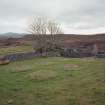
There are two distinct phases of post-medieval settlement at Grumby, the most recent of which was centred on the, now, roofless shell of a building, which was abandoned just after World War II.
The remains of the 19th century farmstead, comprising a dwelling with outshots and a byre, built of faced rubble and standing to wall-head height, are ranged around a stack-yard. The main range of buildings (ROG95 1011) lie along the S side of yard, with at their centre a dwelling with fireplaces in both ends and windows flanking the door on the S side. Three successive phases of outshot have been added on to the W end of the building, all of faced-rubble construction in common with the dwelling. At the E end of the dwelling an outshot, with mortared-rubble walls and a fireplace in the W end, has been added, possibly representing the latest phase of construction. On the W side of the yard there is a byre (ROG95 1010), with a drain emptying out of the door and an outshot to the E. The central portion of the yard has been levelled and supports six stone stack stands measuring up to 3m in diameter and 0.3m in height. There is a sheepfold in the NW corner of the yard. To the S of a dyke which runs along the front of the dwelling there is a midden hollow and a trapezoidal plot, containing some rhubarb plants, which may have been the garden. On the hillside to the W of the farmstead there is a quarry. The main range of buildings and the byre (the W end only, the outshot to E is unroofed) are depicted as roofed on the 1st and 2nd editions of the OS 6-inch map (Sutherland 1879, 1907, sheet xcvi). A further roofed building is shown on the 1st and 2nd edition maps in the NE corner of the yard, of which only a fragment now remains.
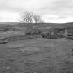
To the W and N of the 19th century farmstead there are the grass-grown footings of an earlier settlement comprising the remains of four buildings (ROG95 1006-8, 1021) and an enclosure. All the buildings are aligned approximately E-W and appear to be of turf-and-stone construction. Considerable disturbance has been caused by turf-stripping to provide capping for the drystone yard of the later farmstead, and some of the buildings may have been ploughed across. Along the N side of the drystone-walled yard there is an L-shaped building (ROG95 1021) which measures 33m by 4m within an earth-and-stone bank spread to 1.5m in thickness and 0.4m in height. Although extensively robbed, it may have had four compartments, with the leg of the L extending to the N from the W end. The eastern compartment is dished and may have been a byre. The other buildings (ROG95 1006-8) are less substantial, measuring internally between 7m and 10.4m in length and 2.5m and 3.5m in breadth. The northern building (ROG95 1006) has been extended by two successive outshots, while a further building (ROG95 1007) has a bed-neuk opening out of the interior. To the E of the farmstead there is a U-shaped hollow measuring 5m by 3.6m and 0.6m in depth which may have been a kiln. The partially removed remains of a turf stell may belong to a more recent use of the site as a sheep farm.
(ROG95 363, 1006-11, 1021)
Visited by RCAHMS (DCC) 16 May 1995
Measured Survey (13 May 1995)
RCAHMS surveyed the farmstead and stack-yard at Grumby with self-reducing alidade and plane-table on 13 May 1995 at a scale of 1:500, with a detail of the long building at 1:100. The resultant plans were redrawn in ink and published at 1:1000 and 1:200 respectively.

