
Upper Morness


Cairnfield (Prehistoric), Rig And Furrow (Medieval) - (Post Medieval)
Site Name Upper Morness
Classification Cairnfield (Prehistoric), Rig And Furrow (Medieval) - (Post Medieval)
Canmore ID 122558
Site Number NC70NW 87
NGR NC 7091 0575
Datum OSGB36 - NGR
Permalink http://canmore.org.uk/site/122558


- Council Highland
- Parish Rogart
- Former Region Highland
- Former District Sutherland
- Former County Sutherland
Field Visit (15 May 1995)
NC70NW 87 7091 0575
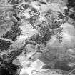
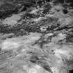
There are at least four small cairns (ROG95 976), measuring up to 5m in diameter and 0.6m in height, on the semi-improved crest of a low ridge to the NW of Upper Morness. Faint traces of ridging (ROG95 1005), measuring about 4m to 5m between furrows, are visible in patches of ground which have been less intensively improved.
(ROG95 976, 1005)
Visited by RCAHMS (DCC) 15 May 1995

