
Dremergid


Cairnfield (Prehistoric), Cord Rig (Prehistoric)
Site Name Dremergid
Classification Cairnfield (Prehistoric), Cord Rig (Prehistoric)
Canmore ID 122424
Site Number NC70NW 18.03
NGR NC 7382 0653
Datum OSGB36 - NGR
Permalink http://canmore.org.uk/site/122424


- Council Highland
- Parish Rogart
- Former Region Highland
- Former District Sutherland
- Former County Sutherland
Field Visit (7 March 1995)
NC70NW 18.03 7382 0653
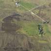
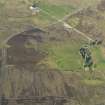
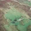
There is a scatter of small cairns, measuring up to 5m in diameter and 0.4m in height, on the crest of the well-drained ridge to the N of Dremergid. Interspersed amongst the cairns, but not forming plots, there are banks or linear clearance heaps, in particular along the break of slope on the SW side of the ridge. The horse-shoe shaped enclosures mentioned by the OS are not plots; they are more likely to be partially destroyed hut-circles (ROG95 5, 6, 9; see NC 70NW 18.01), which have been incorporated into cultivated ground. This is particularly clear in the southernmost structure (ROG95 5), where a third of the circuit of the hut-circle wall has been removed and a swath of cord rig runs into the interior.
The cord rig is visible in areas which suffered from an intense fire about 1980 (information from the crofter at Dremergid), and is most clearly seen around the complex of hut-circles at the centre of the site (see NC 70NW 18.01), where it measures a little over 1m between furrows. This patch of rig is demonstrably later than a shallow ditch around the large central hut-circle (ROG95 3) and may post-date some of the small cairns; as the most ephemeral feature on the site, it is likely also to be the latest. The extent of the survival of cord rig at the S end of the site is determined by the limit of the 19th century ploughing and the more recent improvement of the grassland. Further cord rig is visible on oblique aerial photographs (RCAHMSAP 95) along the ridge to the NNW.
(ROG95 939)
Visited by RCAHMS (DCC) 7 March 1995

