|
Photographs and Off-line Digital Images |
E 61908 CN |
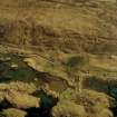
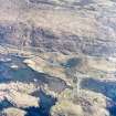
RCAHMS Aerial Photography |
Oblique aerial view centred on the possible enclosure, township, the remains of the buildings and the remains of the dun, taken from the SW. |
23/4/2005 |
Item Level |
|
 |
On-line Digital Images |
SC 1009327 |
RCAHMS Aerial Photography |
Oblique aerial view centred on the possible enclosure, township, the remains of the buildings and the remains of the dun, taken from the SW. |
23/4/2005 |
Item Level |
|
|
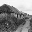
Photographs and Off-line Digital Images |
PA 239/5/2 |
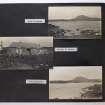
Photographs by Violet Banks, professional photographer, Edinburgh, Scotland |
View of cottage at Strond |
c. 1920 |
Item Level |
|
|
Photographs and Off-line Digital Images |
PA 239/10/1 |
Photographs by Violet Banks, professional photographer, Edinburgh, Scotland |
View of cottages at Strond |
c. 1920 |
Item Level |
|
 |
On-line Digital Images |
SC 1114998 |
Photographs by Violet Banks, professional photographer, Edinburgh, Scotland |
View of cottages at Strond. |
c. 1920 |
Item Level |
|
 |
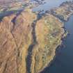
On-line Digital Images |
DP 110643 |
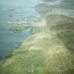
RCAHMS Aerial Photography Digital |
General oblique aerial view of the remains of the townships of Strond, Carminish and Borosdale and the nearby head dyke and lazy beds, Leverburgh, Harris, taken from the NW. |
14/11/2011 |
Item Level |
|
 |
On-line Digital Images |
DP 110644 |
RCAHMS Aerial Photography Digital |
General oblique aerial view of the remains of the townships of Strond, Carminish and Borosdale and the nearby head dyke and lazy beds, Leverburgh, Harris, taken from the NW. |
14/11/2011 |
Item Level |
|
 |
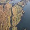
On-line Digital Images |
SC 1694700 |
RCAHMS Aerial Photography |
Oblique aerial view centred on the possible enclosure, township, the remains of the buildings and the remains of the dun, taken from the SW. |
23/4/2005 |
Item Level |
|
 |
On-line Digital Images |
SC 1967242 |
Papers of James Sloan Bone, landscape historian, Inverness, Highland, Scotland |
Aerial view of Strond/Srannda, Carminish & Leverburgh, South Harris, Hebrides, looking NW. |
6/1985 |
Item Level |
|
 |
On-line Digital Images |
DP 391086 |
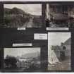
Photographs by Violet Banks, professional photographer, Edinburgh, Scotland |
Violet Banks Photograph Album - Isle of Harris - Page 5 - Loch Steisevat |
c. 1920 |
Item Level |
|
 |
On-line Digital Images |
DP 391091 |
Photographs by Violet Banks, professional photographer, Edinburgh, Scotland |
Violet Banks Photograph Album - Isle of Harris - Page 10 - Northton woman; Leverburgh woman |
c. 1920 |
Item Level |
|


