
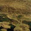
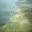
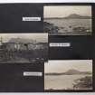
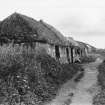
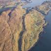
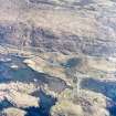
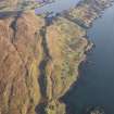
Harris, Strond


Head Dyke (Post Medieval), School (Period Unassigned), Township (Period Unassigned)
Site Name Harris, Strond
Classification Head Dyke (Post Medieval), School (Period Unassigned), Township (Period Unassigned)
Alternative Name(s) Carminish
Canmore ID 122312
Site Number NG08SW 12
NGR NG 030 842
NGR Description Centred NG 030 842
Datum OSGB36 - NGR
Permalink http://canmore.org.uk/site/122312


- Council Western Isles
- Parish Harris
- Former Region Western Isles Islands Area
- Former District Western Isles
- Former County Inverness-shire
Note
A township comprising forty-four roofed buildings, including a school, four partially roofed buildings, eight unroofed buildings, several enclosures and a head-dyke is depicted on the 1st edition of the OS 6-inch map (Inverness-shire, Island of Harris 1882, sheet xxii). Thirty roofed, two partially roofed, sixteen unroofed buildings, several enclosures and a head-dyke are shown on the current edition of the OS 1:10000 map (1973).
Information from RCAHMS (SAH) 18 March 1997.

