
Harris, Leverburgh, Obbe


Head Dyke (Post Medieval), School (Period Unassigned), Smithy (Period Unassigned), Township (Period Unassigned), Township (Period Unassigned)
Site Name Harris, Leverburgh, Obbe
Classification Head Dyke (Post Medieval), School (Period Unassigned), Smithy (Period Unassigned), Township (Period Unassigned), Township (Period Unassigned)
Canmore ID 122309
Site Number NG08NW 5
NGR NG 023 865
NGR Description centred on NG 023 865
Datum OSGB36 - NGR
Permalink http://canmore.org.uk/site/122309


- Council Western Isles
- Parish Harris
- Former Region Western Isles Islands Area
- Former District Western Isles
- Former County Inverness-shire
Note
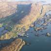
A township and a crofting township are depicted on the 1st edition of the OS 6-inch map (Inverness-shire, Island of Harris 1882, sheet xxii). The township (NG 014 865) comprises eight roofed, one partially roofed, three unroofed buildings and two enclosures. The crofting township comprises twenty-one roofed buildings, which include a school and a smithy, two partially roofed buildings, seven unroofed buildings and several enclosures. A head-dyke is also depicted.
This site is located within the modern towns of Leverburgh and Obbe as shown on the current edition of the OS 1:10000 map (1974).
Information from RCAHMS (SAH) 18 March 1997

