|
Prints and Drawings |
RCD 31/2 |
|
"Elevation, plan and dimensions of bridges in the Highlands of Scotland, made and constructed under the direction of the Commissioners for Highland roads and bridges 1803-1821"
Thomas Telford, engineer; Engraved by Edmund Turrell; Drawn by R H Palmer
Covers the following bridges: Bridge at Greystones, Latheran Wheel Bridge, Balnagown Bridge, Allness Bridge, Easter Fearn, Bridge over the Varrar, Cannech Bridge, Bridge over the Diak, Bridge for the Aultmore, Sheal Bridge, Cros Bridge, Bridge over the river Moriston, Borlam Bridge, Bridge of Ballachandraine, Adrie Bridge, Calder Bridge, Kirk Laggan Bridge, Bridge for the Water of Roy, Spean Bridge, Bonar Bridge over the Dornoch Firth, Contin Bridge, Craig Ellachie, Alford Bridge over the river Don, Wick Bridge, Helmsdale Bridge, Aultnaharrar Bridge over the Tarrie, Conan Bridge, Dunkeld Bridge over the river Tay, Lovat Bridge, Potarch Bridge over river Dee, Torgoyle Bridge, Balater Bridge over river Dee, Strathfleet Mound and Bridge, Fairness Bridge, Bridge and river Nethy.
|
1821 |
Item Level |
|
|
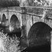
Photographs and Off-line Digital Images |
A 82464 |
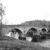
Dr Joanna Close-Brooks |
View from north |
1985 |
Item Level |
|
|
Photographs and Off-line Digital Images |
A 82465 |
Dr Joanna Close-Brooks |
View from north |
1985 |
Item Level |
|
|
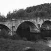
Photographs and Off-line Digital Images |
A 82466 |
Dr Joanna Close-Brooks |
View from south |
1985 |
Item Level |
|
|
Photographs and Off-line Digital Images |
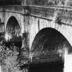
A 14060 |
|
General view from east |
1985 |
Item Level |
|
|
Photographs and Off-line Digital Images |
A 14059 |
|
General view from east |
1985 |
Item Level |
|
|
Photographs and Off-line Digital Images |
A 14058 |
|
General view from east |
1985 |
Item Level |
|
|
Photographs and Off-line Digital Images |
A 14057 |
|
General view from south west |
1985 |
Item Level |
|
|
Photographs and Off-line Digital Images |
A 14056 |
|
General view from south |
1985 |
Item Level |
|
|
Photographs and Off-line Digital Images |
A 14055 |
|
Distant view from south west |
1985 |
Item Level |
|
|
Photographs and Off-line Digital Images |
A 14054 |
|
View from west |
1985 |
Item Level |
|
|
Photographs and Off-line Digital Images |
A 14143 CS |
|
General view |
1985 |
Item Level |
|
|
Photographs and Off-line Digital Images |
A 14144 CS |
|
General view |
1985 |
Item Level |
|
|
Photographs and Off-line Digital Images |
A 14145 CS |
|
General view |
1985 |
Item Level |
|
|
Photographs and Off-line Digital Images |
A 14146 CS |
|
General view |
1985 |
Item Level |
|
 |
On-line Digital Images |
SC 495897 |
Papers of Professor John R Hume, economic and industrial historian, Glasgow, Scotland |
Torgyle Bridge
General View |
26/5/1976 |
Item Level |
|
|
Manuscripts |
MS 749/2332 |
Papers of Professor John R Hume, economic and industrial historian, Glasgow, Scotland |
J R Hume Industrial/CBA cards. Filed under Inverness-shire county, Urquhart and Glenmoriston parish, Road Bridge. Photograph noted. (See NMRS MS/749 entyr for Collection description) |
|
Item Level |
|
 |
On-line Digital Images |
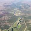
DP 111920 |
RCAHMS Aerial Photography Digital |
General oblique aerial view of the remains of the Fort Augustus-Bernera military road along Glen Moriston near Dalchreichart, taken from the SSE. |
1/5/2011 |
Item Level |
|
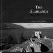 |
Digital Files (Non-image) |
WP 003886 |
Publications by the Royal Commission on the Ancient and Historical Monuments of Scotland |
Exploring Scotland's Heritage: The Highlands |
1995 |
Item Level |
|
 |
On-line Digital Images |
SC 1923860 |
Dr Joanna Close-Brooks |
View from north |
1985 |
Item Level |
|
 |
On-line Digital Images |
SC 1923861 |
Dr Joanna Close-Brooks |
View from north |
1985 |
Item Level |
|
 |
On-line Digital Images |
SC 1923862 |
Dr Joanna Close-Brooks |
View from south |
1985 |
Item Level |
|
 |
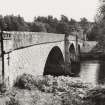
On-line Digital Images |
SC 2361413 |
Records of the Ordnance Survey, Southampton, Hampshire, England |
Torgyle Bridge, NH31SW 1, Ordnance Survey index card, Recto |
1958 |
Item Level |
|
 |
On-line Digital Images |
SC 2562007 |
|
View from west |
1985 |
Item Level |
|


