
Invergarry Castle


Castle (Medieval)
Site Name Invergarry Castle
Classification Castle (Medieval)
Alternative Name(s) Invergarry, Glengarry Castle
Canmore ID 12217
Site Number NH30SW 2
NGR NH 31491 00612
Datum OSGB36 - NGR
Permalink http://canmore.org.uk/site/12217


- Council Highland
- Parish Kilmonivaig
- Former Region Highland
- Former District Lochaber
- Former County Inverness-shire
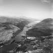
Invergarry Castle, 17th century 'Glengaries new House' (wall thicknesses suggest the reworking of an earlier building), burned and 'defaced' by General Monk in 1654, restored by mason Robert Nicholson c.1670, but again damaged and then repaired after the 1715 and 1745 uprisings. Rising above Loch Oich sheer from Creagan an Fhithich (Raven's Rock - the Macdonells' war cry), this lofty, L-plan 'extraordinary strong house - fortified and cannot be taken without great cannon' had a martial presence that belied its internal splendour. A regal stairway rose in the (now largely destroyed) west jamb to the principal floor, at which level the entire (unvaulted) main range was occupied by a colonnaded apartment overlooking the river, with circular 'privy' stair tower on the north-east corner; guest chambers above the principal stair. In the angle, a six-storey square stair tower and a turret stair served the upper floors.
[In the 1690s Invergarry Castle was at the mercy of garrisoning Government troops (as were Tioram and other strongholds in the area), with Glengarry petitioning unsuccessfully in 1704 for the return of his home and compensation for damage done by the 'disorderly carriage of the souldiers'. In 1715 he overpowered the outstation at Invergarry, but in 1716 the castle was again seized and accidentally burned following the Jacobite uprising, In 1727, Thomas Rawlinson, an iron master of the York Buildings Co, did up the dilapidated structure for his residence, but was later expelled by Glengarry, who disliked seeing a Sassanach occupying his home and took up residence here again in 1731. BPC stayed here before and after Culloden and it was destroyed by Cumberland in 1746.]
Taken from "Western Seaboard: An Illustrated Architectural Guide", by Mary Miers, 2008. Published by the Rutland Press http://www.rias.org.uk

NH30SW 2 31491 00612.
(NH 3150063) Invergarry Castle (A.T) (Remains of)
Invergarry Castle was a stronghold of the Macdonnels and was occupied by the chief of that clan until 1746 when it was destroyed by the Duke of Cumberland. The existing building, on the L-plan seems to date from the end of the 17th century. The main building measures about 55 feet by 32 feet over the walls, which have been carried to a height of five stories. The wing which was on the west or landward side has been almost entirely demolished, but enough remains to enable the plan to be traced. The building is now ruinous.
j MacGibbon and J Ross 1889
Invergarry Castle, is as described above.
Visited by OS (R B) 8 May 1964
REFERENCE
On the Estate of Invergarry, in the Parish of Kilmonivaig, Inverness-shire, near the Western shore of Loch Oich, and seven and a half miles S.W. of Fort Augustus. As stated in Groome's Ordnance Gazetteer, 1901, the 'ruined' Castle stands half a mile South of the hamlet of Invergarry.
Among Military Maps and Drawings (of the 18th Century) of the Board of Ordnance, Reference "MSS. 1645-1652" in the Index of the National Library of Scotland, is a Drawing contained in Volume or Case No. 1648 and numbered.-
Z.3/27. A "Plann, (to scale of 20 Feet to an Inch), and Prospects (or views) of the Castle of Glengarry", surveyed and deliver'd by Lewis Petit.. There is no date, but there is a copy of same dated 1741.
Macgibbon and Ross, in "The Castellated and Domestic Architecture of Scotland" refer to "Invergarry Castle" on the thickly wooded and precipitous North bank of Loch Oich. It was the stronghold of the Macdonnels, and was occupied by the cief of the Clan till 1746, when it was burned and detroyed by the Duke of Cumberland. They give a Plan and two pen and ink views.
REFERENCE
National Library Nattes Drawings, Vol 2, No. 70. 22nd Sept - 1 drawing.
Standing Building Recording (November 2006 - November 2007)
NH 31491 00612 Consolidation of the late 16th- to early 17th century Invergarry Castle was begun in November 2006 and is nearing completion in November 2007. The roofless castle stands in part to five storeys in height. It is of L-plan, though the wing at the S W corner was largely destroyed after the 1745 uprising, while the adjacent stair tower collapsed in the early 1990s. There is a further round stair tower at the NE corner.
Though no groundworks have been necessary, a watching brief has been maintained throughout the consolidation works and a comprehensive photographic and written record of the building compiled.
Funder: Historic Scotland, Mr and Mrs McCallum.

