
Stirling, Causewayhead Road, New Bridge


Road Bridge (19th Century)
Site Name Stirling, Causewayhead Road, New Bridge
Classification Road Bridge (19th Century)
Alternative Name(s) River Forth; William Iv Bridge
Canmore ID 121536
Site Number NS79SE 185
NGR NS 79737 94464
Datum OSGB36 - NGR
Permalink http://canmore.org.uk/site/121536


- Council Stirling
- Parish Stirling
- Former Region Central
- Former District Stirling
- Former County Stirlingshire
NS79SE 185 79737 94464
Location formerly cited as NS 79742 94466, and as NS 7969 9444 to NS 7979 9449
For predecessor bridges, see NS79SE 1 and NS79SE 2.
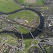
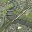
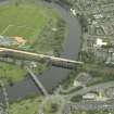
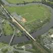
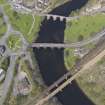
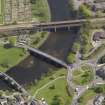
(Location cited as NS 797 944). New Bridge, built 1831, engineer Robert Stevenson. A five-span bridge of rustic ashlar construction with segmental arches and rounded cutwaters. The courses of the spandrels follow the lines of the voussoirs.
J R Hume 1976.
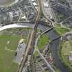
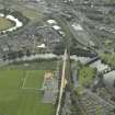
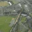
This bridge carries Causewayhead Road (which here forms the A9) across the River Forth to the N of Stirling (NS79SE 154). It is depicted, but not noted, on the 1982 edition of the OS 1:10,000 map.
The location assigned to this record defines the mispoint of the structure. The available map evidence suggests that it extends from NS c. 79790 94490 to c. 79689 94440.
Information from RCAHMS (RJCM), 30 September 1997.
EXTERNAL REFERENCE:
Scottish Record Office
Ceremony of Laying the Foundation Stone of Stirling Bridge, 8th September 1831.
Programme.
A note adds that to prevent accidents, no spectators will be allowed on the Old Bridge.
1831 GD 189/6/10
Building the New Bridge.
'...what of the parapet has been done looks pretty well and has a neat appearance.
I still think, however, that a cope stone projecting more at both sides would
have looked more massy and finished like and have been more in tone with the
massive moulding below and also with the several rustic expressions of the
outer face..'
Letter from James Smith to William Murray of Polmaise.
1833 GD 189/2/741
Proposed new bridge at Stirling.
Copy of Minutes of a General Meeting of the County of Stirling and a copy of
Minutes of the Committe on the new bridge.
1823 GD 189/6/8
(Undated) information in NMRS.
Project (2007)
This project was undertaken to input site information listed in 'Civil engineering heritage: Scotland - Lowlands and Borders' by R Paxton and J Shipway, 2007.
Publication Account (2007)
The elegant William IV or ‘New’ Bridge, Stirling was built from 1829–32 to the design of Robert Stevenson, was the most seaward road crossing of the Forth for more than a century until Kincardine Bridge was opened.
The bridge, now carrying the A9, has five segmental masonry arch spans ranging from 5312 ft–65 ft with radially oriented masonry in the spandrel faces. The foundation stone was laid in March 1831 and every arch-stone, which increased in depth from the crown towards the springing, was numbered as a guide to its position in the finished work. Stevenson’s son David helped to dress at least one of the greenstone archstones.
Someof the foundationswere built on platforms on timber piles. The contractorwas Keith Mathieson of Stirling and the Resident Inspector was George Middlemiss who had just finished acting in a similar capacity atMontrose Suspension Bridge for Capt. S. Brown. The cost was about £17 000.
R Paxton and J Shipway 2007
Reproduced from 'Civil Engineering heritage: Scotland - Lowlands and Borders' with kind permission from Thomas Telford Publishers.

