
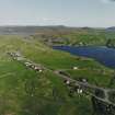
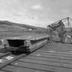
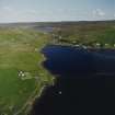
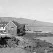
Voe, Fishing Station, Jetty


Jetty (Period Unassigned), Pier (Period Unassigned), Tramway (Modern)
Site Name Voe, Fishing Station, Jetty
Classification Jetty (Period Unassigned), Pier (Period Unassigned), Tramway (Modern)
Alternative Name(s) Pier
Canmore ID 1214
Site Number HU46SW 7.01
NGR HU 40602 63186
Datum OSGB36 - NGR
Permalink http://canmore.org.uk/site/1214


- Council Shetland Islands
- Parish Delting
- Former Region Shetland Islands Area
- Former District Shetland
- Former County Shetland
HU46SW 7 40602 63186
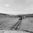
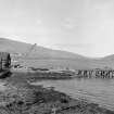
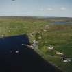
(Location cited as HU 406 632). Pier, Voe, 19th or 20th century. A small rubble pier with a wood-piled extension. There is a short 16ins (0.4m) gauge tramway on the wooden part for the movement of fish to a corrugated-iron processing plant at the pierhead.
J R Hume 1977.

