|
Manuscripts |
MS 2028 |
Records of CFA Archaeology Ltd, archaeologists, Musselburgh, East Lothian, Scotland |
Report: 'A832 Achnasheen to Kinlochewe Road Upgrade. Phase 2: Lubmore to Glen Docherty Viewpoint. Archaeological Recording and Excavations. Data Structure Report' |
5/2004 |
Item Level |
|
 |
On-line Digital Images |
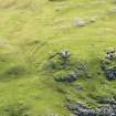
DP 260429 |
Historic Environment Scotland |
Oblique aerial view. |
25/8/2017 |
Item Level |
|
 |
On-line Digital Images |
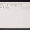
SC 2361099 |
Records of the Ordnance Survey, Southampton, Hampshire, England |
Loch A' Chroisg, NH05NE 2, Ordnance Survey index card, Recto |
c. 1958 |
Item Level |
|
 |
On-line Digital Images |
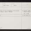
SC 2361100 |
Records of the Ordnance Survey, Southampton, Hampshire, England |
Loch A' Chroisg, NH05NE 2, Ordnance Survey index card, page number 1, Recto |
c. 1958 |
Item Level |
|
|
All Other |
551 166/1/1 |
Records of the Ordnance Survey, Southampton, Hampshire, England |
Archaeological site card index ('495' cards) |
1947 |
Sub-Group Level |
|


