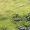
Accessibility

Font Size

100% 150% 200%

Background Colour

Default Contrast
Close Reset

Loch A' Chroisg

Iron Working Site (17th Century)

Site Name Loch A' Chroisg

Classification Iron Working Site (17th Century)

Canmore ID 12079

Site Number NH05NE 2

NGR NH 09 58

Datum OSGB36 - NGR

Permalink http://canmore.org.uk/site/12079

Ordnance Survey licence number AC0000807262. All rights reserved.
Canmore Disclaimer. © Bluesky International Limited 2025. Public Sector Viewing Terms

Toggle Aerial | View on large map

Digital Images

Loch A' Chroisg, NH05NE 2, Ordnance Survey index card, Recto
Loch A' Chroisg, NH05NE 2, Ordnance Survey index card, RectoLoch A' Chroisg, NH05NE 2, Ordnance Survey index card, page number 1, RectoOblique aerial view.

Administrative Areas

  • Council Highland
  • Parish Contin
  • Former Region Highland
  • Former District Ross And Cromarty
  • Former County Ross And Cromarty

Archaeology Notes

NH05NE 2 09 58.

There are traces of old iron-workings at the western end of Loch Rosque (Loch a' Chroisg)

J H Dixon 1886

Not located

Visited by OS (N K B) 26 October 1966

References

MyCanmore Image Contributions


Contribute an Image

MyCanmore Text Contributions