
Sandhaven, Harbour


Defence Obstruction(S) (Second World War), Harbour (19th Century)
Site Name Sandhaven, Harbour
Classification Defence Obstruction(S) (Second World War), Harbour (19th Century)
Alternative Name(s) Sandhaven Harbour; North Sea
Canmore ID 120168
Site Number NJ96NE 31
NGR NJ 9670 6740
NGR Description Centred NJ 9670 6740
Datum OSGB36 - NGR
Permalink http://canmore.org.uk/site/120168


- Council Aberdeenshire
- Parish Pitsligo
- Former Region Grampian
- Former District Banff And Buchan
- Former County Aberdeenshire
NJ96NE 31 centred 9670 6740
Harbour (disused) [NAT]
OS 1:10,000 map, 1985.
For Sandhaven, Main Street, Forbes' Boatyard (NJ 964 674), see NJ96NE 28.
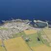
(Location cited as NJ 967 673). Sandhaven Harbour, built 1840 and subsequently extended (c. 1873), engineers James F Beattie & Son, Aberdeen. A large basin formed a long L-plan pier and a short straight pier, with a subdividing straight pier. Most of the works are in concrete, and are badly decayed. There is a boatbuilding yard (NJ96NE 28) at the W end of the harbour.
J R Hume 1977.
Air photographs: AAS/97/12/G25/23-4 and AAS/97/12/CT.
NMRS, MS/712/29.
Oblique aerial photographs taken during World War II (RAF S319.H53.1416, frame nos.53-5, flown 11 July 1941), show that both breakwaters had their landward ends obstructed by brick and concrete walls standing to about 4m in height.
Information from RCAHMS (DE), August 1941.
Note (21 January 2021)
Both outer breakwaters and the inner jetty had walls built across them during the Second World War at NJ 96562 67509, NJ 96590 67466 and still extant NJ 96837 67299. All three are visible on RAF oblique air photograph M/120/S319 0053 and 0055 (flown 11 July 1941).
Information from Pillbox Study Group and HES (AKK) 21 January 2021
Field Visit (September 2022)
NJ 96700 67400 Visited during fieldwork by SCAPE. No changes to description. Harbour has visible signs of decay, especially on the pier of the larger harbour extension.
Information from S. Boyd and J. Hambly - Scottish Coastal Archaeology and the Problem of Erosion (SCAPE)

