
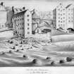
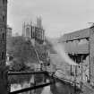
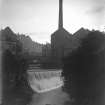
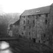
Edinburgh, Dean, Miller Row, Lindsay's Mill


Grain Mill (Period Unassigned)
Site Name Edinburgh, Dean, Miller Row, Lindsay's Mill
Classification Grain Mill (Period Unassigned)
Alternative Name(s) Dean Village Distillery; Bell's Brae
Canmore ID 120092
Site Number NT27SW 698
NGR NT 24166 73949
Datum OSGB36 - NGR
Permalink http://canmore.org.uk/site/120092


- Council Edinburgh, City Of
- Parish Edinburgh (Edinburgh, City Of)
- Former Region Lothian
- Former District City Of Edinburgh
- Former County Midlothian
Lindsay's Mill demolished 1931
Publication Account (1951)
In the masonry at the S. end of the bridge [NT27SW 676] crossing the Water of Leith at the foot of Bell's Brae are inserted two stones recently removed from Lindsay's Mill [NT27SW 698]. On the first is a panel displaying the date 1643 and two bakers' peels in saltire, each bearing three cakes. The second is a window lintel inscribed BLESIT BE GOD FOR AL HIS GIFTIS.
RCAHMS 1951, visited c.1941
Standing Building Recording (4 November 2015 - 27 April 2018)
Archaeological monitoring works and Building insepction were undertaken over five intermittent stages commencing on the 4th November 2015 and finishing on the 27th April 2018 on behalf of Sundial Properties. This Data Structure Report covers the monitoring works and building inspection requested by City of Edinburgh Council Archaeology Service who advise the City of Edinburgh Council on archaeological matters.
In the course of the archaeological monitoring no significant archaeology was uncovered. All layers and deposits recorded were indicative of heavily disturbed areas that have been subject to a number changes over the period in which the area has been in use.
Information from Peter Kleman (Rathmell Archaeology Ltd) 1 May 2018. OASIS ID: rathmell1-240711

