
Forth Defences, Outer, Leith Docks Battery


Coastal Battery (Second World War), Coastal Battery (First World War)
Site Name Forth Defences, Outer, Leith Docks Battery
Classification Coastal Battery (Second World War), Coastal Battery (First World War)
Alternative Name(s) Black Rock Battery; Black Rocks; Forth Defences; Imperial Dock; Firth Of Forth; Outer Forth Estuary
Canmore ID 120061
Site Number NT27NE 162
NGR NT 2785 7710
NGR Description Centred NT 2785 7710
Datum OSGB36 - NGR
Permalink http://canmore.org.uk/site/120061

- Council Edinburgh, City Of
- Parish Edinburgh (Edinburgh, City Of)
- Former Region Lothian
- Former District City Of Edinburgh
- Former County Midlothian
The battery at Leith docks was positioned at the southern end of the Outer Defences of the Firth of Forth in the First World War. The battery was situated at the corner of the sea wall close to the Imperial Dock (as it was then - the land area has since been extended into the sea). It was built in 1916-17 and comprised two emplacements for 6-inch Breech Loading guns with, to the west, a combined Battery Command Post and station for the Electric Light Director, a building with three storeys, and to the south, a blockhouse. The guns were moved here from Hound Point, further up-river. The Defence Electric Lights - powerful searchlights intended to illuminate targets for the guns at night - were situated further to the west along the seawall, at NT 27367 77336 and NT 27160 77471. The engine house to power the lights was built between the lights and a little inland, at NT 27267 77375. The battery’s guns and lights were recorded in the definitive survey of the Forth’s defences dated October 1916, on War Office file (The National Archives WO 78/ 5179). They covered the channel between Leith and the island of Inchkeith, which was obstructed by a submarine net. The battery was provided with two machine-guns for close defence. The accommodation for the men was built in a small compound to the south, at NT 27607 77009, shown a map in War Office file (The National Archives WO 78/4396).
The battery continued in use through the Second World War and was demolished in the 1950s. An undated map of the Leith Battery on the Fort Record Book for the Coastguard Battery at North Queensferry [WO 192/104] shows the Leith Battery, its DELs and accommodation at the DEL engine house - this may date from the Second World War period.
Information from HS/RCAHMS World War One Audit Project (GJB) 13 August 2013.
NT27NE 162 centred 2785 7710
See also NT27NE 57.00 and NT27NE 57.04 .
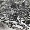
Leith Docks battery was situated on the outer face of the Imperial Dock (NT27NE 57.04), at a point where the sea wall changes angle. The battery consisted of two guns with ancillary support buildings. The battery is visible on a vertical air photograph taken during the war (RAF 614.J.SHT 775987, 1035, flown 1941) and is also just visible on an oblique photograph RAF 614.D.SHT.68.1 775987, 1500, flown 1941) and the remains are visible on a post-war vertical air photograph (RAF 106G/Scot/UK/118, 6002, flown 1946).
Information from RCAHMS (DE) August 1997
This coast battery has been demolished, but was located slightly inland of the present outer sea wall.
The construction of the battery was approved in 1915 and approval was given to tranfer two 6-inch guns (numbered 1335 and 1345) on CP II mountings from Hound Point (NT17NE 70). One gun was installed in September, the other in October 1916. In addition two Maxim .303 guns on tripod mountings were installed in October 1917.
The position was known as Black Rock Battery and closed in 1955, the guns having been removed in 1953.
J A Guy 1997; NMRS MS 810/5, 98-100; PRO WO/192/252.
Project (March 2013 - September 2013)
A project to characterise the quantity and quality of the Scottish resource of known surviving remains of the First World War. Carried out in partnership between Historic Scotland and RCAHMS.

