
Pricing Change
New pricing for orders of material from this site will come into place shortly. Charges for supply of digital images, digitisation on demand, prints and licensing will be altered.
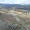
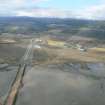
Evanton Airfield


Bomb Store (20th Century)
Site Name Evanton Airfield
Classification Bomb Store (20th Century)
Alternative Name(s) Novar Camp
Canmore ID 119796
Site Number NH66NW 34.10
NGR NH 6170 6640
Datum OSGB36 - NGR
Permalink http://canmore.org.uk/site/119796


- Council Highland
- Parish Kiltearn
- Former Region Highland
- Former District Ross And Cromarty
- Former County Ross And Cromarty
NH66NW 34.10 Centred 6170 6640
The bomb store for Evanton Airfield has been destroyed by the construction of the oil pipeline construction yard and the new section of the A9 trunk road, little trace survives.
The bomb store is visible on vertical air photograph (RAF 106G/Scot/UK 114, 3098, flown 1946) and is also shown on a plan of the airfield held in the RAF Archives.
Visited by RCAHMS (DE) May 1997

