 |
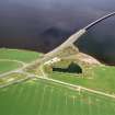
On-line Digital Images |
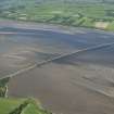
SC 1012414 |
Records of Aberdeen Aerial Surveys, Aberdeen, Scotland |
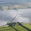
Oblique aerial view centred on the Cromarty Bridge, looking to the NNW. |
24/8/1979 |
Item Level |
|
 |
On-line Digital Images |
DP 024082 |
RCAHMS Aerial Photography Digital |
Oblique aerial view centred on the road bridge, taken from the SE. |
3/4/2007 |
Item Level |
|
 |
On-line Digital Images |
DP 024083 |
RCAHMS Aerial Photography Digital |
Oblique aerial view centred on the road bridge, taken from the ESE. |
3/4/2007 |
Item Level |
|
 |
On-line Digital Images |
DP 024085 |
RCAHMS Aerial Photography Digital |
Oblique aerial view centred on the road bridge, taken from the SW. |
3/4/2007 |
Item Level |
|
 |
On-line Digital Images |
DP 024086 |
RCAHMS Aerial Photography Digital |
Oblique aerial view centred on the road bridge, taken from the NE. |
3/4/2007 |
Item Level |
|
 |
On-line Digital Images |
DP 024087 |
RCAHMS Aerial Photography Digital |
Oblique aerial view centred on the road bridge, taken from the NNW. |
3/4/2007 |
Item Level |
|
 |
On-line Digital Images |
DP 024088 |
RCAHMS Aerial Photography Digital |
Oblique aerial view centred on the road bridge, taken from the NW. |
3/4/2007 |
Item Level |
|
|
Manuscripts |
MS 2776/1/9 |
Historic Scotland Archive Project |
Survey archive: Site record sheets, site record sheets with field notes and monument forms from the Inner Moray Firth (Moray, Beauly and Cromarty Firth) Coastal Assessment Survey. Sheet 9. |
9/1998 |
Item Level |
|
|
Photographs and Off-line Digital Images |
H 92917 CS |
RCAHMS Aerial Photography |
General oblique aerial view of the Cromarty Firth centred on the road bridge, taken from the NE. |
2/8/1991 |
Item Level |
|
|
Prints and Drawings |
BD 104/1/9 |
Historic Scotland Archive Project |
Survey archive: 1:25,000 OS Pathfinder map depicting site locations from the Moray, Beauly and Cromarty Firth Coastal Assessment Survey. Sheet 9. |
9/1998 |
Item Level |
|
 |
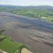
On-line Digital Images |
DP 093611 |
RCAHMS Aerial Photography Digital |
General oblique aerial view of the Cromarty Bridge with Ardullie Lodge in the foreground, looking SSE. |
24/7/2010 |
Item Level |
|
 |
On-line Digital Images |
DP 191595 |
RCAHMS Aerial Photography Digital |
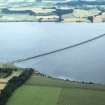
Oblique aerial view of Cromarty Bridge, looking W. |
18/6/2014 |
Item Level |
|
 |
On-line Digital Images |
DP 191596 |
RCAHMS Aerial Photography Digital |
General oblique aerial view of the Cromarty Bridge, looking WSW. |
18/6/2014 |
Item Level |
|
 |
On-line Digital Images |
DP 191597 |
RCAHMS Aerial Photography Digital |
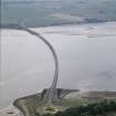
General oblique aerial view of the Cromarty Bridge, looking SW. |
18/6/2014 |
Item Level |
|
 |
On-line Digital Images |
DP 191598 |
RCAHMS Aerial Photography Digital |
general olique aerial view of the Cromarty Bridge, looking SW. |
18/6/2014 |
Item Level |
|
 |
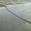
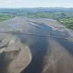
On-line Digital Images |
DP 191607 |
RCAHMS Aerial Photography Digital |
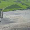
Oblique aerial view of the fish traps, looking SSE. |
18/6/2014 |
Item Level |
|
 |
On-line Digital Images |
DP 191608 |
RCAHMS Aerial Photography Digital |
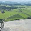
General oblique aerial view of the fish traps, looking SSE. |
18/6/2014 |
Item Level |
|
|
Photographs and Off-line Digital Images |
J 11933 CS |
Papers of Professor Geraint Dyfed Barri Jones, archaeologist, Manchester, England |
General view of Ardullie Point and the Cromarty Bridge |
c. 1991 |
Item Level |
|
|
Photographs and Off-line Digital Images |
J 11934 CS |
Papers of Professor Geraint Dyfed Barri Jones, archaeologist, Manchester, England |
General view of Ardullie Point and the Cromarty Bridge |
c. 1991 |
Item Level |
|
 |
On-line Digital Images |
SC 1590139 |
Papers of Professor Geraint Dyfed Barri Jones, archaeologist, Manchester, England |
General view of Ardullie Point and the Cromarty Bridge |
c. 1991 |
Item Level |
|
 |
On-line Digital Images |
SC 1590140 |
Papers of Professor Geraint Dyfed Barri Jones, archaeologist, Manchester, England |
General view of Ardullie Point and the Cromarty Bridge |
c. 1991 |
Item Level |
|
 |
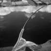
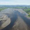
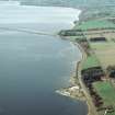
On-line Digital Images |
SC 1906876 |
Papers of James Sloan Bone, landscape historian, Inverness, Highland, Scotland |
Aerial view of South side of the Cromarty Bridge, looking over the Cromarty Firth, looking W. |
2000 |
Item Level |
|
 |
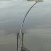
On-line Digital Images |
SC 1945115 |
Papers of James Sloan Bone, landscape historian, Inverness, Highland, Scotland |
Aerial view of Foulis Point and Cromarty Bridge, Cromarty Firth, looking SW. |
8/5/2000 |
Item Level |
|
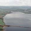 |
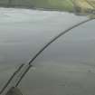
On-line Digital Images |
SC 1945118 |
Papers of James Sloan Bone, landscape historian, Inverness, Highland, Scotland |
Aerial view of Cromarty Firth, looking SW. |
8/5/2000 |
Item Level |
|


