
Plockton, General


Burgh (19th Century) (1808), Village (18th Century) (1794)
Site Name Plockton, General
Classification Burgh (19th Century) (1808), Village (18th Century) (1794)
Canmore ID 11905
Site Number NG83SW 3
NGR NG 8040 3356
NGR Description Centred NG 8040 3356
Datum OSGB36 - NGR
Permalink http://canmore.org.uk/site/11905


- Council Highland
- Parish Lochalsh
- Former Region Highland
- Former District Skye And Lochalsh
- Former County Ross And Cromarty
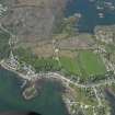
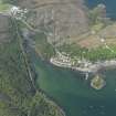
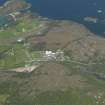
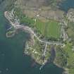
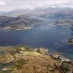
Plockton Long and orderly model village, originally known as Plock. Like Dornie, it was laid out in a spirit of economic optimism for the Earl of Seaforth by David Urquhart in 1794. It was surveyed/planned by William Cumming for Sir Hugh Innes in 1801 and feus were advertised, 1808-13. The village snakes along the edge of a sheltered inlet of Loch Carron, looking east over palm trees and wooded islets to the forested slopes of Fearnaig Crags, dark against the 'boundless chain of rugged mountains'. Above are the croftlands, today under threat of development as new housing spills over the brae beyond Frithard Road.
[From the late 18th century, the idea of creating new Planned Villages in remote Highland areas was nurtured by landlords and official bodies such as the British Fisheries Society and the Annexed Estates Commissioners. By encouraging rural industry, they hoped to ease some of the problems experienced by remote communities, which increasingly were being exacerbated by programmes of enforced re-settlement.]
Taken from "Western Seaboard: An Illustrated Architectural Guide", by Mary Miers, 2007. Published by the Rutland Press http://www.rias.org.uk

NG83SW 3 centred 803 336
Plockton was erected a burgh of regality by a crown charter in favour of Hugh Innes of Lochalsh, 25 January 1808. It was probably still recognised as a municipality at the end of the 19th century.
A L Murray 1966.
Eighty-eight roofed, three partially roofed and five unroofed buildings are depicted on the 1st edition of the OS 6-inch map (Ross-shire 1880, sheet cxvii). Seventy-eight roofed buildings are shown and on the current edition of the OS 1:10000 map (1972).
Information from RCAHMS (SAH) 6 May 1996.
Publication Account (1995)
An example of a west coast planned village begun by the Earl of Seaforth, whose factor wrote in 1794 of the necessity 'to layout the villages of Plock and Dornie'. Four years later the estate was put up for sale, and eventually bought by Sir Hugh Innes. In particulars prepared with a view to the sale, Plock is described as being occupied 'as a village and fast improving in its value and the number of its inhabitants and several good houses built and others building'. Here, as in other west coast settlements, like Ullapool, tenants were expected to combine the care of crofts with small-scale fishing. Sir Hugh Innes encouraged the new village. An advertisement in the Inverness Journal for September 16th, 1808, offered feus and ninety-nine year leases in the burgh of Plockton (now a burgh of barony, with town added to its name): 'It presents an eligible situation for a fishing station, or any branch of manufacture which requires a number of hands... The proprietor is much disposed to give every facility to any undertaking which would yield employment to the rising population...'.
A plan of 1801 shows provision for another street of houses running behind Harbour and Bank Street, but these were never built. Nevertheless, by 1841 there are said to have been 537 residents. Plockton has a unique situation for a west coast settlement. Set on the east side of a great headland sticking out into Loch Carron, it is protected from the sea gales, and looks out onto a safe anchorage where small creeks and islets diversify the coastline. Apart from what may be an old fish-house on the shore, the buildings are domestic. The early houses built in a continuous line along Harbour Street are largely early 19th century with a few later 19th century houses among them, and vary from single-storey cottages to two-storey and attic houses, some stone and some harled. Bank Street is a long row of symmetrical, single-storey and attic mid-19th-century cottages, individuality being expressed in paintwork colours and the variously carved bargeboards to the dormer windows.
Information from ‘Exploring Scotland’s Heritage: The Highlands’, (1995).

