
Pricing Change
New pricing for orders of material from this site will come into place shortly. Charges for supply of digital images, digitisation on demand, prints and licensing will be altered.
Gleann Udalain


Cultivation Remains (Period Unassigned), Dun (Period Unassigned), Enclosure (Period Unassigned)
Site Name Gleann Udalain
Classification Cultivation Remains (Period Unassigned), Dun (Period Unassigned), Enclosure (Period Unassigned)
Canmore ID 11814
Site Number NG82NE 21
NGR NG 8506 2773
Datum OSGB36 - NGR
Permalink http://canmore.org.uk/site/11814


- Council Highland
- Parish Lochalsh
- Former Region Highland
- Former District Skye And Lochalsh
- Former County Ross And Cromarty
NG82NE 21 8506 2773.
There is a hill fort on the N side of the road from Dornie to Balmacara after crossing Nostie Burn, at a height of 200' and before reaching the probable hut circle (NG82NW 4).
T Wallace 1898.
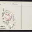
Surmounting a rocky knoll at NG 8506 2773 is the foundation of an oval dun, probably that referred to by Wallace (T Wallace 1898).
It measures overall 23.0m NNW-SSE by c. 13.0m, with the outer wall face visible in the debris for most of the perimeter except in the W where the wall has mostly slipped away. The inner face is nowhere visible, but the spread of debris suggests a wall thickness of between 3.5m and 4.0m. The entrance is not evident, but may have been in the W at the easiest approach.
Below the dun on the W is a near-circular enclosure about 10.5m in diameter within a ruinous stone wall. This seems to be relatively recent and may be contemporary with late cultivation close by.
Surveyed at 1:2500.
Visited by OS (A A) 6 June 1974; T Wallace 1898.

