
Pricing Change
New pricing for orders of material from this site will come into place shortly. Charges for supply of digital images, digitisation on demand, prints and licensing will be altered.
Upcoming Maintenance
Please be advised that this website will undergo scheduled maintenance on the following dates:
Thursday, 9 January: 11:00 AM - 3:00 PM
Thursday, 23 January: 11:00 AM - 3:00 PM
Thursday, 30 January: 11:00 AM - 3:00 PM
During these times, some functionality such as image purchasing may be temporarily unavailable. We apologise for any inconvenience this may cause.
Eigg, Five Pennies


Corn Drying Kiln (Medieval) - (18th Century), Field System (Medieval) - (18th Century), Township (Medieval) - (18th Century)
Site Name Eigg, Five Pennies
Classification Corn Drying Kiln (Medieval) - (18th Century), Field System (Medieval) - (18th Century), Township (Medieval) - (18th Century)
Alternative Name(s) Cuig Peighinnean; Tolain
Canmore ID 118020
Site Number NM48NE 39
NGR NM 4785 8975
NGR Description Centred NM 4785 8975
Datum OSGB36 - NGR
Permalink http://canmore.org.uk/site/118020


- Council Highland
- Parish Small Isles
- Former Region Highland
- Former District Lochaber
- Former County Inverness-shire
NM48NE 39 centred 4785 8975
A township, comprising two roofed, one partially roofed building, six unroofed structures, two enclosures and a field-system is depicted on the 1st edition of the OS 6-inch map (Inverness-shire Island of Eigg 1879, sheet lxxi). One roofed structure which is part of the sheepfold, six unroofed buildings, four enclosures and the field-system are shown on the current edition of the OS 1:10000 map (1976).
Information from RCAHMS (AKK) 9 December 1996.
Scheduled as Cuig Peighinnean (Five Pennies), township and field-system North of Howlin, Eigg.
Information from Historic Scotland, scheduling document dated 23 February 2004.
Field Visit (15 May 2001)
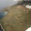
This township is situated on broken ground between the cliffs of Guala Thoinisteir and the coast to the W. The nucleus of the settlement, which comprises nineteen buildings, a corn drying kiln, a mound and at least seven small yards or enclosures, lies about 180m N of Howlin farmhouse (NM48NE 49), at the edge of an extensive system of irregular fields. It is bisected by a trackway that runs from N to S and also by a burn that drains S from Tobar Cuidh Capuill about 100m to the N (NM48NE 83). A second spring, Tobar Mhor Tholain, is situated at the S edge of the settlement (NM 47799 89727).
The buildings, which are all rectangular or sub-rectangular on plan are mostly distinguished by rounded external corners. They measure between 3m and 9.8m long and between 2.2m and 3.8m transversely, usually within stone or boulder-faced turf walls (sometimes incorporating edge-set stones) up to 1.5m thick and 0.9m high. Three have been almost entirely removed as a result of stone robbing (316-18), while the mound may also represent a collapsed structure (321). Faint indications of a midden are visible immediately NW of one building (301) and a byre-drain is associated with another (302). However, one of the more poorly preserved structures is exceptional in measuring 16.5m from NE to SW by 3.2m transversely within a grass-grown rubble-faced wall 1.3m thick and 0.4m high (312). A corn drying kiln is situated about 10m to its SSW. Its kiln bowl, which is partly choked with rubble, measures 0.8m in diameter and at least 0.9m deep.
Clear indications of phasing are rare, but a smaller building has been built over the central portion of the exceptionally long structure and there is at least one other instance where one appears to overlie another (300-301). Two roofless buildings associated with a roughly trapezoidal enclosure immediately S of a modern roofed shed are also relatively late in date (659-60).
Most of the enclosures are attached to a building, although the largest stands alone to the E of the track (304). It is roughly oval on plan and measures 26.8m from NNE to SSW by 12.8m transversely, within a stone-faced wall 1m thick.
Some of the fields contain traces of rig cultivation. Their wide variation in size and shape suggests a piecemeal process of expansion and enclosure. Such field systems are common on the W coast of Scotland - notable examples having been recorded at Achiltibuie (RCAHMS 1997) and on Waternish, Skye (RCAHMS 1993). They have probably survived here because they lie outwith the Cleadale crofting settlement, which was established to the south in 1809. The Five Pennies township and its fields are shown in some detail on Bald's map (1806) and an outline of its history is provided in recent summaries of the island's story (Wade-Martins 2004, Dressler 1998). Three of the buildings are shown roofed (300, 659-660) and five unroofed (303, 305?, 308, 310, 312) on the 1st edition of the OS 6-inch map (Inverness-shire (Skye) Sheet LXXI, 1879).
(EIGG01-97, 300-21, 659-660, 755)
Visited by RCAHMS (SDB) 15 May 2001
Publication Account (2002)
The remains of this township stand to the north of Howlin farmhouse. The name presumably originates from the medieval assessment of Howlin, the earliest record of which is found in a charter of 1498, by which James IV granted '5 den. Terrarum de Houland' to Ranald Maccallan, Captain of Clanranald.
The visible remains comprise the footings of about two dozen buildings, a corn-dying kiln and several small yards and enclosures at the edge of an extensive system of irregular fields. The buildings are all roughly rectangular, most of them having rounded external corners, and are constructed of turf faced inside and out with large stones and boulders, many of them set on edge. This building style, which was described by the Catholic Bishop Nicolson in 1700, is found throughout the surviving remains of pre-crofting townships on the island, and contrasts with the rubble-cored walls of the later period buildings. In one instance, close to the centre of the township, two buildings are joined along one side, an arrangement commonly found amongst blackhouses in the Western Isles, where byres and other ancillary buildings would often be added to one side of the main house, rather than at its end.
Around the township there are well-preserved fields of irregular plan, enclosed by substantial turf and stone dykes, within which fragments of rig cultivation can be traced. Their wide variation in size and their irregular form strongly suggest a gradual, piecemeal process of expansion and enclosure of arable land. Field-systems such as this are common on the west coast of Scotland - examples have been recorded by RCAHMS at Archiltibuie and on Waternish, Skye. The Five Pennies field-system has probably survived because it lay outwith the Cleadale crofting settlement established immediately to the south in 1809, where only fragments of a comparable system can be seen today. Robert Dodgshon has argued that such field-systems are a relict of pre-feudal regime of landholding, superceded, perhaps during the late medieval period, by a runrig system of open fields held by joint tenants who regularly re-allocated land amongst themselves. However, it could also be argued that a runrig system is not incompatible with the enclosure of areas of land, which might have been necessary to control stock movements, particuarly under what Dodgshon has called a 'grass-arable' cropping regime. By this he means that part of the arable was cropped for two to four years before being abandoned to grass. Under such a regime, manuring by stock during the fallow years would probably have required a system of dykes to control the folding and manuring process.
Information from ‘RCAHMS Excursion Guide: Commissioners' Field Excursion, The Small Isles, 23-26 September 2002’.

