
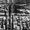
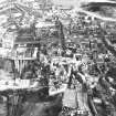
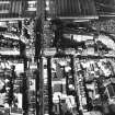
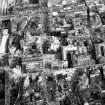
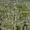
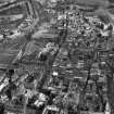
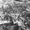
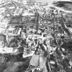
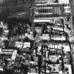
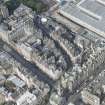
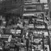
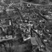
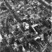
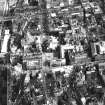
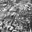
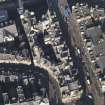
Edinburgh, Cockburn Street, General


General View (Period Unassigned)
Site Name Edinburgh, Cockburn Street, General
Classification General View (Period Unassigned)
Canmore ID 116453
Site Number NT27SE 1240
NGR NT 25800 73704
Datum OSGB36 - NGR
Permalink http://canmore.org.uk/site/116453


- Council Edinburgh, City Of
- Parish Edinburgh (Edinburgh, City Of)
- Former Region Lothian
- Former District City Of Edinburgh
- Former County Midlothian
ARCHITECTS: Peddie & Kinnear 1859
REFERENCE: PLANS
Dick Peddie & MacKay, Edinburgh alterations to Horseshoe Bar
Attic 2, Bin 22, Bag 2 1955
Dick Peddie & MacKay, Edinburgh new (elevation of South side)
Attic 2, Bin 23, Bag 2 Peddie & Kinnear 1859
Dick Peddie & MacKay, Edinburgh new
Bin 12, Bag 2 Peddie & Kinnear 1859-60
Dick Peddie & MacKay, Edinburgh elevations
Drawings in Plan chest drawer 4 Peddie & Kinnear N.D.
For Railway Station Access co
PLANS:
Dick peddie & MacKay, Edinburgh plan of proposed new street
Bin 18, Bag 3 Peddie & Kinnear 1859
REFERENCE: CITY ARCHITECTS' PLAN STORE
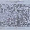
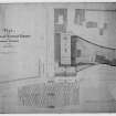
Drawer No 14.-I.No 40:- Mounted lithographed plan headed "Edinburgh Railway Station Access Co., Plan of Street to be formed from Waverley Bridge Road to High Street". Scale 30 feet to 1 inch. No date, but probably 1851, when the scheme was projected. The centre line is shown by a heavy line and the sides of the Street by dotted lines, while a note indicates that the dotted lines furthest from the centre indicates the limit of property which the Company is empowered to take under their Act. The plan is printed by W & A K Johnston and bears the name of J Dick Peddie.
Drawer No 28.-II.No 33:- Lithographed plans showing "Line of proposed New Road-way from Waverley Bridge to the Tron Church". Dated 1851. Scale 30 feet to 1 inch.
Drawer No 28.-III.No 37:- Lithographed sheet to scale of 30 feet to 1 inch showing a series of Cross Sections through present road and the surface of the proposed street; and Section showing rate of inclination as 1 in 12.84 throughout. The length indicated-from side of Market Street to side of High Street-is 1 furlong, 184 links. There is no date, but pencil note would indicate 1858.
Drawer No 17.-IV.:- Rough cloth tracing showing buildings between Fleshmarket and Anchor Close, on the North side of Cockburn Street. Numbers run from 41 to 63, and on a panel on the front is the date 1864. The tracing is docketted as (signed) Peddie & Kinnear, Archts, 1 July, 1862.
Drawer No 20.-V.:- Alternative elevations of wall opposite Royal Exchange, on which offers were received. Scale one and a half inch to ten feet. Signed by Peddie & Kinnear, Archts, 12 Howe Street, 10 March, 1859.
REFERENCE: NMRS HISTORICAL FILE
10 pages of text regarding the development of Cockburn Street and its effects on the surrounding areas -filed under "COCKBURN STREET"
NMRS REFERENCE:
Plans: lithograph perspective view (coloured) presentation design.
Peddie and Kinnear archts. Published and painted by Messrs Caldwell and Co.
Unable to locate at time of upgrade 15.2.2000.

