
Pricing Change
New pricing for orders of material from this site will come into place shortly. Charges for supply of digital images, digitisation on demand, prints and licensing will be altered.
Downhill


Farmstead (Period Unassigned)
Site Name Downhill
Classification Farmstead (Period Unassigned)
Canmore ID 116332
Site Number NO11SW 39
NGR NO 1036 1154
Datum OSGB36 - NGR
Permalink http://canmore.org.uk/site/116332


- Council Perth And Kinross
- Parish Arngask
- Former Region Tayside
- Former District Perth And Kinross
- Former County Perthshire
Note
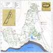
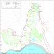
A farmstead, which comprises two roofless buildings and an enclosure, is depicted on the 1st edition of the OS 6-inch map (Perthshire 1866, sheet 120) and annotated 'Ruins'. The farmstead is not shown on the current edition of the OS 1:10000 map (1987).
Information from RCAHMS (PM) 13 December 1996.

