
Downhill


Farmstead (Period Unassigned)
Site Name Downhill
Classification Farmstead (Period Unassigned)
Canmore ID 116332
Site Number NO11SW 39
NGR NO 1036 1154
Datum OSGB36 - NGR
Permalink http://canmore.org.uk/site/116332


- Council Perth And Kinross
- Parish Arngask
- Former Region Tayside
- Former District Perth And Kinross
- Former County Perthshire
Note
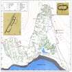
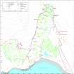
A farmstead, which comprises two roofless buildings and an enclosure, is depicted on the 1st edition of the OS 6-inch map (Perthshire 1866, sheet 120) and annotated 'Ruins'. The farmstead is not shown on the current edition of the OS 1:10000 map (1987).
Information from RCAHMS (PM) 13 December 1996.

