
Pricing Change
New pricing for orders of material from this site will come into place shortly. Charges for supply of digital images, digitisation on demand, prints and licensing will be altered.
Skye, Boreraig


Township (Period Unassigned), Township (Period Unassigned)
Site Name Skye, Boreraig
Classification Township (Period Unassigned), Township (Period Unassigned)
Alternative Name(s) Borreraig
Canmore ID 11562
Site Number NG61NW 6
NGR NG 619 164
Datum OSGB36 - NGR
Permalink http://canmore.org.uk/site/11562


- Council Highland
- Parish Strath
- Former Region Highland
- Former District Skye And Lochalsh
- Former County Inverness-shire
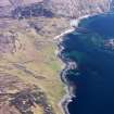
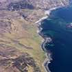
Boreraig and Suisinish Clearance villages on Loch Eishort's northern shore, with rich evidence of settlement and land use spanning centuries. Boreraig is particularly haunting, surviving almost as it was when cleared in 1852. According to Lord Macdonald's factor, the evictions were 'prompted by motives of benevolence, piety, and humanity … because they were too far from the church'.
Taken from "Western Seaboard: An Illustrated Architectural Guide", by Mary Miers, 2008. Published by the Rutland Press http://www.rias.org.uk

NG61NW 6 619 164.
NG 619 164 Boreraig: cleared by Lord MacDonald in 1852, (Nicolson 1930) - still partly occupied in 1901, (OS 6"map, Inverness-shire, 2nd ed., 1903) but totally deserted by 1954-5 (OS 1"map, 7th series)
A Nicolson 1930.
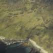
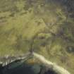
The depopulated township of Beoreraig is situated on grassy slopes which rise gently from the shore on the N side of Loch Eishort; it comprises about 12 houses and some 15 outbuildings of a typical improvements township. Within its bounds are two later buildings, mortar bonded, which were occupied in 1901, and are probably the shepherd's house which superseded it.
Visited by OS (C F W) 23 June 1961.
A township, comprising five roofed buildings, one partially roofed building and eighteen unroofed buildings is depicted on the 1st edition of the OS 6-inch map (Inverness-shire, Isle of Skye 1881, sheet li). A crofting township of thirty-four unroofed buildings is shown on the current edition of the OS 1:10000 map (1988).
Information from RCAHMS (AKK) 29 November 1996.

