
Keiss


Pillbox (20th Century)
Site Name Keiss
Classification Pillbox (20th Century)
Alternative Name(s) Wic 102; Keiss Harbour, Pillbox
Canmore ID 115450
Site Number ND36SE 43
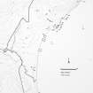
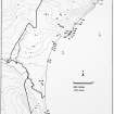
NGR ND 35367 61089
Datum OSGB36 - NGR
Permalink http://canmore.org.uk/site/115450


- Council Highland
- Parish Wick
- Former Region Highland
- Former District Caithness
- Former County Caithness
ND36SE 43 35367 61089
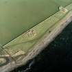
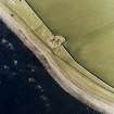
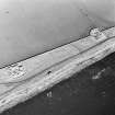
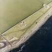
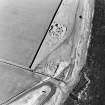
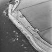
ND 3540 6115. Pillbox, Keiss. Dimensions: hexagonal, N-S side 4.95m, E-W sides c 3m, height 1.25-2.3m. Complete, but with some superficial damage. Located at the beach head. SE aspect.
C E Batey, Caithness Coastal Survey, 1981
A type 24 brick and concrete pillbox is situated on the shore N of Keiss Harbour.
J Guy 2000; NMRS MS 810/10, Vol.1, 20, Vol.3, 22
This type 24 pillbox is visible on RAF vertical air photographs (106G/Scot/UK 75, 3003-3004, flown 9 May 1946), situated just above the high water mark about 56m ENE of Keiss Broch (ND36SE 2)
Information from RCAHMS (DE), October 2004
Project (1980 - 1982)
Field Visit (1981)
ND 3540 6115. Pillbox, Keiss. Dimensions: hexagonal, N-S side 4.95m, E-W sides c 3m, height 1.25-2.3m. Complete, but with some superficial damage. Located at the beach head. SE aspect.
C E Batey, Caithness Coastal Survey, 1981

