
Following the launch of trove.scot in February 2025 we are now planning the retiral of some of our webservices. Canmore will be switched off on 24th June 2025. Information about the closure can be found on the HES website: Retiral of HES web services | Historic Environment Scotland
Skye, Dun Grugaig


Galleried Dun (Prehistoric)
Site Name Skye, Dun Grugaig
Classification Galleried Dun (Prehistoric)
Canmore ID 11442
Site Number NG51SW 1
NGR NG 53527 12308
Datum OSGB36 - NGR
Permalink http://canmore.org.uk/site/11442


- Council Highland
- Parish Strath
- Former Region Highland
- Former District Skye And Lochalsh
- Former County Inverness-shire
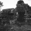
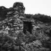
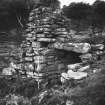
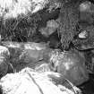
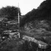
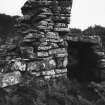
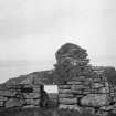
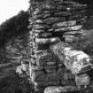
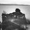
NG 535 123 The visible remains of this dun consist of a massive dry-stone wall 4.5 metres thick which lies across the neck of the promontory. This wall survives to a maximum of 4.5 metres above present ground level. A central, well built, entrance passage has most of its original lintels in position and a well defined door check with bar holes survives at the landward end of the passage. The basal stones of the wall are of massive size, the main body of the wall, however, consists of well laid 'flats' which have been pinned at the faces to maintain level coursing.
Consolidation and Re-pinning of the standing walls was undertaken on this site and completed on the 2nd of December 1998.
M Wildgoose 1998
NG51SW 1 5354 1229.
(NG 5354 1229) Dun Grugaig (NR)
OS 6"map, Inverness-shire, 2nd ed., (1928)
Dun Grugaig, a galleried dun, measures 69ft externally along the major axis from NW-SE and varies in width from 24ft at the NW to 35ft at the opposite end. It is def- ended on the landward side on the NW, by a massive stone wall 141/2ft thick, standing to a height of 13ft above the inside level and 7ft 2ins to a gallery floor above the outside. The walling around the other sides has been much narrower, apparently only about 5ft thick, but the inside face is destroyed.
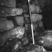
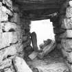
Not only is the finely-built passage in the centre of the NW wall complete, with six of its seven lintels in position, but part of a gallery immediately above is traceable for 7ft towards the SW, and apparently has been carried over in the NE, where, at about 51/2ft from the inside of the entrance, an opening contains the first three treads of a flight of steps, presumably leading up to it from the court. The inner wall of the gallary, which is still 6ft high in parts, is 4ft 10ins thick, and the outer wall, which shows a height of only a few inches, is 41/2ft thick. The gallery has been provided with at least one opening looking into the interior of the dun,the west jamb being still in situ above the entrance passage. On the inside of the main wall is a scarcement. The passage has door checks and bar holes.
Some of the stones of this dun are of considerable size, one of the foundation stones on the outer face to the right of the entrance being 8ft in length. The outer lintel is also a big stone.
(RCAHMS 1928; A Graham 1949).
Dun Grugaig is as described by RCAHMS
Visited by OS (C F W) 14 June 1961.
Field Visit (21 June 1921)
Dun Grugaig, Elgoll.
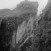
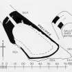
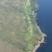
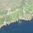
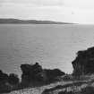
Dun Grugaig occupies the summit of a roughly rectangular-shaped rocky promontory increasing in width towards the sea, and rising sheer 50 feet above it on the eastern side of Strathaird peninsula, about 1¾ miles south-east of Elgoll and ¾ mile north-north-east of Rudha nah-Easgainne, the most southerly point in the peninsula. The dun measures 69 feet externally along the major axis from north-west to south-east, and varies in width from 24 feet at the north-west to 35 feet at the opposite end. It is defended, across the narrow neck of the landward side on the north-west, by a massive stone wall 14½ feet thick, standing to a height of 13 feet above the inside level and 7 feet 2 inches to a gallery floor above the outside. The walling round the other sides has been much narrower, apparently only about 5 feet thick, but the inside face is destroyed. (Fig. 298.)
Not only is the finely-built entrance passage in the centre of the north-west wall complete, with six of its seven lintels in position, but part of a gallery immediately above, 4½ feet broad, is traceable for 7 feet towards the south-west, and apparently has been carried over in the north-east, where, at about 5½ feet from the inside of the entrance, an opening 1 ¾ feet wide contains the first three treads of a flight of steps, presumably leading up to it from the court. The inner wall of the gallery, which is still 6 feet high in parts, is 4 feet 10 inches thick, and the outer wall, which shows a height of only a few inches, is 4½ feet thick. The gallery has been provided with at least one opening looking into the interior of the dun, the western jamb being still in situ above the entrance passage. On the inside of the main wall, at the level of the lintels of the passage, is a scarcement 8 inches broad. The passage is 14½ feet long; at the outside it is 4 feet high, 2 2/3 feet wide at top and 3 feet at bottom of the wall, and at the inside it increases in height to 5½ feet and in breadth to 3½ feet at the top and 3 ¾ feet at the bottom. There are door checks 6½ inches on the eastern, 5 inches on the western side of the passage and 3 feet 2 inches from the exterior, with a bar hole 2¾ feet from the ground, measuring 9 inches in height and 7 inches in breadth.
Some of the stones in this dun are of considerable size, one of the foundation stones on the outer face to the right of the entrance being 8 feet in length, 1¼ feet in breadth, and 1½ feet in height. The outer lintel is also a fine big stone, 4½ feet in length on its lower side, 2½ feet on the top, 2 feet 2 inches high and 1¼ feet thick.
RCAHMS 1928, visited 21 June 1921.
Skye l.
Publication Account (2007)
NG51 1 DUN GRUGAIG 1
NG/5354 1229
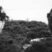
This well preserved, unexcavated promontory semibroch (or “galleried dun” [2]) in Strath, Skye, is situated on a narrow, sheer-sided cliff promontory about 15m (50 ft) high and at the foot of a long, fairly steep slope (visited 19/4/63, 19/8/85, and in 1986 and 1988). This part of the coast is formed of a block of horizontally bedded Jurassic sandstone which terminates in a sheer cliff; this has been eroded into sheer-sided inlets very similar to the north-east coast of Caithness.
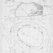
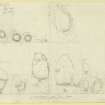
In addition to the plan prepared by the Royal Commission in 1921 two more detailed plans of the site are available [8, 909, and 9, fig. 7]; the north point on the latter (the author's) became reversed during re-drawing.
Dun Grugaig is a dangerous site to visit because sea erosion has narrowed the neck of the promontory and the clefts in it – next to the path – can be concealed by bushes. The fragmentary remains of the Level 2 stonework are fragile and could easily be destroyed. Nevertheless this site – like Dun Ringill (NG51 4) and Rudh’ an Dunain (NG31 1) also on Skye, and Dun Grugaig 2 near Glenelg (NG81 1) – is an extremely important one for understanding the early development of the broch hollow wall.
1. Description
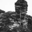
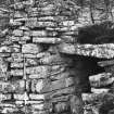
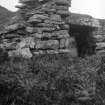
Although the structure has been described as rectangular [4] the shape is dictated by the limited area of the promontory on which it stands; the salient feature is in fact the massively thick and short cross-wall. This is hollow-built, on top of a solid base, but the remains of only one upper gallery survive. This cross-wall is 4.4m thick at the centre and the front face is markedly battered.
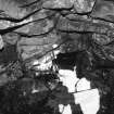
The entrance passage is in the middle and most of its lintels are still in position, the ones behind the checks having no gaps between them. The two front lintels are set on edge and are exceptionally massive, the front one having the shape of a truncated triangle. There may be up to about 80cm of debris on the passage floor at the front end but less further back. The door-frame is 1.5m from the outside and has two built rebates with a bar-hole (on the left) and opposed socket behind these. There is no guard cell. At present the entrance is 1.2m (4 ft) high at the outer end and 91cm (3 ft) wide at the base, narrowing slightly at the lintels. At the inner end it is 1.65m (5.5 ft) high and 1.15m (3 ft 9 in) wide at the base.
There is a clearly defined chamber above the passage roof which communicates with the interior; its right face is traceable all the way forward as far as the massive front lintel. This is not shown on the Commission's plan [2] which wrongly implies that the outer half of the front wall in Level 2 is continuous. A short length of upper gallery runs at an angle from this chamber towards the south, and the inner half of the chamber, and of the gallery wall so defined, is still preserved to a height of 1.5m as a rather precarious block of masonry. There is a possibility that there may have been defensive gaps, or meurtrières, between three of the flat lintels in front of the door-frame but the central one of the three is displaced and confirmation cannot now be obtained.
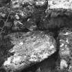
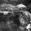
The remains of a ledge scarcement 20cm (8in) wide is visible on the interior wallface to the right (west) of the passage but only one surface slab of this remains, next to the passage; this ledge is about 60cm (2 ft) below the level of the passage lintels – an unusual arrangement. Thus it would have been difficult, without wooden steps, to get up into the chamber over the entrance from any hypothetical wooden balcony resting on the ledge in the interior.
In the inner wallface to the left of the passage, and 1.5m from it, is a narrow opening leading into the wall; immediately inside this a few steps of a narrow stairway can be seen ascending directly into the wall, with a slight suggestion of the start of a curve round to the left, towards the entrance. This stair must have risen through the solid wall base into the upper gallery which presumably ran all the way along the thick cross-wall. It may in fact have led up over the entrance passage to a second upper gallery. This intra-mural stair is unique among all known brochs and broch-like structures in that it runs straight into the wall and then, presumably, turns through a right angle to line up with the gallery. It is also almost unique in rising in an anti-clockwise direction; only the analogous ‘forework’ at Clickhimin in Shetland (HU44 1) has a stairway similarly rising to the left, or counter-sunwise.
At both cliff edges the thick cross-wall turns backwards (towards the open sea) and – thinning rapidly and much reduced in height – runs along the edge of the promontory for a short distance. Since the line of blocks of the foundation course on the north-west side can be traced for some 12m back from the entrance passage it seems likely that the whole promontory was surrounded by this narrow wall, as is shown on the Commission's plan [2, fig. 210, fig. 294]. Its thickness can be measured as 1.5m on the north-east side and 2m on the south-west. The broken west end of the main cross-wall makes it clear that the structure is solid at ground level.
It has been said that "Because of the danger posed by the high cliffs forming the promontory margins, it is impossible to ascertain whether the outer face of the (main) wall turns along each margin, or has fallen away as the result of erosion." [8, 907]. In fact the outer faces of the walling along the south-west and north-east cliff edges were clearly visible at that time for many metres, as is shown on the author's plan and, even more plainly, on the Commission's, which was made in 1921 [2, 210, fig. 294).
2. Discussion
Dun Grugaig is one of four classic promontory semibrochs in the Inner and Outer Hebrides and is closely related architecturally to the 'blockhouse' at Clickhimin in Shetland (HU44 1) [5, 140, Table] (these parallels are elaborated below). From this latter similarity a date in the 7th or 6th centuries BC, in the early Iron Age, may be tentatively inferred for this unexcavated building (vol. 1, 110 ff: MacKie 2005, 111ff.).
Level I of the structure consists of a short, thick, slightly curved, solid wall barring the neck of the cliff promontory and extending, as a thinner side wall, all the way round the enclosed area. The entrance which pierces the cross-wall in the middle is of classic broch type and there is a scarcement of the ledge-type on the inner face, perhaps 1.8m above the original ground surface. The inner face of the cross-wall is even more curved than the outer so it is possible that a wooden roundhouse, containing a raised peripheral balcony resting on the ledge, could have been attached to it if it was slightly oval in plan. Excavations would be required to check this hypothesis which would require a ring of post-holes immediately inwards from the entrance. Such an oval roundhouse would have been quite small and would have had an internal diameter of about 5.4m (17.7 ft) from south-west to north-east.
Level II: only a fragment of the second storey of the cross-wall is preserved but this shows clearly that the classic, sophisticated hollow-walled broch architecture was employed at this site. The chamber over the entrance extends as far forward as the massive front lintels, which evidently supported the high outer face of the cross-wall (which probably contained a second and perhaps a third gallery). The first floor gallery apparently crosses this chamber (though it is only preserved on the right), implying that the cross-wall was much higher than the rest. The intra-mural stair seems likely to have risen over the chamber over the entrance rather than connected with it (the inner end of which would have been accessible from the wooden floor resting on the scarcement) and to have connected with a second and perhaps even a third gallery. However the shortness of the cross-wall perhaps implies that a third gallery would have been too high for the stair to reach in the space available.
In typological terms, and also because of the available dating evidence from similar sites, Dun Grugaig seems likely to be one of the earliest structures of the broch class of buildings; in many ways it bears a striking resemblance – both in shape and proportions – to the 'blockhouse' at Clickhimin in Shetland (HU44 1). This close similarity implies that Dun Grugaig probably belongs to the same period, probably to the 6th century BC, perhaps even the 7th.
The promontory wall here contrasts with Rudh an Dunain, Skye (NG31 1), and Sron an Duin in Berneray (NL58 1) in that the ends of the cross-wall curve round to merge with the thinner side walls; in the other two promontory semibrochs mentioned the cross-walls run straight to the cliff edges and seem to finish with built ends (one of which is visible at Sron an Duin). In this sense Dun Grugaig is closer to a D-shaped semibroch like Dun Ringill (NG51 4), Skye (below), and Dun Grugaig in Glenelg (NG81 1). On the other hand Rudh’ an Dunain has the standard form of gallery door in the interior wallface with, presumably, the stairway a short distance down the gallery to its right and rising clockwise. The intra-mural stair in Dun Grugaig is atypical.
The parallels between the design of Dun Grugaig, Skye, and the Clickhimin 'block-house' in Shetland are so numerous that, as noted, they must surely imply a very close relationship and a similar age [5]. These similarities include –
(1) a central entrance passage in a slightly curved wall (the other two promontory semibrochs having their entrances at one end).
(2) a smoothly battered outer wallface.
(3) a ledge scarcement on the inner face.
(4) a standardised 'broch' entrance passage but without a guard cell.
(5) large flat lintels roofing the passage with a chamber above.
(6) an upper gallery which runs across over the entrance and thereby communicates with the chamber over the entrance from both sides (this 'cross-shaped' design of the first floor features over the entrance does not normally occur in brochs). This feature is also seen in the C-shaped semibroch Dun Ringill, not far away (NG51 4).
(7) the fact that the entrance section in both sites is wider than the rest of the wall to which it is attached (built as a separate block of masonry in the case of Clickhimin).
(8) the chamber over the entrance extends forward to the front lintel.
(9) the intra-mural stair rises from the right end of the wall (looking out) anti-clockwise towards the central passage. Every other known broch stair rises clockwise or sunwise, to the right, from its doorway and away from the entrance passage.
There are a number of differences between the two sites the most important of which are –
(1) the two large mural cells in Clickhimin which contrast with the solid wall base of Dun Grugaig.
(2) The stairway in Clickhimin rises from the end of the building (but perhaps from inside a galleried wall) and not from a door in the inner face.
(3) Clickhimin was built as a separate block of masonry to the ends of which galleried walls were apparently attached.
The overall impression gained from Dun Grugaig is that in the sophistication of its hollow-walled architecture – particularly in the design of the entrance passage, the neatly constructed chamber over the entrance, the upper gallery and the scarcement ledge – the structure is hardly inferior to a well built broch. However in terms of the design and situation of the stronghold it is markedly inferior, being confined on a cramped sheer-sided promontory at the foot of a steep and awkward slope which leads straight to a cliff and is now covered with thickets and bogs.
Sources: 1. NMRS site no. NG 51 SW 1: 2. RCAHMS 1928, 210, no. 651, figs. 294 and 298: 3. Young 1962, 192: 4. Feachem 1963, 185: 5. MacKie 1965, 139: 6. MacKie 1975, 164 and fig. 24: 7. MacSween 1984-85, 50, no. 59 and fig. 59: 8. Swanson (ms) 1985, 907-09 and plan: 9. MacKie 1991, 166-68 and fig. 7.
E W MacKie 2007

