
Following the launch of trove.scot in February 2025 we are now planning the retiral of some of our webservices. Canmore will be switched off on 24th June 2025. Information about the closure can be found on the HES website: Retiral of HES web services | Historic Environment Scotland
Skye, Eilean Ruaridh


Fort (Prehistoric)(Possible), Smithy (Period Unknown)(Possible), Vitrified Stone (Prehistoric)(Possible)
Site Name Skye, Eilean Ruaridh
Classification Fort (Prehistoric)(Possible), Smithy (Period Unknown)(Possible), Vitrified Stone (Prehistoric)(Possible)
Canmore ID 11441
Site Number NG51SE 2
NGR NG 5947 1237
Datum OSGB36 - NGR
Permalink http://canmore.org.uk/site/11441


- Council Highland
- Parish Sleat
- Former Region Highland
- Former District Skye And Lochalsh
- Former County Inverness-shire
NG51SE 2 5947 1237.
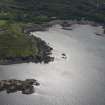
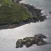
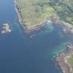
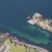
(NG 5947 1237) Structure, Eilean Ruairidh. This islet is one of a small group about 300 yards NW of Dun Scaich (NG51SE 1) and about 200 yards from the shore. Its triangular crest is surrounded by the tumbled remains of a stone wall, the debris averaging from 6 to 10ft in width. As there is an unusually large proportion of small stones, the wall could not have stood very high. Here and there a foundation course of larger stones can be traced, indicating the general outline. There are indications of internal shelters against the E side. As some small lumps of stone show distinct traces of fusion by fire, it has been assumed that this has been a vitrified fort. But such pieces are loose and sporadic in occurrence and have probably been brought to the spot. The local belief is that there was once a smithy on the island.
The remains of a vitrified fort - possibly the original castle of Dun Scaith (M E M Donaldson 1923).
(RCAHMS 1928).
The site is as described by RCAHMS. No certain evidence of vitrifaction was seen.
Visited by OS (A C) 26 June 1961.
Field Visit (24 June 1921)
Structure, Eilean Ruairidh.
This islet is one of a small group about 300 yards north west of Dun Scaich and 200 yards from the shore. Its triangular crest is surrounded by the tumbled remains of a stone wall, the debris averaging from 6 to 10 feet in width. As there is an unusually large proportion of small stones, the wall could not have stood very high. Here and there a foundation course of larger stones can be traced, indicating the general outline. There are also indications of internal shelters against the east side. As some small lumps of stone show distinct traces of fusion by fire, it has been assumed that this has been a vitrified fort. But such pieces are loose and sporadic in occurrence and have probably been brought to the spot. The local belief is that there was once a smithy on the island.
RCAHMS 1928, visited 24 June 1921.
OS map: Skye li.
Project (23 October 2010 - 12 November 2010)
A desk-based assessment and walkover survey were undertaken in advance of a proposed woodland management scheme. The work was undertaken to assess the nature and extent of any archaeology likely to be affected by the scheme and to inform recommendations for the protection and management of any sites. Several new sites were recorded during fieldwork.
Information from S. Birch - West Coast Archaeological Services, 2010.
OASIS ID: westcoas1-87220

