
Pricing Change
New pricing for orders of material from this site will come into place shortly. Charges for supply of digital images, digitisation on demand, prints and licensing will be altered.
Skye, Dun Scaich


Castle (Medieval)
Site Name Skye, Dun Scaich
Classification Castle (Medieval)
Alternative Name(s) Tokavaig; Dunscaith Castle; Dun Sgathaich
Canmore ID 11440
Site Number NG51SE 1
NGR NG 5952 1207
Datum OSGB36 - NGR
Permalink http://canmore.org.uk/site/11440


- Council Highland
- Parish Sleat
- Former Region Highland
- Former District Skye And Lochalsh
- Former County Inverness-shire
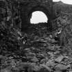
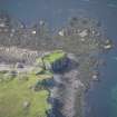
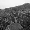
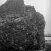
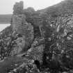
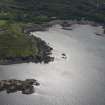
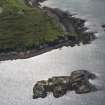
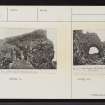
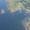
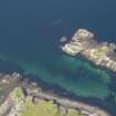
Dun Scaith Castle (Dùn Sgàthaich), possibly 13 th century Occupying an older fortified site, originally a vitrified fort, this fragmented castle of enclosure perched on a rock above Loch Eishort was a stronghold of the Macleods before it became the principal seat of the Macdonalds of Skye (Clann Ùisdein) in the 15th century. (After more than a century of sieges and inter-clan hostility, the Macdonalds moved back to Duntulm in the early 17th century.) The castle is approached over a gully bridged by two walls. These flanked a drawbridge, whose pivot holes are still visible on the far side. Here, a door opened onto a flight of steps leading up between walls to the castle (these outworks appear later than the castle structure, and are not bonded-in). Parts of the curtain wall - one of the earliest surviving examples of lime-mortared construction in the district, being of random rubble with smaller infill - still cling to the cliff edge. But what survives of the internal structures, which probably included a tower, is identifiable only by grassy mounds. In the courtyard is a well, and at the south-east angle are remains of a stair within a tower leading to the parapet walkway. Later rebuilding is particularly apparent on the eastern, landward wall.
[Among the many legends associated with Dun Scaich are those recounted in Macpherson's 'Ossian' concerning the adventures of the Irish folk hero Cu Chulainn, who came here when he first landed in Skye. One tradition tells how he came here to learn the marshall arts of war from the warrior queen 'Sgathaich', whose home this was.]
Taken from "Western Seaboard: An Illustrated Architectural Guide", by Mary Miers, 2007. Published by the Rutland Press http://www.rias.org.uk

NG51SE 1 5952 1207.
NG 5952 1207. Dun Scaich (NR) (Ruins of)
OS 6" map, Inverness-shire, 2nd ed., (1903)
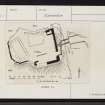
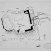
Dun Scaich occupies the whole summit of an isolated rock at N Corner of Ob Garscavaig on the S shore of Loch Eishart. The rock is wholly precipitous and rises some 30-40ft above the sea and is cut off from the mainland by a steep gully or trench about 20ft wide and 15 - 16ft deep hewn out of the natural rock and strewn with angular pieces of stone debris. This gully is crossed by two arched walls, 6ft apart enclosing a space for a wooden drawbridge. At the inner extremity of the gap are the holes for the pivot upon which the drawbridge worked. Immediately beyond are the projecting checks for a door which opened to a flight of steps, the higher part of which has disappeared. It is clear that the whole summit of the rock measuring about 30 x 22 yards was originally enclosed by walling, of which portions varying in height still cling to the cliff edge. About a third is completely gone or is buried under grassy mounds. The highest part remaining is in the SE corner, where it rises at most to 16 - 17ft. Where complete the surrounding wall averages 5ft thick. There are only fragments of interior walling and no features worth noticing. An oblong building, 38 x 16ft with 4 1/2ft walls, occupied the extreme W of the enclosed area, but its foundations are now defined only by grass-grown mounds. There is another but much more indefinite area on the N side. A built well is now filled with debris. There seems to have been a garderobe in the NE corner and in the S face a sea-gate.
The building is of unusual character in the Western Isles, random rubble roughly coursed in large irregular stones with much infilling of small material and plenty of lime. The work on the bridge and stair looks later than that of the main structure and is not bonded in. The building is in bad condition.
Properly Dun Scaich is Dun Sgathaich, which explains the form in a charter of 1505, "terrarum de Sleit una cum castro et fortalicio de Dunskayay (Reg Magni Sig Reg Scot 1984, Vol. 2)." In highland tradition it was the Dun of Scathach the martial instructress of the epic hero Cuchullin. There was probably a more ancient structure of the dun class. It was the principal seat of the Clan Huisdean of Macdonalds of Sleat. In 1515 there was a remission to Lauchlan MacLean of Dowart and Alistair Macleod of Dunvegan for assisting "in the treasonable segeing and taking of the Kingis castillis and hous of Carnebog and Dunskaith" (Reg Magni Sig Reg Scot 1984, Vol. 1). The place was then in the King's hands by forfeiture. Monro refers to it in 1549 as "the castill of Dunskay, perteining to the said Donald Gromsone" that is Donald Macdonald Gormson of Sleat. An obligation by "Donald McDouill gorme" (really the same Gormson, who died in 1573) of January 1572-3 is dated at "Dounescheiche" (Iona Club 1847). Later on the Macdonalds of Sleat made Duntulm their chief residence (q.v. NG47SW 1).
Iona Club 1847; D MacGibbon and T Ross 1887-92; RCAHMS 1928; Reg Magni Sig Reg Scot 1984.
Dun Scaich, remains of a castle. Correctly described by RCAHMS. In poor condition.
Visited by OS (A S P) 15 June 1961.
Field Visit (24 June 1921)
Dun Scaich.
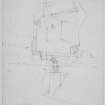
This structure occupies the whole summit of an isolated rock at the north corner of Ob (bay) Gauscavaig on the southern shore of the mouth of Loch Eishort. The rock is wholly precipitous and rises some 30 to 40 feet above the sea, which washes its base all round save towards the mainland, from which it is cut off by a steep gully or trench about 20 feet wide and 15 or 16 feet deep hewn out of the natural rock and strewn with angular pieces of stone debris. This gully is crossed by two arched walls, 6 feet apart, enclosing a space for a wooden drawbridge, 8 feet in length, to which there has been a levelled approach from the mainland defined by building at the margins. The arches spring from a built wall on the west and the natural rock on the mainland (Fig.272), the crowns rising to a height of 13 to 14 feet above the bottom of the trench, in which there is a considerable accumulation of stones directly beneath. At the inner extremity of the gap are the holes for the pivot upon which the drawbridge worked. Immediately beyond are the projecting checks for a door, which opened to a flight of stone steps turning to the left and rising 13 to 14 feet to the top. The higher part of this stair has disappeared, the upper entrance is undefined by any features, and the side walls of the staircase are much reduced at the lower levels. (Fig 275.)
It is clear that the whole summit of the rock measuring about 30 by 22 yards was originally enclosed by walling, of which portions varying in height still cling to the cliff edge and are shown on plan. About a third is completely gone or is buried under grassy mounds. The highest part remaining is in the south-east corner, where it rises at most to 16 or 17 feet. Where complete the surrounding wall averages 5 feet thick. There are only fragments of interior walling and no features worth noticing. The whole internal area is grass grown. An oblong building, 38 feet by 16 feet with 4½ feet walls, occupied the extreme western section, but its foundations are now defined only by grass-grown mounds. There is another but much more indefinite area on the north side. The position of a built well now filled with debris is given on plan. There seems to have been a garderobe in the north-east corner and in the south face a sea-gate.
The building is of the usual character in the western isles, random rubble roughly coursed in large irregular stones with much infilling of smaller material and plenty lime. The work on the bridge and stair looks later than that of the main structure and is not bonded into the latter at the place of junction. The building is in bad condition. As the mortar disintegrates under the influence of the sea air and wind, the stones at the foundations loosen and fall away, and the upper courses then collapse from their own weight.
HISTORICAL NOTE. Properly Dun Scaich is Dun Sgathaich, which explains the form in a charter of 1505, terrarum de Sleit una cum castro et fortalicio de Dunskahay (1). In Highland tradition it was the Dun of Scathach the martial instructress of the epic hero Cuchullin. There probably was a more ancient structure of the dun class. It was the principal seat of the Clan Huisdean or Macdonalds of Sleat. In 1515 there was a remission to Lauchlan Maclean of Dowart and Alistair Macleod of Dunvegan for assisting ‘in the tresonable segeing and taking of the Kingis castillis and hous of Carnebog and Dunskaith’ (2). The place was then in the King's hands by forfeiture. Monro refers to it in 1549 as ‘the castill of Dunskay, pertaining to the said Donald Gromsone’, that is Donald Macdonald Gormson of Sleat. An obligation by ‘Donald McDonill gorme’ (really the same Gormson, who died in 1573) of Jan. 1572-3 is dated at ‘Dounsceiche’ (3). Later on the Macdonalds of Sleat made Duntulm their chief residence (4).
RCAHMS 1928, visited 24 June 1921.
OS map: Skye li.
(1) R.M.S. II., No. 2873. (2) Reg. Sec. Sig. I., No. 2616. (3) Coll. de Reb. Alb., p. 11. (4) Cf. No. 538.
Publication Account (1985)
Dun Scaich or Dun Scaith is said to have been built in a single night by the fairies or by a witch. It was to this fortress that the hero Cuchulainn came for instruction in the arts of war by the warrior Queen Scathach according to legend. It is described as being surrounded by seven ramparts crowned by iron palisades and protected by a pit full of snakes and beaked toads! Whatever its traditional origin, the castle was used in late medieval times by the MacDonalds of Sleat.
The most impressive aspect of Dun Scaich is now its landward side, where the wall stands in places to a height of 5m. It is built upon a rock with precipitous sides, and approached by a causeway, partly natural, which leads to a bridge over a gully in the rock. The floor of the bridge is now missing. Beyond this a flight of steps climbs between walls to the entrance, to the left of which the wall stands to a considerable height; in the corner to the right there are the remains of a room incorporating a garderobe. The whole of the top of the rock was originally enclosed by a wall on all but the east side. Turf covered wall-bases or foundations show where some interior buildings stood. The break in the wall on the south side was probably a sea-gate. In the early 17th century the MacDonalds moved to Duntulm, in Trottemish (no. 26) but later returned to Sleat, to their new residence at Armadale (no. 1).
Information from ‘Exploring Scotland’s Heritage: Argyll and the Western Isles’, (1985).
Project (23 October 2010 - 12 November 2010)
A desk-based assessment and walkover survey were undertaken in advance of a proposed woodland management scheme. The work was undertaken to assess the nature and extent of any archaeology likely to be affected by the scheme and to inform recommendations for the protection and management of any sites. Several new sites were recorded during fieldwork.
Information from S. Birch - West Coast Archaeological Services, 2010.
OASIS ID: westcoas1-87220

