Field Visit


Date 24 June 1921
Event ID 1105123
Category Recording
Type Field Visit
Permalink http://canmore.org.uk/event/1105123
Dun Scaich.
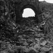
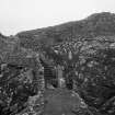
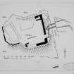
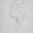
This structure occupies the whole summit of an isolated rock at the north corner of Ob (bay) Gauscavaig on the southern shore of the mouth of Loch Eishort. The rock is wholly precipitous and rises some 30 to 40 feet above the sea, which washes its base all round save towards the mainland, from which it is cut off by a steep gully or trench about 20 feet wide and 15 or 16 feet deep hewn out of the natural rock and strewn with angular pieces of stone debris. This gully is crossed by two arched walls, 6 feet apart, enclosing a space for a wooden drawbridge, 8 feet in length, to which there has been a levelled approach from the mainland defined by building at the margins. The arches spring from a built wall on the west and the natural rock on the mainland (Fig.272), the crowns rising to a height of 13 to 14 feet above the bottom of the trench, in which there is a considerable accumulation of stones directly beneath. At the inner extremity of the gap are the holes for the pivot upon which the drawbridge worked. Immediately beyond are the projecting checks for a door, which opened to a flight of stone steps turning to the left and rising 13 to 14 feet to the top. The higher part of this stair has disappeared, the upper entrance is undefined by any features, and the side walls of the staircase are much reduced at the lower levels. (Fig 275.)
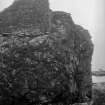
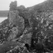
It is clear that the whole summit of the rock measuring about 30 by 22 yards was originally enclosed by walling, of which portions varying in height still cling to the cliff edge and are shown on plan. About a third is completely gone or is buried under grassy mounds. The highest part remaining is in the south-east corner, where it rises at most to 16 or 17 feet. Where complete the surrounding wall averages 5 feet thick. There are only fragments of interior walling and no features worth noticing. The whole internal area is grass grown. An oblong building, 38 feet by 16 feet with 4½ feet walls, occupied the extreme western section, but its foundations are now defined only by grass-grown mounds. There is another but much more indefinite area on the north side. The position of a built well now filled with debris is given on plan. There seems to have been a garderobe in the north-east corner and in the south face a sea-gate.
The building is of the usual character in the western isles, random rubble roughly coursed in large irregular stones with much infilling of smaller material and plenty lime. The work on the bridge and stair looks later than that of the main structure and is not bonded into the latter at the place of junction. The building is in bad condition. As the mortar disintegrates under the influence of the sea air and wind, the stones at the foundations loosen and fall away, and the upper courses then collapse from their own weight.
HISTORICAL NOTE. Properly Dun Scaich is Dun Sgathaich, which explains the form in a charter of 1505, terrarum de Sleit una cum castro et fortalicio de Dunskahay (1). In Highland tradition it was the Dun of Scathach the martial instructress of the epic hero Cuchullin. There probably was a more ancient structure of the dun class. It was the principal seat of the Clan Huisdean or Macdonalds of Sleat. In 1515 there was a remission to Lauchlan Maclean of Dowart and Alistair Macleod of Dunvegan for assisting ‘in the tresonable segeing and taking of the Kingis castillis and hous of Carnebog and Dunskaith’ (2). The place was then in the King's hands by forfeiture. Monro refers to it in 1549 as ‘the castill of Dunskay, pertaining to the said Donald Gromsone’, that is Donald Macdonald Gormson of Sleat. An obligation by ‘Donald McDonill gorme’ (really the same Gormson, who died in 1573) of Jan. 1572-3 is dated at ‘Dounsceiche’ (3). Later on the Macdonalds of Sleat made Duntulm their chief residence (4).
RCAHMS 1928, visited 24 June 1921.
OS map: Skye li.
(1) R.M.S. II., No. 2873. (2) Reg. Sec. Sig. I., No. 2616. (3) Coll. de Reb. Alb., p. 11. (4) Cf. No. 538.