
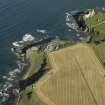
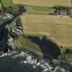
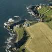
Tantallon, Gin Head, Admiralty Signals Establishment Extension


Building(S) (20th Century), Radar Station (20th Century)
Site Name Tantallon, Gin Head, Admiralty Signals Establishment Extension
Classification Building(S) (20th Century), Radar Station (20th Century)
Alternative Name(s) Taking Head; Defence Chain Home Low Radar Station
Canmore ID 113646
Site Number NT58NE 58
NGR NT 59301 85265
Datum OSGB36 - NGR
Permalink http://canmore.org.uk/site/113646


- Council East Lothian
- Parish North Berwick
- Former Region Lothian
- Former District East Lothian
- Former County East Lothian
NT58NE 58 59301 85265
See also NT58NE 59.
Site recorded during a rapid coastal survey undertaken by GUARD of the S shore of the Firth of Forth from Dunbar to Stirling and along the N shore of the Forth to the Fife border. A gazetteer of all sites including listed buildings, designed landscapes, scheduled and unscheduled monuments was produced. Full details of the survey can be consulted in the report held by the NMRS.
NT 590 852 Structures.
Sponsor: Historic Scotland
GUARD 1996
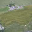
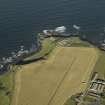
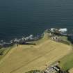
One upstanding building, and three partially sunken sheds with steps down or ramp entry, seen on 1946 aerial photographs. May be part of testing area for laboratory (explosive sheds), or part of WW2 defences. B108 7287-8 15/4/46.
Site recorded by GUARD during the Coastal Assessment Survey for Historic Scotland, 'The Firth of Forth from Dunbar to the Coast of Fife' 1996.
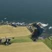
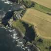
Built of brick and concrete and occupying the headland to the W of Tantallon Castle, this site was a Air Ministry and Admiralty Signals Establishment extension and was used for research.
J A Guy 1997; NMRS MS 810/5, 172-3
Information passed to RCAHMS would suggest that this establishment was not Air Ministry. A Coast DefenceD/Chain Home Low (CHL/CD) radar station with transmitting and receiving block.
Information via e-mails from Mr I Brown to RCAHMS, 19 October 1998; 21 October 2005.
In use by the Admiralty until 1984 when the site was sold to Ferranti's. Finally closed in 1994.
J Tully-Jackson and I Brown 1996.
The site was used to test naval radar and opened in 1943. Royal Navy radar testing base to ascertain effectiveness of countermeasures equipment. Closely associated with preparatory work for the Normandy landings in 1944 to test measures against German radar types. The base included equipment that could mimic a rolling ship.
Possibly used as a Coast Defence type of Chain Home radar.
Information from RCAHMS (DE), October 2009.
Field Visit (1996)
One upstanding building, and three partially sunken sheds with steps down or ramp entry, seen on 1946 aerial photographs. May be part of testing area for laboratory (explosive sheds), or part of WW2 defences. B108 7287-8 15/4/46.
Site recorded by GUARD during the Coastal Assessment Survey for Historic Scotland, 'The Firth of Forth from Dunbar to the Coast of Fife' 1996.
Archaeological Evaluation (August 2008)
NT 5931 8524 An evaluation was carried out in August 2008 prior to the conversion of buildings to residential use. The work followed on from a desk-based assessment and standing building recording undertaken in 2005. Five evaluation trenches were opened by mechanical excavator. The trenches covered 150m2, 5% of the accessible area of grass and light scrub. No significant archaeological remains were identified.
Archive: RCAHMS
Funder: Dunglass Limited
Richard Heawood (Abercorn Archaeology LLP), 2008

