Accessibility

Font Size

100% 150% 200%

Background Colour

Default Contrast
Close Reset

Churchill Barrier No. 2, Lamb Holm To Glimps Holm

Causeway (20th Century)

Site Name Churchill Barrier No. 2, Lamb Holm To Glimps Holm

Classification Causeway (20th Century)

Alternative Name(s) Scapa Flow; Churchill Causeway; Holm Sound

Canmore ID 112585

Site Number ND49NE 15

NGR ND 4804 9975

NGR Description ND 4822 9999 to ND 4785 9952

Datum OSGB36 - NGR

Permalink http://canmore.org.uk/site/112585

Ordnance Survey licence number AC0000807262. All rights reserved.
Canmore Disclaimer. © Bluesky International Limited 2025. Public Sector Viewing Terms

Toggle Aerial | View on large map

Digital Images

General oblique aerial view of The Bu, Burray, South Ronaldsay and Churchill Barrier No. 2, looking NNW.
General oblique aerial view of The Bu, Burray, South Ronaldsay and Churchill Barrier No. 2, looking NNW.Oblique aerial view from S, centred on the island of Glimp's Holm, and showing barrier No.3 in the centre left of the photograph. Barriers No's. 1 and 2 are visible in the top right-hand corner area.Oblique aerial view of Orkney, Burray, general view taken from the SSE of Burray, part of Burray village and the four Churchill Barriers.Oblique aerial view.Oblique aerial view from NE, centred on the Barrier, and showing the wreck of the blockship Elton in the centre left of the photograph, and traces of Air-raid Shelters and a Tramway on Glimps Holm in the top right-hand corner.Oblique aerial view from NNW, centred on the Barrier, and showing Lamb Holm quarry in the centre left of the photograph.Oblique aerial view from NW.  Visible are the Islands of Lamb Holm, Glimps Holm and Burray. The village of St Mary's is also visible.Oblique aerial view of Orkney, Burray, general view taken from the S of Burray, Burray village and all four Churchill Barriers.Oblique aerial view from E, centred on the Barrier, and showing the wreck of the blockship Elton in the centre left of the photograph, and traces of Air-raid Shelters and a Tramway on Glimps Holm in the top left-hand corner.Oblique aerial view from N.  Visible are the Islands of Lamb Holm, Glimps Holm and Burray.  Part of the village of St Mary's is also visible.General oblique aerial view centred on Lamb Holm airfield with the causeways adjacent, taken from the  NNE.Oblique aerial view of Burray with the Churchill Barriers and Mainland beyond, taken from the S.Causeways connecting Orkney mainland, with Burray via Lamb Holm and Glims Hold South Ronaldsay, Orkney, Scotland. Oblique aerial photograph taken facing North/East. Causeways connecting Orkney mainland, with Burray via Lamb Holm and Glims Hold South Ronaldsay, Orkney, Scotland. Oblique aerial photograph taken facing North/East. Oblique aerial view from SW, centred on Barrier No. 3 and showing the island of Glimp's Holm in the centre left of the photograph. Barriers No's. 1 and 2 are visible in the top right-hand corner area.General oblique aerial view centred on Lamb Holm airfield with the causeways adjacent, taken from the ENE.General oblique aerial view centred on Lamb Holm airfield with the causeways adjacent, taken from the NE.Oblique aerial view from N, centred on the Barrier and  the wreck of the blockship Elton.Oblique aerial view from N.  Visible are the Islands of Lamb Holm, Glimps Holm and Burray. The village of St Mary's is also visible.Oblique aerial view from N.  Visible are the Islands of Lamb Holm, Glimps Holm and Burray.  Part of the village of St Mary's is also visible.General oblique aerial view of St Mary's looking towards Glimps Holm and Churchill Barrier No. 2 with Burray and South Ronaldsay beyond, taken from the NNE.Oblique aerial view.Oblique aerial view from NNE, centred on the Barrier, and showing traces of Air-raid Shelters and a Tramway on Glimps Holm in the top right-hand corner. Barrier No. 3 is visible in the top half of the photograph.Oblique aerial view of Churchill Barrier No. 2, taken from the ESE.Oblique aerial view.Oblique aerial view from NE, centred on Barriers No. 2 and 3, and showing Lamb Holm quarry and Battery in the bottom left-hand corner of the photograph.Oblique aerial view of Orkney, Burray, general view taken from the S of Burray, Burray village and all four Churchill Barriers.Oblique aerial view of Burray with the Churchill Barriers and Mainland beyond, taken from the S.General oblique aerial view of The Bu, Burray, South Ronaldsay and Churchill Barrier No. 2, looking NNW.

Administrative Areas

  • Council Orkney Islands
  • Parish Holm
  • Former Region Orkney Islands Area
  • Former District Orkney
  • Former County Orkney

Archaeology Notes

ND49NE 15 4804 9975 (ND 4822 9999 to ND 4785 9952)

See also:

ND49NW 2 ND 4412 9670 to ND 4452 9641 Hunda Reef Barrier

HY40SE 25 HY 4840 0126 to HY 4848 0069 Churchill Barrier No. 1, Mainland to Lamb Holm (Kirk Sound)

ND49NE 16 ND 4730 9870 to ND 4744 9833 Churchill Barrier No. 3, Glimps Holm to Burray (Weddel Sound)

ND49NE 17 ND 4802 9543 to ND 4770 9495 Churchill Barrier No. 4, Burray To South Ronaldsay (Water Sound)

See also corresponding (predecessor) blockships:

ND49NE 8014 AC6

ND49NE 8015 Argyle

ND49NE 8016 Emerald Wings

ND49NE 8017 Rheinfeld

ND49NE 8018 Ilsenstein

ND49NE 8019 Elton

ND49NE 8020 Lycia

ND49NE 8021 Teeswood

ND49NE 8023 Cape Ortegal

HY40SE 8002 Rosewood

Churchill Causeway No 2 [NAT]

OS 1:10,000 map, 1985.

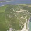
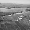
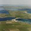
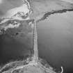
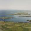
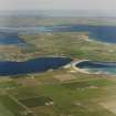
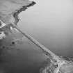
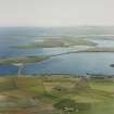
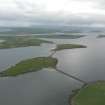
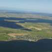
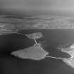
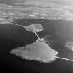
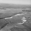
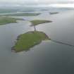
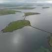
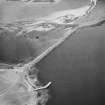
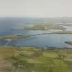
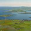
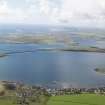
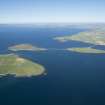
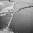
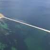
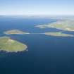
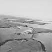
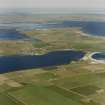
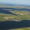
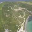
This causeway carries the A961 public road across Holm Sound, between Lamb Holm and Glimps Holm. Holm Sound is the second most northerly of the four sounds on the E side of Scapa Flow.

Information from RCAHMS (RJCM), 10 May 2006.

Activities

Watching Brief (8 August 2013 - 9 October 2013)

A watching brief undertaken on and at either end of The Churchill Barriers (Barriers 1, 2 and 4), and at West Greaves, Orkney as part of a Scottish Water pipe replacement and improvement scheme. 16 small trenches were monitored between July and October 2013. No features of archaeological interest were uncovered.

Information from L Somerville - Orkney Research Centre for Archaeology (ORCA).

OASIS ID: orkneyre1-166213

Laser Scanning (6 September 2013 - 18 December 2013)

A High Definition Laser Scan was undertaken by Orkney Research Centre for Archaeology (ORCA) Marine of the east side and top of Churchill Barrier 2 on behalf of Orkney Islands Council (OIC). A unified, edited pointcloud in Leica Cyclone format and PTS version for use in AutoCAD Civil 3D 2013. A report sets out the methodology used, the results, lessons learned and how the deliverables were created and edited for further use by OIC.

Mark Littlewood 2013.

OASIS ID: orkneyre1-194664

References

MyCanmore Image Contributions


Contribute an Image

MyCanmore Text Contributions