
Inverpeffer


Farmhouse (Period Unassigned), Farmstead (Period Unassigned), Rig And Furrow (Medieval) - (Post Medieval)
Site Name Inverpeffer
Classification Farmhouse (Period Unassigned), Farmstead (Period Unassigned), Rig And Furrow (Medieval) - (Post Medieval)
Alternative Name(s) East Haven Airfield
Canmore ID 112338
Site Number NO63NW 17
NGR NO 600 377
Datum OSGB36 - NGR
Permalink http://canmore.org.uk/site/112338


- Council Angus
- Parish Panbride
- Former Region Tayside
- Former District Angus
- Former County Angus
NO63NW 17 600 377
See also NO53NE 59 (East Haven Airfield).
See also NO63NW 22 and NO63NW 23.
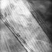
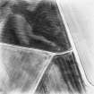
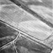
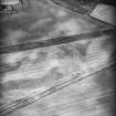
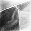
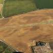
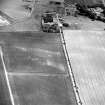
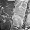
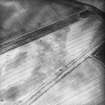
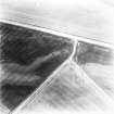
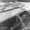
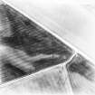
Aerial photography has revealed the linear cropmarks of Inverpeffer farmhouse and farmsteading, and associated features, 300m SE of Inverpeffer. It is depicted as three large roofed buildings with a courtyard, seven outbuildings, a pigeon house and gardens on the 1st edition of the OS 6-inch map (Forfarshire 1865, sheet lii), and is as extensive on the revised 2nd edition map (Forfarshire 1923, sheets lii.5 and lii.6). It was demolished in 1941/42 to allow the construction of East Haven Airfield (NO53NE 59), although was still visible on a World War Two vertical photograph (RAF D309, 5010, flown 1941). A pair of parallel linear cropmarks, about 12m apart, and visible in a large arc from NO c.6010 3770 to NO c.6002 3754, are of a trackway which ran SW from the farmsteading, and a further set of parallel linear features immediately to the E (NO63NW 22) may be further traces of gardens and trackways. Rig runs NW - SE to the W of the farmsteading, and immediately to the south of the trackway, which it does not repect. These cropmarks were previously interpretated as linear cropmarks and cultivation remains.
Information from RCAHMS (KB) 27 May 1999

