
Pricing Change
New pricing for orders of material from this site will come into place shortly. Charges for supply of digital images, digitisation on demand, prints and licensing will be altered.
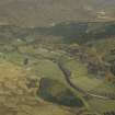
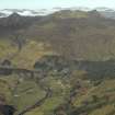
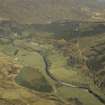
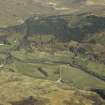
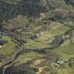
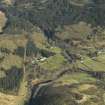
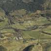
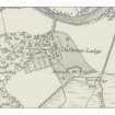
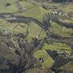
Dalbreac Lodge


Golf Course (Period Unassigned), Lodge (Period Unassigned), Turf Bank (Period Unassigned)
Site Name Dalbreac Lodge
Classification Golf Course (Period Unassigned), Lodge (Period Unassigned), Turf Bank (Period Unassigned)
Canmore ID 111496
Site Number NH35SW 4
NGR NH 3034 5489
Datum OSGB36 - NGR
Permalink http://canmore.org.uk/site/111496


- Council Highland
- Parish Contin
- Former Region Highland
- Former District Ross And Cromarty
- Former County Ross And Cromarty
NH35SW 4.00 3034 5489
NH35SW 4.01 3032 5486 Gamekeeper's House
NH35SW 4.02 3030 5488 Offices
ARCHITECTS: Ross & Macbeth (I.C. 16 Oct 1891) Additions
Srp Note (14 January 2011)
This summary record incorporates NOSAS site survey numbers 1158 - 1160. Further details of these and other associated sites can be found in the Strathconon Phase 3 Report (page 52) produced by the North of Scotland Archaeology Society and appended to this record.
Lodge, earthbank, and golf tees (NOSAS survey site Nos 1158 – 1160) - centred on NH 3035 5484
1158 Lodge - NH 30319 54945 (NMRS No - NH35SW 004) Low moss covered stoney mounds mark the site of this Lodge which was burnt to the ground in 1941. A rockery and walkways to the west are overgrown with rhododendrons. To the SW a walled garden marked on the old estate plan of 1850 and the 1st edition OS survey has been levelled and replaced by a yard and sheds
1159 Earth bank - NH 30291 54775 (corner) In a field to the SW of the old lodge a possible pair of parallel turf banks run in a N-S alignment, 5.5m apart. The east most of the two and the most obvious is 0.5m high x 1.5m spread and 29m length, it turns at its N end and runs NE for a short distance.
1160 Platforms/Golf tees - centred on NH 3035 5481 There are 3 raised platforms in the field to the south of the lodge; local information has it that they were tees for a golf course.
A - NH 30333 54788 Rectangular 3m x 5m x 0.3m high (a few metres to east a turf bank 2m spread x 17m length
B - NH 30350 54843 4m square x 0.5m high
C - NH 30370 54809 4m square x 0.5m high

