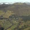
 |
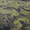
On-line Digital Images |
DP 024953 |
RCAHMS Aerial Photography Digital |
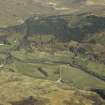
Oblique aerial view centred on the country house, watermill, road bridge and township, taken from the NW. |
4/4/2007 |
Item Level |
|
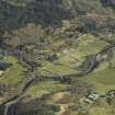 |
On-line Digital Images |
DP 024955 |
RCAHMS Aerial Photography Digital |
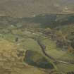
General oblique aerial view centred on the country house, watermill, road bridge and township, taken from the SW. |
4/4/2007 |
Item Level |
|
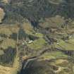 |
On-line Digital Images |
DP 024956 |
RCAHMS Aerial Photography Digital |
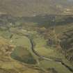
General oblique aerial view centred on the country house, watermill, road bridge and township, taken from the S. |
4/4/2007 |
Item Level |
|
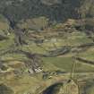 |
On-line Digital Images |
DP 024957 |
RCAHMS Aerial Photography Digital |
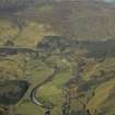
General oblique aerial view centred on the country house, watermill, road bridge and township, taken from the S. |
4/4/2007 |
Item Level |
|
 |
On-line Digital Images |
DP 024959 |
RCAHMS Aerial Photography Digital |
General oblique aerial view centred on the country house, watermill, road bridge and township, taken from the S. |
4/4/2007 |
Item Level |
|
 |
On-line Digital Images |
DP 024960 |
RCAHMS Aerial Photography Digital |
General oblique aerial view centred on the country house, watermill, road bridge and township, taken from the SE. |
4/4/2007 |
Item Level |
|
 |
On-line Digital Images |
DP 024961 |
RCAHMS Aerial Photography Digital |
General oblique aerial view centred on the country house, watermill, road bridge and township, taken from the SE. |
4/4/2007 |
Item Level |
|
 |
On-line Digital Images |
DP 024965 |
RCAHMS Aerial Photography Digital |
General oblique aerial view looking towards Sgurr a¿ Mhuilinn centred on the country house, watermill, road bridge and township with the church in the foreground, taken from the E. |
4/4/2007 |
Item Level |
|
 |
On-line Digital Images |
DP 024966 |
RCAHMS Aerial Photography Digital |
General oblique aerial view looking towards Sgurr a¿ Mhuilinn centred on the country house, watermill, road bridge and township, taken from the E. |
4/4/2007 |
Item Level |
|
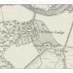 |
On-line Digital Images |
DP 091894 |
Records from North of Scotland Archaeological Society (NOSAS), Highland, Scotland |
1st edition of the OS 6-inch map (Ross-shire 1881, sheet lxxxvi) extract |
14/1/2011 |
Item Level |
|
 |
Digital Files (Non-image) |
WP 000352 |
Records from North of Scotland Archaeological Society (NOSAS), Highland, Scotland |
Strathconon Phase Three Report - Loch Meig to Dalbreac |
21/1/2011 |
Item Level |
|


