 |
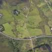
On-line Digital Images |
DP 094781 |
RCAHMS Aerial Photography Digital |
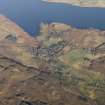
Oblique aerial view of the township, looking SSW. |
31/8/2010 |
Item Level |
|
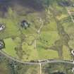 |
On-line Digital Images |
DP 094782 |
RCAHMS Aerial Photography Digital |
Oblique aerial view of the township, looking SSW. |
31/8/2010 |
Item Level |
|
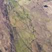 |
On-line Digital Images |
DP 109317 |
RCAHMS Aerial Photography Digital |
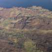
General oblique aerial view of the remains of a farmstead, field system, head dykes and lazy beds at Allt An Loin Ruaidh, looking toward the remains of the townships of Suladale and Clachamish, Skye, taken from the S. |
30/4/2011 |
Item Level |
|
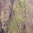 |
On-line Digital Images |
DP 109318 |
RCAHMS Aerial Photography Digital |
Oblique aerial view of the remains of a farmstead, field system, head dykes and lazy beds at Allt An Loin Ruaidh, looking toward the remains of the townships of Suladale and Clachamish, Skye, taken from the SSE. |
30/4/2011 |
Item Level |
|
 |
On-line Digital Images |
DP 111362 |
RCAHMS Aerial Photography Digital |
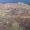
Oblique aerial view of the remains of the townships of Knott, Clachamish, Tayinloan, Suladale and the remains of Dun Suladale broch, Skye, taken from the SSW. |
16/11/2011 |
Item Level |
|
 |
On-line Digital Images |
DP 111363 |
RCAHMS Aerial Photography Digital |
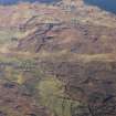
General oblique aerial view of the remains of the townships of Clachamish and Treaslane and the nearby remains of field systems and lazy beds, Skye, taken from the SW. |
16/11/2011 |
Item Level |
|
 |
On-line Digital Images |
DP 111364 |
RCAHMS Aerial Photography Digital |
General oblique aerial view of the remains of the townships of Clachamish and Treaslane and the nearby remains of field systems and lazy beds, Skye, taken from the SW. |
16/11/2011 |
Item Level |
|
 |
On-line Digital Images |
DP 111365 |
RCAHMS Aerial Photography Digital |
General oblique aerial view of the remains of the townships of Clachamish and Treaslane and the nearby remains of field systems and lazy beds, Skye, taken from the SW. |
16/11/2011 |
Item Level |
|
 |
On-line Digital Images |
SC 2359061 |
Records of the Ordnance Survey, Southampton, Hampshire, England |
Clachamish, Skye, NG35SE 5, Ordnance Survey index card, Recto |
1958 |
Item Level |
|
 |
On-line Digital Images |
SC 2359062 |
Records of the Ordnance Survey, Southampton, Hampshire, England |
Clachamish, Skye, NG35SE 5, Ordnance Survey index card, page number 1, Recto |
1958 |
Item Level |
|
|
All Other |
551 166/1/1 |
Records of the Ordnance Survey, Southampton, Hampshire, England |
Archaeological site card index ('495' cards) |
1947 |
Sub-Group Level |
|


