Accessibility

Font Size

100% 150% 200%

Background Colour

Default Contrast
Close Reset

Clachamish, Skye

Township (Period Unassigned)

Site Name Clachamish, Skye

Classification Township (Period Unassigned)

Canmore ID 11146

Site Number NG35SE 5

NGR NG 383 533

Datum OSGB36 - NGR

Permalink http://canmore.org.uk/site/11146

Ordnance Survey licence number AC0000807262. All rights reserved.
Canmore Disclaimer. © Bluesky International Limited 2025. Public Sector Viewing Terms

Toggle Aerial | View on large map

Digital Images

Oblique aerial view of the township, looking SSW.
Oblique aerial view of the township, looking SSW.General oblique aerial view of the remains of a farmstead, field system, head dykes and lazy beds at Allt An Loin Ruaidh, looking toward the remains of the townships of Suladale and Clachamish, Skye, taken from the S.Oblique aerial view of the remains of the townships of Knott, Clachamish, Tayinloan, Suladale and the remains of Dun Suladale broch, Skye, taken from the SSW.Oblique aerial view of the township, looking SSW.Oblique aerial view of the remains of a farmstead, field system, head dykes and lazy beds at Allt An Loin Ruaidh, looking toward the remains of the townships of Suladale and Clachamish, Skye, taken from the SSE.General oblique aerial view of the remains of the townships of Clachamish and Treaslane and the nearby remains of field systems and lazy beds, Skye, taken from the SW.General oblique aerial view of the remains of the townships of Clachamish and Treaslane and the nearby remains of field systems and lazy beds, Skye, taken from the SW.Clachamish, Skye, NG35SE 5, Ordnance Survey index card, RectoGeneral oblique aerial view of the remains of the townships of Clachamish and Treaslane and the nearby remains of field systems and lazy beds, Skye, taken from the SW.Clachamish, Skye, NG35SE 5, Ordnance Survey index card, page number 1, Recto

Administrative Areas

  • Council Highland
  • Parish Snizort
  • Former Region Highland
  • Former District Skye And Lochalsh
  • Former County Inverness-shire

Archaeology Notes

NG35SE 5 383 533.

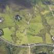
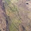
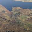
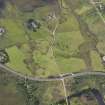
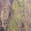
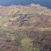
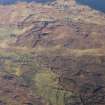
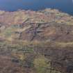
NG 383 533. Clachamish, a modern settlement, incorporates the remains of a depopulated township comprising about 12 ruined houses with outhouses and enclosures. (Visible on RAF air photographs CPE/Scot/UK/175: 2233-4)

Visited by OS (A S P) 23 April 1961.

A township, comprising fourteen roofed buildings and two unroofed buildings is depicted on the 1st edition of the OS 6-inch (Inverness-shire, Isle of Skye 1881, sheet xvi). Three roofed buildings and fifteen unroofed buildings are shown on the current edition of the OS 1:10560 map (1969).

Information from RCAHMS (AKK) 17 October 1996.

References

MyCanmore Image Contributions


Contribute an Image

MyCanmore Text Contributions