 |
On-line Digital Images |
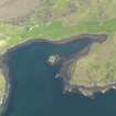
DP 076586 |
RCAHMS Aerial Photography Digital |
Oblique aerial view centred on the fort and buildings, taken from the WNW. |
31/5/2009 |
Item Level |
|
 |
On-line Digital Images |
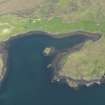
DP 076587 |
RCAHMS Aerial Photography Digital |
Oblique aerial view centred on the fort and buildings, taken from the W. |
31/5/2009 |
Item Level |
|
 |
On-line Digital Images |
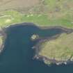
DP 076588 |
RCAHMS Aerial Photography Digital |
Oblique aerial view centred on the fort and buildings, taken from the WSW. |
31/5/2009 |
Item Level |
|
 |
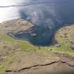
On-line Digital Images |
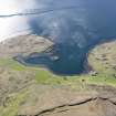
DP 109325 |
RCAHMS Aerial Photography Digital |
General oblique aerial view of the remains of the fort at Dun Maraig and the remains of the township, field system, enclosures and lazy beds at Cuidrach, Skye, taken from the E. |
30/4/2011 |
Item Level |
|
 |
On-line Digital Images |
DP 109326 |
RCAHMS Aerial Photography Digital |
General oblique aerial view of the remains of the fort at Dun Maraig and the remains of the township, field system, enclosures and lazy beds at Cuidrach, Skye, taken from the E. |
30/4/2011 |
Item Level |
|
|
Manuscripts |
MS 36/66 |
Records of the Royal Commission on the Ancient and Historical Monuments of Scotland (RCAHMS), Edinbu |
Field notebook of J G Callander (RCAHMS). Titled 'Skye, Barra, South Uist, Benbecula, 1915'. |
24/5/1915 |
Item Level |
|
 |
On-line Digital Images |
SC 2358998 |
Records of the Ordnance Survey, Southampton, Hampshire, England |
Dun Maraig, Skye, NG35NE 5, Ordnance Survey index card, Recto |
c. 1958 |
Item Level |
|
 |
On-line Digital Images |
SC 2358999 |
Records of the Ordnance Survey, Southampton, Hampshire, England |
Dun Maraig, Skye, NG35NE 5, Ordnance Survey index card, page number 1, Recto |
c. 1958 |
Item Level |
|
 |
On-line Digital Images |
SC 2359000 |
Records of the Ordnance Survey, Southampton, Hampshire, England |
Dun Maraig, Skye, NG35NE 5, Ordnance Survey index card, page number 2, Verso |
c. 1958 |
Item Level |
|
|
All Other |
551 166/1/1 |
Records of the Ordnance Survey, Southampton, Hampshire, England |
Archaeological site card index ('495' cards) |
1947 |
Sub-Group Level |
|


