
Unst, Mailand


Burnt Mound (Prehistoric)
Site Name Unst, Mailand
Classification Burnt Mound (Prehistoric)
Alternative Name(s) Mailland; Murrister
Canmore ID 111
Site Number HP60SW 11
NGR HP 60683 01457
Datum OSGB36 - NGR
Permalink http://canmore.org.uk/site/111


- Council Shetland Islands
- Parish Unst
- Former Region Shetland Islands Area
- Former District Shetland
- Former County Shetland
Field Visit (4 May 1969)
At HP 6068 0148 is a burnt mound, about 11.0m diameter,about 0.5m high, hollowed out revealing two large stones, and cut by a ditch.
Surveyed at 1/2500.
Visited by OS(RL) 4 May 1969
Desk Based Assessment (1969)
HP60SW 11 6068 0146
HP 605 018 (C S T Calder 1965) A burnt mound, now destroyed, at Mailand.
RCAHMS 1946, visited 1933.
Information from OS Index Card.
Field Visit (29 April 2010)
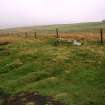
This burnt mound stands in the NE corner of a field some 235m NW of Murrister farmsteading (HP60SW 175). C-shaped on plan with a hollow in its NNE side, the mound measures about 7.8m from ENE to WSW by 5.9m transversely and 0.5m in height, but it has been truncated slightly on the NNE by a drain. The mound has evidently been robbed and two large stones lie exposed in a hollow at the centre. Erosion of the surface of the mound has revealed a mass of reddened, fire-cracked, angular fragments of stone within a matrix of loose, black soil.
Visited by RCAHMS (ARG) 29 April 2010.

