
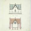
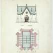
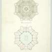
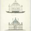
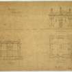
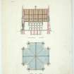
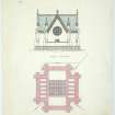
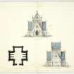
Forglen House, Mausoleum


Boundary Wall (19th Century), Gate(S) (19th Century), Mausoleum (19th Century)
Site Name Forglen House, Mausoleum
Classification Boundary Wall (19th Century), Gate(S) (19th Century), Mausoleum (19th Century)
Alternative Name(s) Forglen House Policies; Forglen Mausoleum With Boundary Retaining Walls, Railings, Gates And Gatepiers
Canmore ID 110814
Site Number NJ65SE 30.07
NGR NJ 69851 51085
Datum OSGB36 - NGR
Permalink http://canmore.org.uk/site/110814


- Council Aberdeenshire
- Parish Forglen
- Former Region Grampian
- Former District Banff And Buchan
- Former County Banffshire
NJ65SE 30.07 69851 51085
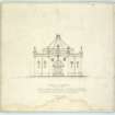
Air photography (AAS/96/17/G, flown 10 September 1996) has recorded this Gothic building in a forest clearing.
Information from Aberdeenshire Archaeological Service, October 1996.
NMRS, MS/712/12.

