
Pricing Change
New pricing for orders of material from this site will come into place shortly. Charges for supply of digital images, digitisation on demand, prints and licensing will be altered.
Upcoming Maintenance
Please be advised that this website will undergo scheduled maintenance on the following dates:
Thursday, 30 January: 11:00 AM - 3:00 PM
During these times, some functionality such as image purchasing may be temporarily unavailable. We apologise for any inconvenience this may cause.
Skye, Dun Beag, Struanmore


Broch (Iron Age), Armlet(S) (Glass)(Period Unassigned)
Site Name Skye, Dun Beag, Struanmore
Classification Broch (Iron Age), Armlet(S) (Glass)(Period Unassigned)
Alternative Name(s) Struan
Canmore ID 11062
Site Number NG33NW 3
NGR NG 33951 38634
Datum OSGB36 - NGR
Permalink http://canmore.org.uk/site/11062


First 100 images shown. See the Collections panel (below) for a link to all digital images.
- Council Highland
- Parish Bracadale
- Former Region Highland
- Former District Skye And Lochalsh
- Former County Inverness-shire
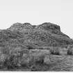
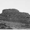
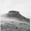
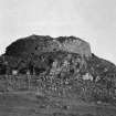
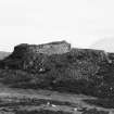
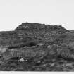
Dun Beag, late first millennium bc Iron Age broch showing evidence of reuse in the early medieval period; excavated 1914 -20. Skye's answer to Dun Carloway, with gallery, cell and stairway surviving between inner and outer battered drystone walls.
Taken from "Western Seaboard: An Illustrated Architectural Guide", by Mary Miers, 2008. Published by the Rutland Press http://www.rias.org.uk

NG33NW 3 3395 3861
See also NG33NW 4.
NG 3395 3861 Dun Beag (NR)
OS 6" map, Inverness, 2nd ed., (1904)
Dun Beag is a broch near Struan and is situated at the N end of a small rocky eminence about 200ft above sea level. Access to it is from the S as for more than half its diameter on the N side it is within 4ft of the rocky edge. The broch was excavated from 1914 to 1920 by Countess Vincent Baillet de Latour, FSA Scot.
The inner court is circular and the diameter is 35ft. The outside diameter is about 60ft. The doorway faces slightly S of E, just where the wall curves inwards from the edge of the plateau.
In the interior, 16ft of wall facing SW was found in the NE sector, and a network of drains at various levels. These seem to be of later date as nearly all the finds were at the lowest levels.
Structures described by Pennent (Pennent 1776) and Dr. Johnson, (see R W Chapman 1924) in 1772 or 1773, in the centre, were evidently of a later date and have disappeared.
As no definite layers of occupation were encountered, it is possible that the broch was used until comparatively recently. The erection and disappearance of these later buildings, sweeping away previous secondary buildings, seems to bear this out, as does the discovery of coins of Henry II, Edward I, James VI (Scots), George II and George III.
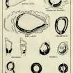
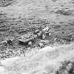
Other finds included many stone implements and utensils, a gold ring, bronze objects, a piece of folded sheet lead, iron and glass objects, a borer of bone, a pick made from an antler, much pottery and a stone cup. An armlet of glass covered with vitreous paste of different colours is similar to examples found in the lowest levels of Traprain Law (NT57SE 1) dated to probably about 100 AD. A complete crucible is almost identical with one found in the group of earth-houses at Foshigarry, N Uist.
The character of the ornamentation of a bronze buckle is more Scandinavian than Celtic and gold rings similar to the one found here have been found with Viking remains.
Considerable quantities of cattle and sheep bones were found and a cake of carbonised seeds, probably either oats or rye.
Several hundred glass beads found cannot be considered prehistoric relics.
T Pennant 1776; J G Callender 1921; R W Chapman 1924; RCAHMS 1928; A Graham 1949.
Broch as described by Callender. Condition good. There are about 6 ruined houses to the N and E.
Visited by OS (C F W) 10 April 1961.
Field Visit (11 June 1921)
Dun Beag, Struanmore.
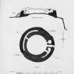
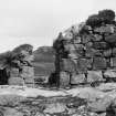
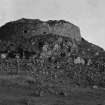
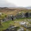
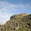
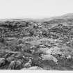
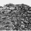
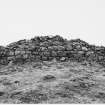
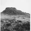
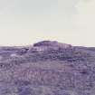
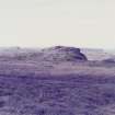
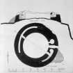
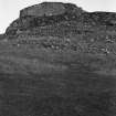
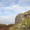
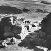
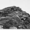
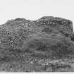
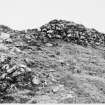
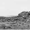
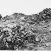
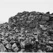
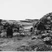
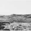
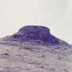
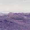
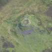
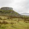
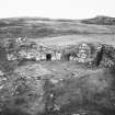
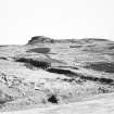
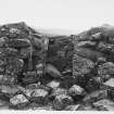
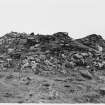
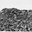
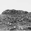
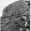
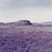
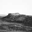
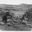
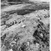
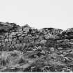
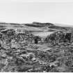
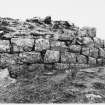
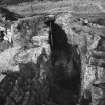
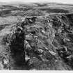
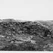
On one of the numerous rocky flat-topped eminences on the rough rising ground overlooking Loch Bracadale from the east, some 500 yards north-west of the school at Struanmore, and about ¾ mile from the sea-shore, at an elevation of about 200 feet above sea-level, are the ruins of Dun Beag, one of the best preserved brochs in Skye. It occupies the north-western end of a small irregular plateau which rises about 12 feet above a hollow intervening between it and the hill country to the north-east; in the opposite direction the ground falls away in a steep descent towards the sea, and round the north-western extremity is a rocky bluff, with a stony talus chiefly formed of stones fallen from the walls about 30 feet in height. The broch, which is erected within a few feet of the edge of the rock, is circular in shape and has an external diameter of 62 feet. (Fig. 205.)
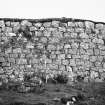
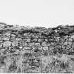
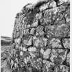
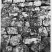
Except at the north-east, where it has been torn down, the outer face of the building remains in a fine state of preservation, showing excellent drystone masonry formed of blocks laid in regular courses; the interior face is irregularly coursed of rougher material. From the north to the west the walls show in places a height of 11 and 12 feet, the courses being almost 1 feet thick on average ; on the southern arc the blocks of stone are generally larger and the wall seems to be about 8 feet in height. The wall varies from 11 ½ feet to 13 feet 9 inches in thickness.
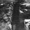
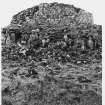
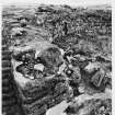
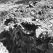
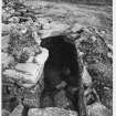
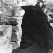
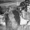
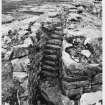
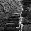
The entrance lies to the east ; a fine slab forms the threshold of the passage-way which, much broken down, measures 3 feet in width outside and 4 feet 3 inches inwards ; it is widened by door checks 8 inches deep on each side, from which it narrows to 2 feet 11 inches inside. A lintelled doorway, 1 foot 6 inches wide, 2 feet 2 inches deep, and 3 feet northwards from the entrance inside, leads from the court into an almost circular beehive cell measuring from 6 feet 2 inches to 6 feet 7 inches in diameter. Another doorway, with the inner lintel stone in position and leading into a gallery in the wall, is situated 7 feet south of the entrance and is 2 feet 8 inches in width at the outside, 3 feet on the inside, 5 feet in length, and 5 feet 7 inches in height under the lintel. Immediately to the north, the gallery terminates in an oval chamber measuring 4 feet 7 inches by 6 feet 2 inches and5 feet 6 inches in height, with the roof beehived, but to the south it contains 20 steps of a stair. Two lintels remain in position above the gallery at the left side of the entrance, and one above the stair. At the top of the staircase the gallery is about 2 feet 3 inches wide, the wall on the inside 5 feet and on the outside 6½ feet. Diametrically opposite in the north-western arc an opening in the inner wall 2 feet 7 inches wide, 5 feet 3 inches long, with sill raised 2 feet 3 inches above the rough surface of the interior, has given access to a second gallery with ends lost in debris, but still measuring 50 feet in length and 2 feet 2 inches in width. (Figs. 202-4.)
During excavation in 1915 by the Countess Vincent Baillet de Latour, F.S.A. Scot., part of a rough wall abutting on the inside of the main wall to the north-west and extending towards the centre was laid bare but is now removed. About 18 inches from the top was a mass of red burnt earth, the debris of a peat fire, indicating that the superstructure was of later date. About 5 feet 6 inches from the foundation of the wall towards the south-west was a thin layer of periwinkle shells indicating a late level of occupation. There were also remains of peat fires close to the small shell layers. A miscellaneous collection of relics, some of comparatively recent date, were recovered during the course of the excavation (1).
The outer wall has a batter, and in the first four or five courses the face of the upper stone is laid about 1 inch inwards from that of the stone below it.
RCAHMS 1928, visited 11 June 1921.
OS map: Skye xxviii.
(1) See further Proc. Soc. Ant. Scot., Vol. LV.,pp. 110-31.
Publication Account (2007)
NG33 3 DUN BEAG
NG/340386 (GPS NG/3401 3856)
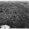
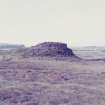
This ground-galleried broch in Bracadale, Skye, stands in a commanding position, on a steep-sided rock knoll on relatively low, undulating moorland (visited 20/4/63, in 1985 and in 2003); it is only about 200m from the old road from which it could be clearly seen and it overlooks the sea and tracts of agricultural land.
1. Introduction
The broch was excavated by the Countess Vincent Baillet de Latour and the work lasted from 1914 until 1920. Although the standard of recording and publication was low even for that date a careful search seems to have been made for finds even though these could not be related to any site stratigraphy. Some 200 tons of earth and stones were removed from the broch and all the soil was sifted through the excavators' fingers. Also the Countess evidently hoped to discover a sequence of floor levels inside (see “The excavations” below).
2. History of visits to the site
A local resident informed Callender [4] that much damage had been done to the structure in the middle of the 19th century at which time the lintels over the entrance passage had been removed. This story of destruction seems to be confirmed by Pennant's account which says –
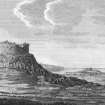
"Within are the vestiges of five apartments, one in the centre" (presumably the central court) "four around; the walls are eighteen feet high." [2, 202 and pl. xxxvi] (vol. 1, Illus. 3.5).
However in the following year a broch near Ullinish – which must be Dun Beag – was visited by Dr Samuel Johnson and James Boswell and the former described the wall as having a height of only 9 feet (2.75m) [3, 64]. The discrepancy illustrates how difficult it is to rely on the measurements of 18th century travellers who rarely say whether they were making estimates of dimensions by eye or whether they carried a tape measure. In fact the figure given by Pennant (who seems to have carried a tape) seems to match his drawing which shows the maximum wall height as about a third of the total diameter 18.6m (61 ft) in places, that is about 6.1m (20 ft).
Even if one makes allowances for the tendency of early illustrators to exaggerate the vertical scale, a height of at least 3.67-4.58m (12-15 ft) in 1772 seems indicated. Since the wall is now not much above 1.83m [6 ft) high it is clear that the broch has lost at least a half of its wall height during the last 230 years. This must mean that Dun Beag was once a true broch tower, with at least one upper intra-mural gallery, and probably at least part of a second, still remaining in 1772. By 1985 the wallhead had been turfed over by the then Scottish Development Department (now Historic Scotland)which has also erected a notice. By 2003 there was an excellent path to the site from a convenient parking place on the main road.
3. The structure
The outer face is exceptionally well built of rectangular and square blocks of stone skilfully fitted together with the minimum of pinning. This kind of care in selecting and fitting facing stones is extremely unusual in brochs outside the sandstone areas of Caithness and Orkney and suggests a particularly high status site. The outer face also shows a marked batter. Where it has fallen away the rubble core can be seen and this too seems to have been unusually well and carefully laid; there are few signs of this core collapsing outwards.
Level 1: the entrance, on the east-south-east, faces the edge of the knoll and is difficult to get into; it is 3.91m (13 ft) in length and 91cm (3 ft) wide at the outer end where there is a large threshold stone. A door-frame formed of built rebates or checks is at 4.33m (4 ft 5in) from the exterior; the rebates are 17.5 and 20.0cm (7 and 8in) deep. The passage then expands to 1.28m (4 ft 3in), decreasing again to 90cm (3 ft) at the inner end. No bar-holes are now visible and there are no guard cells. The passage is paved with stone slabs. As noted above, the passage seems to have retained its roofing lintels until about the mid 19th century [4]; in 1772 Samuel Johnson noted that "the entrance is covered with flat stones and is narrow."
The central court is clear of debris and very nearly circular [4, 113], having a diameter of 10.78m (35 ft 4in); there is a large, rather uneven area of rock outcrop in the middle [9, 883, plan] and Swanson points out that this feature implies the existence of a level, raised wooden floor [9, 881]. On the other hand the high level of the sill of the gallery door at 1.30 o'clock (below) could suggest that the primary floor of the interior was made up to this height, which is also about the height of the top of the rock outcrop; presumably there would then have been steps up to it from the entrance passage. The excavators could well have removed such floor packing without recognising its significance.
No trace of a scarcement was observed by the author on the inner wallface which nowhere now stands more than about 1.8m high. Swanson however says that a fragment of it is still visible on the south-west arc, its width being about 40 cm. She also refers to the remains of a raised door at about 1.30 o'clock which leads into the gallery at about scarcement level (which would therefore have been in Level 2), but may be confusing this with the (now buried) raised gallery door in Level 1 at the same point (below).
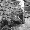
At 5.30 o'clock there is a round mural cell in the position of a guard cell but with its door leading into the central court. On the opposite side of the entrance, at just beyond 7 o'clock, is the doorway to the intra-mural stair which rises to the right; a stair-foot guard cell opens to the left. Both these cells are round-ended with traces of a corbelled beehive roof, but both have lost most of their domes. When first exposed the stair had 21 steps rising 2.4m (8 ft) over 3.3m (11 ft), that is at an angle of 36 degrees; 13 steps are visible now. The average height of the risers is 10cm (4.5in) and the average width of the steps 15cm (6in). There are now only 13 steps.
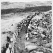
On the opposite side of the court, at about 1 o'clock, is the slightly raised doorway to the mural gallery; the latter appears to run right round the wall from below the stair at 8 o'clock as far as the cell at 5 o'clock. When first exposed the doorway was carefully blocked with good masonry (see Dun Ardtreck – NG33 1). The raised sill of this door is level with the rocky outcrop in the central court but is 73cm (2 ft 5in) above the floor of the gallery. The opening is now hidden under debris.
The gallery itself varies in width from 60 - 75cm (2-2.5 ft) and its walls remain standing to a height of 1.35m (4 ft 6 in). It was not completely cleared by the excavators at either end for fear of collapse. At present (2003) it is about half full of debris and the irregular surface formed by this is turfed.
Levels 2 and 3: there may be traces of an upper gallery at about 5 o'clock, at a height of about 2.15m (7 ft) above the floor, but no flooring lintels can be seen. As noted the 18th century records imply that at least one and perhaps two upper galleries were preserved in 1772 but no details of these can be recovered.
4. The excavations
Before the Countess' excavations began there were 1.2 - 1.8m (4 - 6 ft) of debris inside the broch, the cells and entrance passage. It was hoped that distinct occupation levels would be found inside the building, especially near the floor [4]. However the interior had evidently been much disturbed in later times; regular networks of stone-built drains were found at all levels in the fill in which there were also many layers of red peat ash. A crude secondary wall, faced on only one side, was found in the north-east sector; the core of this included deposits of ash and sherds implying that the debris round about was used to build it. The mural gallery was full of earth with many animal bones. In the 18th century there were evidently traces of round stone structures in the central court [2, 3] and these doubtless belong to one of these later periods of occupation.
The south part of the central court had a pavement of slabs which evened off the floor to the level of the rock outcrop.
5. Discussion
The information from the excavation of this broch is not detailed enough to allow any confident inferences about whether the broch had a primary and a secondary occupation, or whether the high, hollow wall was largely pulled down at some stage. These possibilities do exist, but mainly because of evidence from other sites. The fact that the interior seems to have been comprehensively disturbed in later times probably means that any internal stratigraphy had already been destroyed.
One clue may be relevant however; the gallery door was carefully blocked with walling when it was found. This almost certainly means that – as at Dun Ardtreck (NG33 2) – the upper walls of the broch were pulled down at some stage, filling the lowest gallery with rubble which was retained by this blocking.
Using this one small clue, and evidence from other better excavated sites, could infer that some of the Iron Age pottery and relics found in Dun Beag belong to a secondary phase of occupation, probably a fter part of the upper wall of what is assumed to have been a tower had been pulled down; the fill of earth and bone refuse in the mural gallery also suggests this. However the Iron Age pottery forms a homogeneous collection so – even though some of it apparently came from under paving at a low level – it cannot be used by itself to suggest an earlier and a later occupation.
It is also obvious that a variety of later occupations took place inside the ruined broch, perhaps during the Norse period [10, fig. 45, no. 15] and certainly during historic times.
6. The finds:
Most of the Iron Age pottery and nearly all the other ancient relics were found at the lowest level inside the broch, sometimes under the paving. By contrast there were many fragments of craggans, a relatively recent pottery style, at various higher levels of the central court. There was an almost complete absence of horn and bone tools.
Iron implements included fragments of slag, 1 tanged knife 12cm (4.75 in) long, and a possible spearhead 8cm (3.25 in) long.
Copper alloy included 2 rings, 1 thin, oval, penannular wire ring (possibly from a loose-ring-headed pin), and 4 bronze pins. There were also several crucibles, round or conical of which only 1 was complete, and some stone moulds (below).
Gold: 1 flattened ring was found about 91cm (3 ft) high in the debris, and there was also 1 small strip.
Lead: a small piece of sheet lead was found (if ancient this should indicate some kind of Roman contact).
Bone and antler: the only bone tools were 1 wedge-shaped awl or borer and 1 pick of red deer antler with all the tines cut off.
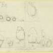
Stone artifacts included about 20 hammerstones, 2 whetstones, 1 thin polished disc (the upper side polished), 1 ground disc of dark micaceous stone (both faces and edges ground: diameter 8.5cm); 1 rough disc (diameter 8.2cm), probably a pot-lid, 1 handled cup of steatite, 8 grooved pebble strike-a-lights with signs of use with iron strikers, 10 whorls, several of steatite, 1 ball 3.8cm in diameter with a deep hole 7 mm in diameter drilled into it, 1 pear-shaped pendant, 10 fragmentary upper and lower stones of rotary querns, 1 miniature rotary quern, 3 moulds for casting bronze bars or ingots (one cut into a rotary quern fragment), and several pumice fragments, one with sharpening grooves.
Glass objects included several hundred globular beads, some plain and others in various shades of blue, amber, red, green and white; they were not thought to be prehistoric though, oddly, most were found near the bottom of the debris inside the broch. There were several other beads including two – dark and milky-blue respectively – with inlays of white and yellow respectively; 1 armlet fragment of Iron Age type was found at the lowest level, D-shaped in section and made of translucent green glass with an external coat of opaque milky white and inlaid with three narrow bands of yellow.
Pottery: the Iron Age pottery from this site has recently been discussed by MacSween [10] but the absence of any except the most general stratigraphical information inhibits any useful interpret-ation unless the evidence from other sites is considered. MacSween's analysis is hampered by her not considering the evidence of the long and reasonably well dated ceramic sequence from Dun Mor Vaul, Tiree, published twenty-nine years earlier (site NM04 4: MacKie 1965a and 1974). It consists of a mixture of plain and decorated wares, the latter mostly having patterns of incised lines and looking like Vaul ware vases. One or two cordoned sherds, and at least one rim, of Everted Rim ware are present. A complete base sherd shows a pattern of finger-impressions on the inside surface. The plain ware appears mainly to be of Vaul ware vases but one unusual fine, barrel-shaped vessel is present.
7. Dimensions [5]
External diameter c. 18.61m (61 ft), internal 10.68m (35 ft 0in), very close to the 1971 survey figure given below; the wall base varies from 3.66 - 4.17m (12 ft -13 ft 8in) and the wall proportion is therefore c. 42.5%. In 1971 an angle and distance survey of the inner wallface was undertaken with a theodolite and steel tape. The central court proved to be very close to an exact circle [4, 113] with a radius of 5.39 +/- 0.05 m, equivalent to a diameter of 10.78m (35 ft 4in).
Sources: 1. NMRS site no. NG 33 NW 31: 2. Pennant 1790, [5th edn.), pt. 2, 292 and pl. xxxvii: 3. Chapman, ed., 1970, 64-65: 4. Callender 1921: 5. RCAHMS 1920, 142-43, no. 479, and figs. 201-04: 6. Graham 1947, 97: 7. Young 1962, 188, no. 43: 8. MacSween 1984-85, 41, no. 4 and fig. 4: 9. Swanson 1985 (ms), 880-83 and plan: 10. MacSween 2002.
E W MacKie 2007
External Reference (2011)
Evidence for later re-use of the broch in the late Viking/Norse period consists of a gold finger ring, bronze stick-pins, an ornamented belt buckle, a coin of Henry II (1154-89), and pottery (Graham-Campbell, James and Batey, Colleen E 1998, 78; illustrated in Callander 1920-21, p. 124). The gold ringer ring is formed from a plain band that tapers to rounded terminals. It is one of three gold finger rings found on Skye (Graham-Campbell 1995).
Information from the ARCH Community Timeline course, 2011

