Field Visit


Date 11 June 1921
Event ID 1104384
Category Recording
Type Field Visit
Permalink http://canmore.org.uk/event/1104384
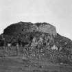
Dun Beag, Struanmore.
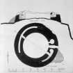
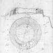
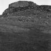
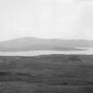
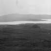
On one of the numerous rocky flat-topped eminences on the rough rising ground overlooking Loch Bracadale from the east, some 500 yards north-west of the school at Struanmore, and about ¾ mile from the sea-shore, at an elevation of about 200 feet above sea-level, are the ruins of Dun Beag, one of the best preserved brochs in Skye. It occupies the north-western end of a small irregular plateau which rises about 12 feet above a hollow intervening between it and the hill country to the north-east; in the opposite direction the ground falls away in a steep descent towards the sea, and round the north-western extremity is a rocky bluff, with a stony talus chiefly formed of stones fallen from the walls about 30 feet in height. The broch, which is erected within a few feet of the edge of the rock, is circular in shape and has an external diameter of 62 feet. (Fig. 205.)
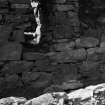
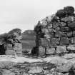
Except at the north-east, where it has been torn down, the outer face of the building remains in a fine state of preservation, showing excellent drystone masonry formed of blocks laid in regular courses; the interior face is irregularly coursed of rougher material. From the north to the west the walls show in places a height of 11 and 12 feet, the courses being almost 1 feet thick on average ; on the southern arc the blocks of stone are generally larger and the wall seems to be about 8 feet in height. The wall varies from 11 ½ feet to 13 feet 9 inches in thickness.
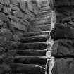
The entrance lies to the east ; a fine slab forms the threshold of the passage-way which, much broken down, measures 3 feet in width outside and 4 feet 3 inches inwards ; it is widened by door checks 8 inches deep on each side, from which it narrows to 2 feet 11 inches inside. A lintelled doorway, 1 foot 6 inches wide, 2 feet 2 inches deep, and 3 feet northwards from the entrance inside, leads from the court into an almost circular beehive cell measuring from 6 feet 2 inches to 6 feet 7 inches in diameter. Another doorway, with the inner lintel stone in position and leading into a gallery in the wall, is situated 7 feet south of the entrance and is 2 feet 8 inches in width at the outside, 3 feet on the inside, 5 feet in length, and 5 feet 7 inches in height under the lintel. Immediately to the north, the gallery terminates in an oval chamber measuring 4 feet 7 inches by 6 feet 2 inches and5 feet 6 inches in height, with the roof beehived, but to the south it contains 20 steps of a stair. Two lintels remain in position above the gallery at the left side of the entrance, and one above the stair. At the top of the staircase the gallery is about 2 feet 3 inches wide, the wall on the inside 5 feet and on the outside 6½ feet. Diametrically opposite in the north-western arc an opening in the inner wall 2 feet 7 inches wide, 5 feet 3 inches long, with sill raised 2 feet 3 inches above the rough surface of the interior, has given access to a second gallery with ends lost in debris, but still measuring 50 feet in length and 2 feet 2 inches in width. (Figs. 202-4.)
During excavation in 1915 by the Countess Vincent Baillet de Latour, F.S.A. Scot., part of a rough wall abutting on the inside of the main wall to the north-west and extending towards the centre was laid bare but is now removed. About 18 inches from the top was a mass of red burnt earth, the debris of a peat fire, indicating that the superstructure was of later date. About 5 feet 6 inches from the foundation of the wall towards the south-west was a thin layer of periwinkle shells indicating a late level of occupation. There were also remains of peat fires close to the small shell layers. A miscellaneous collection of relics, some of comparatively recent date, were recovered during the course of the excavation (1).
The outer wall has a batter, and in the first four or five courses the face of the upper stone is laid about 1 inch inwards from that of the stone below it.
RCAHMS 1928, visited 11 June 1921.
OS map: Skye xxviii.
(1) See further Proc. Soc. Ant. Scot., Vol. LV.,pp. 110-31.