
Following the launch of trove.scot in February 2025 we are now planning the retiral of some of our webservices. Canmore will be switched off on 24th June 2025. Information about the closure can be found on the HES website: Retiral of HES web services | Historic Environment Scotland
Skye, Annait, Bay River


Cemetery (Post Medieval), Fort (Prehistoric) - (Early Medieval), Monastic Settlement (Early Medieval)(Possible), Shieling Hut(S) (Medieval) - (Post Medieval)
Site Name Skye, Annait, Bay River
Classification Cemetery (Post Medieval), Fort (Prehistoric) - (Early Medieval), Monastic Settlement (Early Medieval)(Possible), Shieling Hut(S) (Medieval) - (Post Medieval)
Alternative Name(s) Fairy Bridge
Canmore ID 10918
Site Number NG25SE 1
NGR NG 2724 5272
Datum OSGB36 - NGR
Permalink http://canmore.org.uk/site/10918


- Council Highland
- Parish Duirinish
- Former Region Highland
- Former District Skye And Lochalsh
- Former County Inverness-shire
NG25SE 1 272 527
(NG 2721 5272) Annait (NR) Burial Ground
OS 6" map, Inverness-shire, 2nd ed., (1904)
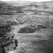
Annait lies in the sharp angle formed by the confluence of the Bay River and a small affluent on the left bank about a mile from its mouth. It takes the form of a long narrow triangle, the sides of which rise from 20' to 50' above the bed of both streams in steep slopes and almost inaccessible rocky scarps. It measures fully 200' in length and 165' across the base, where it is cut off from gradually rising moorland to the S by a wide natural hollow about 12' deep. The ruins of a stone wall standing to a height of 3' at most and showing several courses of drystone building, crown the N edge of the hollow, and this wall has been continued along the E side on the edge of the bank rising from the river. On the W boundary there remains no trace of a wall or parapet, but this side is much more difficult of access. There is a well-defined entrance through the basal wall on the S near its W end, measuring some 6'6" in width, the wall on its E side showing a thickness of 18'.
Within the thickness of the wall between the entrance and its E end are indications of four chambers, possibly the ruins of domed cells. These are oval in shape, except the most easterly example, which is circular on plan and the best defined of the group. To the N of the last chamber are a few scattered stones with five blocks set on edge forming the N arc of a circular building. On the top and in the centre of this portion of the wall are the foundations, c. 5' thick, of a later rectangular building, 23'6" x 11'6", lying N-S with the N end projecting into the enclosure. To the N and in line with this building are the stone foundations about 3' thick of two smaller structures, the southern of which has apparently been divided into two compartments. Beyond these again are indications of two hut circles. Near the W edge of the enclosure and about 75' N of the main wall is an oblong stone foundation, possibly a church, oriented E-W and measuring 18' x 8' internally. The thickness of the wall is clearly defined at the W end and measures 4' at the foundation.
In the hollow and 25' outside the gateway are the stone foundations of 3 impinging oval cells placed in an L-shaped position, and foundations of another secondary building, measuring 29' x 13'6" within 4'6" thick walls, projecting SW from the outer face of the main wall near its E end.
Bodies of unchristened children were buried within this enclosure down to 25 years ago. (RCAHMS 1928)
Boswell (F A Piottle and C H Bennett 1955), who visited the site in 1773, notes an eastern rampart extending across the neck of the promontory to the S of the stone wall.
MacCulloch (J A MacCulloch 1948) refers to Boswell and interprets the site as a fort later occupied as a monastic establishment.
The name Annait probably indicates, as in Ireland, the mother church or monastic community of the earliest Christian settlement of the district.
A MacBain 1922; W J Watson 1926; RCAHMS 1928; J A MacCulloch 1948; F A Pottle and C H Bennet 1955.
This site is not a cashel in the proper sense which, by Irish analogies, ought to be round or oval and consist of a wall without a ditch. The conclusion reached is that the church had been planted in an earlier fort.
Information contained in letter from C Thomas to OS, 27 April 1961.
Annait, an early monastic establishment, generally as described and planned by the RCAHMS, occupying part of an earlier fort.
An entrance, obscured by debris, can be seen in the N wall of the chapel.
An elongated triangle on plan, the fort measures 140.0m N-S by c. 50.0m maximum width internally, with the wall 5.6m thick at the entrance, 2.0m wide, in the S. The wall stands to a height of c. 1.5m in the S, and the outer face and some of the wall core can be traced intermittently along the E side, but along the W side where most of it has apparently disappeared over the cliff, it can only be seen towards the N end. Forty-six metres S of the fort, a turf-covered tumbled wall spread to 3.5m cuts off the promontory. This is undoubtedly the "rampart" noted by Boswell. There is no definite trace of an entrance, and, although it may be a late dyke, its condition and position suggest it is more likely the precinct wall of the monastic establishment.
Between this wall and the fort is the natural hollow described by the RCAHMS. On its inner lip in the W is a rampart mutilated by the insertion into it of two cells, and on its outer lip are another two ramparts. It is uncertain if these ramparts represent an earlier work, or outworks of the stone fort.
Through these two outer ramparts has been driven a way c. 8.0m wide which leads onto an expanding causeway built up over the natural gully. The construction of this, together with a rectilinear stone walled enclosure on its E side, has probably destroyed the E extent of the inner rampart.
Visited by OS (AA), 21 October 1971.
Field Visit (8 June 1921)
Annait.
The enclosure known as Annait lies about 2¾ miles north-east of Dunvegan Castle, and barely 1 mile north by west of the Fairy Bridge on the Portree and Dunvegan road, in the sharp angle formed by the confluence of Bay River and a small affluent on the left bank about a mile from its mouth. It takes the form of a long narrow triangle, the sides of which rise from 20 to 50 feet above the bed of both streams in steep slopes and almost inaccessible rocky scarps. The enclosure measures fully 200 feet in length and 165 feet across the base, where it is cut off from gradually rising moorland to the south by a wide natural hollow about 12 feet deep. The ruins of a stone wall standing to a height of 3 feet at most and showing several courses of drystone building, crown the northern edge of the hollow, and this wall has been continued along the eastern side on the edge of the bank rising from the river. On the western boundary there remains no trace of a wall or parapet, but this side is much more difficult of access. There is a well defined entrance through the basal wall on the south near its western end, measuring some 6 feet 6 inches in width, the wall on the eastern side showing a thickness of 18 feet. Within the thickness of the wall between the entrance and its eastern end are indications of four chambers, possibly the ruins of domed cells. These are oval in shape, except the most easterly example, which is circular on plan and is the best defined of the group. To the north of the last chamber are a few scattered stones with five blocks set on edge forming the northern arc of a circular building. On the top and in the centre of this portion of the wall are the foundations, about 5 feet thick, of a later rectangular building 23 feet 6 inches long and 11 feet 6 inches wide internally, lying north and south with the northern end projecting into the enclosure. To the north and in line with this building are the stone foundations, about 3 feet thick, of two smaller structures, the southern of which has apparently been divided into two compartments. Beyond these again are indications of two hut circles. Near the western edge of the enclosure and about75 feet north of the main wall is an oblong stone foundation, possibly a church, orientated east and west and measuring 18 feet in length and 8 feet in breadth internally. The thickness of the wall is clearly defined in the western end, and measures 4 feet at the foundation.
In the hollow and 25 feet outside the gateway are the stone foundations of three impinging oval cells placed in an L-shaped position, and foundations of another secondary building, measuring 29 feet long and 13 feet 6 inches wide internally, with walls 4 feet 6 inches thick, projecting south-westerly from the outer face of the main wall near its eastern end.
Bodies of unchristened children were buried within this enclosure down to twenty-five years ago.
RCAHMS 1928, visited 8 June 1921.
OS map: Skye xv.
Field Visit (22 June 1990)
This fort, situated on a promontory between the gorges of the Bay River and a major tributary running into its W side, just S of their confluence, measures 130m from N to S by 50m transversely within stone walls, which are best preserved on the S, but poorly preserved on the N, E and W sides, where they may have collapsed into the gorge below. The stone walls, where best preserved are 5m thick, 43m long and up to 1.2m in height with four courses of facing-stones still visible defending the S approaches to the promontory. Towards the W end there is an entrance, 1.9m in width, faced with orthostatic stones, and there are indications of set stones on the top of the wall, suggesting the presence of an interior gallery 2m in breadth. The wall is reduced to 2.5m in thickness at its W end and it is poorly preserved at the E. The reduced wall stands up to three courses high (1.3m) at the N end, where it is best preserved. In front of the S rampart at an oblique angle to it and running from WNW to ESE, is a second, and possibly earlier, defensive line of large stones. The outer walls mentioned in the OS report of 1971 are set across the neck of the promontory to the S, cut by a levelled ramp 8m in width, appears to be natural. The bank, which runs across the promontory beyond them, is a field-bank rather than 'the precinct wall of the monastic establishment' (OS (AA) 21 October 1971). A group of shieling-huts occupies the site. This comprises three buildings, two multi-celled huts, one of them on a mound, and an enclosure. One of the buildings is set across the S rampart (WAT90 1131); it measures 6.7m from N to S by 3.2m transversely within rubble-faced walls 0.9m in thickness and 0.6m in height. A second is built against the front of the same rampart (WAT90 1132) and measures 8.2m from N to S by 3.4m transversely within rubble-faced walls 1.3m in thickness and 0.6m in height. The third building (WAT90 1128) is situated some 25m N of the entrance to the fort and measures 5.8m from E to W by 2.5m transversely within rubble-faced walls 0.9m in thickness and 0.7m in height, with an entrance in the N side. In front of the entrance to the fort is a subrectangular mound (WAT90 1129), measuring 7.8m from E to W by 4.8m transversely, on which is a two-celled hut with an outshot, attached to the N side of the W cell. The larger E cell measures 2.3m by 1.4m, with an outshot of similar size. The other two-celled hut (WAT90 1130) lies a few metres N of the building, which is set across the rampart, its W, or larger, cell measures 3m from N to S by 1.6m transversely within rubble-faced walls 1.3m in thickness and 0.6m in height.
(WAT90 1128-1132)
Visited by RCAHMS (PJD), 22 June 1990.
Note (14 January 2015 - 18 May 2016)
Known by tradition as Annait, a place-name with ecclesiastical associations, this fortification occupies a promontory formed between the gorges of the Bay River and one of its tributaries. There are traces of rubble along the flanks of the promontory, particularly on the E, but the principal defences comprise a wall 43m long blocking access from a shallow saddle on the S. The wall here is up to 5m thick and in places still stands 1.2m high in four course, but there are also traces on this side of a second line of defence set at a slight angle to it, though its comparatively poor state of preservation more probably suggests that it represents an earlier phase of fortification. The entrance, which is 1.9m wide and faced with orthostats, lies towards the W end of the main wall, where several stones set in the body of the wall-core may indicate the presence of some internal structure, such as a gallery; beyond the entrance the wall appears to reduce in thickness. The interior measures about 130m from N to S by up to 50m transversely (0.6ha). Apart from elements of a more extensive group of shielings that clearly overlie the defences, the interior is featureless.
Information from An Atlas of Hillforts of Great Britain and Ireland – 18 May 2016. Atlas of Hillforts SC2692

