
Stromeferry, General


Village (Period Unassigned)
Site Name Stromeferry, General
Classification Village (Period Unassigned)
Canmore ID 109151
Site Number NG83SE 13
NGR NG 863 346
Datum OSGB36 - NGR
Permalink http://canmore.org.uk/site/109151


- Council Highland
- Parish Lochalsh
- Former Region Highland
- Former District Skye And Lochalsh
- Former County Ross And Cromarty
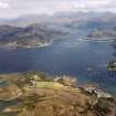
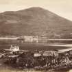
Stromeferry Viewed across Loch Carron by the old Macdonell stronghold of Strome Castle, this was for long an important crossing point and ferry terminal, with a pier of 1814 serving the Parliamentary road from Achnasheen. In 1870, Strome became the railhead for the Dingwall and Skye Railway, which was extended to Kyle of Lochalsh in 1897 after extensive works had been carried out to blast through the solid rock. The track was repositioned in 1971, when a new road was built along the old line. Station building now demolished.
Taken from "Western Seaboard: An Illustrated Architectural Guide", by Mary Miers, 2008. Published by the Rutland Press http://www.rias.org.uk


