Accessibility

Font Size

100% 150% 200%

Background Colour

Default Contrast
Close Reset

Morar, Falls Of Morar Viaduct

Railway Viaduct (19th Century)

Site Name Morar, Falls Of Morar Viaduct

Classification Railway Viaduct (19th Century)

Alternative Name(s) River Morar; Cnoc Drochaid; Morar Viaduct

Canmore ID 108547

Site Number NM69SE 15

NGR NM 68131 92238

Datum OSGB36 - NGR

Permalink http://canmore.org.uk/site/108547

Ordnance Survey licence number AC0000807262. All rights reserved.
Canmore Disclaimer. © Bluesky International Limited 2025. Public Sector Viewing Terms

Toggle Aerial | View on large map

Digital Images

General view of viaduct from west south west (with Falls of Morar in foreground)
General view of viaduct from west south west (with Falls of Morar in foreground)Oblique aerial view of Morar looking towards Loch Eilt centred on the railway viaduct and the new and old road bridges, taken from the W.Morar, Falls of Morar Viaduct over River Morar
Detailed view from east of south arch and abutment.  Note that the south pier is moulded around a rock outcropThe railway viaduct, MorarMorar, Falls of Morar Viaduct over River Morar
General view of viaduct from south west (also showing 1897 date plaque)Morar, Falls of Morar Viaduct over River Morar
General view of viaduct from west south west (with Falls of Morar in foreground)Oblique aerial view looking along the River Morar across the bridges, taken from the WSW.Morar, Falls of Morar Viaduct over River Morar
Detailed view from east of south arch and abutment.  Note that the south pier is moulded around a rock outcropAerial view of Morar, Wester Ross, looking W.Morar, Falls of Morar Viaduct over River Morar
View of viaduct from eastOblique aerial view.Morar, Falls of Morar Viaduct over River Morar
General view of viaduct from south west (also showing 1897 date plaque)Oblique aerial view looking along the River Morar across the bridges, taken from the W.General oblique view of Morar, looking to the E.An oblique aerial view of Morar Bay, Wester Ross, looking SE.Morar, Falls of Morar Viaduct over River Morar
View of viaduct from eastOblique aerial view centred on the railway viaduct with the new and old road bridges adjacent, taken from the NW.General oblique view of Morar, looking to the E.Morar, Falls of Morar Viaduct over River Morar
Oblique view from south east of north half of viaductOblique aerial view centred on the railway viaduct with the new and old road bridges adjacent, taken from the NNE.Oblique aerial view centred on the railway viaduct with the new and old road bridges adjacent, taken from the N.General oblique aerial view looking towards Loch Eilt centred on the railway viaduct and the new and old road bridges, taken from the W.Morar, Falls of Morar Viaduct over River Morar
Oblique view from south east of north half of viaductOblique aerial view.Oblique aerial view centred on the railway viaduct with the new and old road bridges adjacent, taken from the E.Oblique aerial view centred on the railway viaduct with the new and old road bridges adjacent, taken from the W.

Administrative Areas

  • Council Highland
  • Parish Arisaig And Moidart
  • Former Region Highland
  • Former District Lochaber
  • Former County Inverness-shire

Archaeology Notes

NM69SE 15 68131 92238

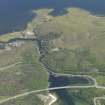
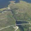
This viaduct carries the Fort William (Mallaig Junction) - Mallaig line (the 'West Highland extension') of the former North British Rly over the River Morar. The river here forms the boundary between the parishes of Glenelg, and Arisaig and Moidart.

Information from RCAHMS (RJCM), 27 August 1998.

This RCAHMS photographic survey was undertaken in order to enhance and augment the National Monuments Record Scotland holdings.

Visited by RCAHMS(MKO), July 1997.

Activities

Aerial Photography (3 May 2007)

References

MyCanmore Image Contributions


Contribute an Image

MyCanmore Text Contributions