
Following the launch of trove.scot in February 2025 we are now planning the retiral of some of our webservices. Canmore will be switched off on 24th June 2025. Information about the closure can be found on the HES website: Retiral of HES web services | Historic Environment Scotland
Quarry Hill


Quarry(S) (Period Unassigned)
Site Name Quarry Hill
Classification Quarry(S) (Period Unassigned)
Alternative Name(s) Birch Cottage; The Broom
Canmore ID 108142
Site Number NJ42NE 103
NGR NJ 485 252
NGR Description NJ 485 252 to NJ 492 255
Datum OSGB36 - NGR
Permalink http://canmore.org.uk/site/108142


- Council Aberdeenshire
- Parish Auchindoir And Kearn
- Former Region Grampian
- Former District Gordon
- Former County Aberdeenshire
NJ42NE 103 485 252 to 492 255
Quarries (disused) [NAT] (at NJ 486 252)
Quarries (dis) [NAT] (at NJ 491 254)
OS 1:10,000 map, 1972.
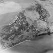
These quarries span the boundary between the parishes of Auchindoir and Kearn (to the W) and Rhynie (to the E).
Information from RCAHMS (RJCM), 9 October 1996.
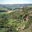
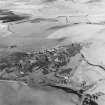
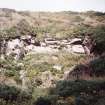
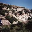
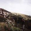
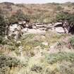
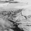
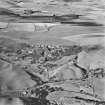
Sandstone has been quarried extensively on the steep SE flank of Quarry Hill above the A97 public road between Lumsden and Rhynie. The quarries are first mentioned here in the Statistical Account and the workings are depicted on the 1st edition of the OS 6-inch map (Aberdeenshire, 1870, sheet xlii). By this date the quarry comprised two main workings. The first was a long trench extending from NE to SW for a distance of about 380m immediately below the summit of the hill. It contained two buildings, one of them unroofed by 1870, and was approached by two tracks from the SW. The second working was a roughly oval-shaped pit situated lower down the slope to the E. It contained three roofed buildings and was approached by two tracks, one from the NE, the other from the SW. No trace of any of these buildings now survive.
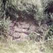
The expansion of the quarrying at the end of the 19th century is evident from a comparison of the 1st and 2nd editions of the OS 6-inch map (1902, sheet xlii.SE), showing that the SW end of the upper quarry was extended downslope to the SE. A new building was constructed at this time on the SE edge of the quarry and a track from the SW replaced the uppermost track shown on the 1st edition map. The lower quarry, within which two new buildings were erected, was also extended, and the construction of Birch Cottage (NJ42NE 142) necessitated the realignment of the track from the SW. Again, no trace of these buildings can be seen, but at the NE end of the lower quarry a stone-revetted loading ramp survives. The quarries were abandoned in the 1930s and are now overgrown, the lower working now lying in woodland. The final extent of the quarrying is depicted on the 1970 OS 1:2500 map (NJ48/25).
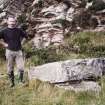
A headstone in the burial-ground of Auchindoir Church (NJ42SE 1) commemorates the death of William Smith, who was accidentally killed at the quarry on 10 November 1853.
Visited by RCAHMS (ARG), 6 September 1996.
OSA 1794.

