
Drumbowie, Ryding Heavy Anti Aircraft Battery


Anti Aircraft Battery (20th Century)
Site Name Drumbowie, Ryding Heavy Anti Aircraft Battery
Classification Anti Aircraft Battery (20th Century)
Alternative Name(s) N12; Clyde Aa Defences; Clyde Postwar Aa Defences; Drumbowie Farm; Glemavis; Drunbowie; Glenmavis
Canmore ID 107534
Site Number NS76NE 24
NGR NS 7515 6902
NGR Description Centred NS 7515 6902
Datum OSGB36 - NGR
Permalink http://canmore.org.uk/site/107534


- Council North Lanarkshire
- Parish New Monkland (Monklands)
- Former Region Strathclyde
- Former District Monklands
- Former County Lanarkshire
NS76NE 24 centred 7515 6902
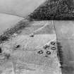
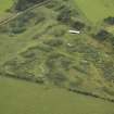
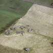
NS 7515 6901. This World War II heavy anti-aircraft battery is situated to the W of Drunbowie [Drumbowie] Farm and N of Glemavis [Glenmavis]. Four concrete gun-emplacements, command post, engine room, computing room and the hut bases of the crew accommodation camp are all extant.
J Guy 2001; NMRS MS 810/11, Part 3, 248-9; Vol.2 (appendix), 25.
National Archive records record this battery as having been unarmed throughout the war (1942-1945, WO 166/11169; WO 166/16650),
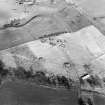
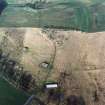
This battery has additions relating to the development of anti-aircraft defences in the postwar period. The postwar changes and additions are visible on vertical air photographs taken in 1945, 1947 and 1955.
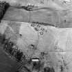
The remains of the anti aircraft battery are visible on vertical air photographs taken in 1945 (106g/UK/1028, frame 4335, flown 26 November 1945), which appear to confirm the lack of use through the war period, as the gun emplacements would appear to be heavily overgrown, though the camp retains a few upstanding huts as is the radar Gl-mat. By the date of the 1947 photographs however (CPE/Scot/UK 269, frames 5232-5233, Pt II, flown 15 August 1947), the site would appear to have cleared of vegetation as the four gun emplacements and command centre are clearly visible. In addition, though the accommodation camp is only visible as hut bases and the Gl-mat as a concrete ramp with a trench leading away to the S, no alterations would appear to have been made by August 1947.
The images from 1955 (F22 82/RAF/1236, frames 0240-0241, flown 11 July 1955), clearly show that between 1947 and 1955, several new buildings had been added and additions made to the gun emplacements. Two new flat roofed buildings are visible, one on the site of the Gl-mat area, to the W along with three flat roofed buildings immediately E of the site of the accommodation camp. It is these that are visible on the most recent oblique aerial views (RCAHMS 2007).
The evidence would appear to suggest that this battery was being developed from an existing WW II AA site possibly as part of the post war Rotor programme, under Army AA Command.
Information from RCAHMS (DE), May 2008; Information to RCAHMS via e-mail from Mr J Bamber, May 2008
Field Visit (21 June 2017)
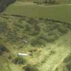
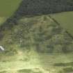
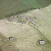
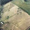
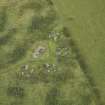
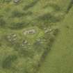
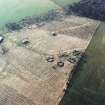
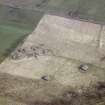
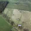
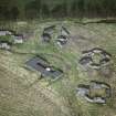
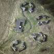
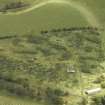
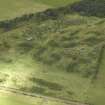
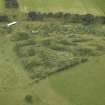
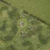
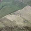
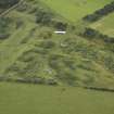
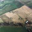
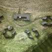
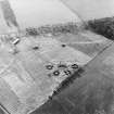
This heavy anti-aircraft battery, which is situated in open ground about 400m WSW of Drumbowie Farm, comprises four gun emplacements, a Second World War command post, a Cold War engine house, a Cold War command post and traces of at least thirty-one other buildings that once formed part of the associated camp. It was one of at least 43 such batteries that were constructed to protect the industries in the centre of Glasgow and along the banks of the River Clyde from aerial attack by the Luftwaffe during WWII. However, only the command post and the camp buildings formed part of this battery, all the remaining buildings having been introduced when this later became one of at least 78 heavy anti-aircraft gun emplacements that were deployed to counter the threat from the Soviet Union during the Cold War c.1950-56 (WO106/5912).
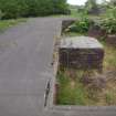
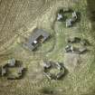
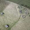
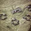
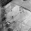
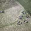
The battery is approached from the Condorat public road by a length of track that passes through cast concrete gateposts (NS 74625 68868) that are probably contemporary with the first military installations on the site, while the track itself includes fragments of asphalt, indicating that it may have been metalled originally. This runs for about 350m from WSW to ENE, before passing through a second pair of concrete gate posts (NS 74998 68916) and entering a piece of rough ground enclosing much of the camp, where its surface becomes grass-grown. At this point the track veers NE for 160m to arrive at the entrance of a roughly triangular security-fenced enclosure of 0.5ha containing the gun emplacements and the command post. This gateway (NS 75128 68980) is still marked by two tall, square-sectioned, cast concrete posts, while the fence posts are only a little less robust. Short spurs extending from the track once served each of the gun-pits, which are all planned around the circumference of a circle with radius of 35m pivoted on a WNW to ESE axis.
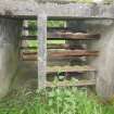
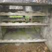
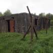
The four gun-pits (NS 75163 69049, NS 75180 69026, NS 75174 68997, NS 75149 68983), rebuilt on the site of the World War Two predecessors, are all of the same design - each being part-buried in an earthen bund. They are octagonal on plan and measure 13m in diameter within reinforced cast concrete blast walls 0.3m thick and 1.7m high. Opposed double gateways 3.5m wide occupy two sides. Drilled perforations in these walls held fittings for the attachment of camouflage netting, while pipes at their foot, passing through the walls at right angles, perhaps permitted rain water to drain away. In each gun-pit, four ammunition lockers measuring 3.6m by 1.75m internally within walls 0.15m thick and 1.65m high, are built against the inner side of the blast wall. All are symmetrically arranged in pairs to face one another, with raised floors, open ends and flat concrete roofs that commonly bear traces of bitumen. Many of the wooden racks with which they were fitted survive and these indicate that a locker could contain 52 shells. However, one slightly taller locker also shelters access to a small engine room and this probably held no more than 40 shells. These engine rooms, which are attached to the external wall face of the gun-pits, measure 3.6m by 2.45m transversely within reinforced cast concrete walls 0.3m thick and 1.75m high. They each contain a rectangular generator bed with a duct for the cabling running out through the ammunition locker towards the centre of the hardstanding. Where not grass-grown, each hardstanding can be seen to be made up of two concentric, cast concrete roundels measuring 7.25m and 4m in diameter respectively, while the holdfasts comprise eight metal fixtures measuring 2.15m in diameter, with smaller fittings for the raised metal platform around the gun on a diameter of 3.3m. In at least one instance, a perforated metal plate survives where the tapering duct for the cabling reaches the centre of the hardstanding. Each gun-pit also has a small store attached to the external wall face on the opposite side of the gateway from the engine room. These stores measure 2.15m by 1.15m within reinforced cast concrete walls 0.2m thick and 1.6m high. They also have flat roofs and were all originally closed at one end by a sheet metal door, which in one example remains in place.
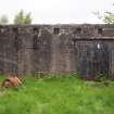
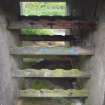
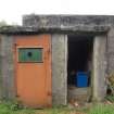
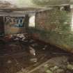
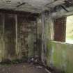
The World War Two command post (NS 75152 69017), which is largely brick-built and also partly buried within an earthen bund, is situated W of the track about 15m from each of the gun-pits. It may have been refurbished for use with the Cold War battery, before the decision was taken to provide a new building at a greater distance from the guns (see below). This earlier command post is rectangular on plan and measures externally 20.2m from NNE to SSW by 7.9m transversely. A concrete terrace on the ESE supports the platforms for the height finder, the spotting telescope and the predictor, behind which is a porch that shelters a flight of steps leading down to the control rooms. These occupy a block attached to the WNW, as well as wings to its NNE and SSW. They are protected by an asphalt covered flat roof of reinforced cast concrete. The block contains two compartments – the plotting room and the space occupied by the retransmission unit, while the wings each contain two further compartments for use as offices or stores. All have been stripped of their fittings, but a larger double doorway on the WNW provides a rear access to the transmission room. This is lit by a single widow that looks out on to the terrace, while the plotting room is lit by two windows facing in the same direction. By contrast, hatches looking out on to the terrace are provided at the ESE end of each wing. Two small shelters are also attached to the end of the NNE wing, one of which contains a narrow flight of steps leading downwards.
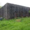
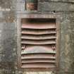
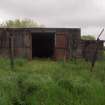
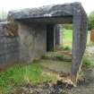
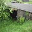
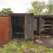
The Cold War engine house (NS 75070 69035), which provided the electricity for the guns and other operational systems, is situated at the end of a grass-grown spur road that leaves the main track about 30m WSW of the enclosure containing the command post and the gun emplacements. Built entirely of reinforced cast concrete, it is almost square on plan, measuring 7.8m from NNW to SSE by 7.5m transversely over walls 3.3m high. The SSE façade is distinguished by locked sheet metal double doors adjacent to the SE corner and five equally-spaced rectangular vents immediately below the flat roof. Five similar vents occur in the same position in the NNW wall and three in the ENE wall, while the WSW side is distinguished not only by three tall rectangular vents with iron louvres located 0.6m above the ground surface, but also by 3 smaller square vents immediately above, but off-centred to their NNW. Three horizontal rows of drilled holes spaced at regular intervals around each side of the building probably held fittings for the attachment of camouflage netting
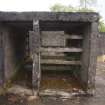
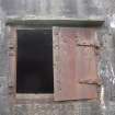
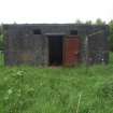
The Cold War command post (NS 75059 68957) is situated 5m NNW of the main track and some 40m WSW of the junction that this makes with the spur road leading to the generator block. It is closely confined within a ruined security fence comparable with that surrounding the World War II command post and gun emplacements. The building itself, which is also of reinforced cast concrete, is rectangular on plan and measures 12.7m from NNW to SSE by 6.7m transversely within walls 0.3m thick and 3m high. The SSE and ENE sides have been peppered by shot. A sheet metal door protected by a projecting cast lintel occupies the centre of the SSE façade, where it is flanked on each side by a rectangular vent immediately below the flat roof. This contrasts with the NNW elevation, where a concrete ramp approaches a central double doorway protected by a cast lintel that still has one of its sheet metal doors in place. In the ENE wall there is a window, again protected by a cast lintel, which was also originally fitted with sheet metal shutters. Only one hangs in place, the other being detached and now propped up against the wall below. Again, two rectangular vents are situated just below the flat roof, while four large metal pipes emerge from the base of the wall and turn down to pass underground. A rectangular inspection pit is also situated against the foot of the wall about 0.3 to the NNW. The opposite elevation on the WSW is plainer, being broken only by a pair of rectangular vents immediately below the flat roof at the NNW end of the building. However, there is a flat-roofed outshot of reinforced cast concrete at the NNW corner comprising two small discrete compartments each of which is entered by a sheet metal door on the WSW. The NNW and SSE elevations have two small vents located below the roof and at the foot of the building respectively, while there is additionally a square window in the centre of the SSE face. The interior of the main building is divided into two compartments, but although both have been stripped of their fittings, low plinths on the floor in the NNW compartment suggests it may have housed the computers.
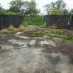
What remains of the camp, occupying an area of about 1ha, is situated about 40m WSW of the Cold War command post, where the concrete foundations of 31 rectangular buildings are at least partly visible S and N of the track (NS 7506868879, NS 75057 68869, NS 75053 68859, NS 75037 68867, NS 75031 68857, NS 75091 68853, NS 75007 68852, NS 75006 68870, NS 75040 68882, NS 75063 68889, NS 75060 68892, NS 75052 68897, NS 75033 68899, NS 75029 68892, NS 75026 68917, NS 75022 68910, NS 75017 68904, NS 75004 68884, NS 75004 68892, NS 75003 68909, NS 74987 68880, NS 74985 68889, NS 74983 68896, NS 74985 68907, NS 74975 68908, NS 75006 68957, NS 75002 68971, NS 75003 69015, NS 75004 69035, NS 75004 69049, NS 75005 69058). Most are grass-grown and have been constructed on level ground, but some on the S are terraced into the SE facing scarp. Their footprints vary from about 4m by 3m transversely to 24m by 5m transversely.
There is no trace of a radar mat, but other features include at least five drain hatches, two of which are located in the centre of the track close to the gun emplacements (NS 75164 69032, NS 75170 69018), while others occur amongst the camp buildings (NS 75041 68919, NS 75033 68879), or in relatively isolated locations (NS 75180 68981).
Visited by HES, Survey and Recording (ATW, AKK) 21 June 2017.

