
Uddingston, Blantyre Farm Road


Anti Aircraft Battery (20th Century)
Site Name Uddingston, Blantyre Farm Road
Classification Anti Aircraft Battery (20th Century)
Alternative Name(s) Gsg1; S1; Clyde Aa Defences; Blantyreferme
Canmore ID 107521
Site Number NS65NE 43
NGR NS 6818 5985
Datum OSGB36 - NGR
Permalink http://canmore.org.uk/site/107521


- Council South Lanarkshire
- Parish Blantyre (Hamilton)
- Former Region Strathclyde
- Former District Hamilton
- Former County Lanarkshire
NS65NE 43 6818 5985
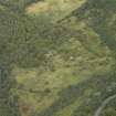
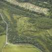
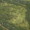
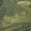
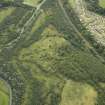
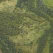
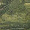
This four gun-emplacement battery is situated immediately E of the main Glasgow-London railway. Consisiting of four emplacements, ammunition lockers, command post and the GL mat (gun laying radar hexagon) to the NE. The accommodation camp was situated adjacent to the B758 public road.
Information from RCAHMS (DE) July 1997
This World War II heavy anti-aircraft battery is situated to the N of the railway line and W of Blantyre Farm Road. Consisting of six gun-emplacements, command post, magazines and a gun store all still extant, a spoil heap is now encroaching on the site and one or two other buildings are partly buried.
The battery was armed with four 4.5-inch guns.
J Guy 2001; NMRS MS 810/11, Part 3, 229-230; Vol.2 (appendix), 23
Two gun emplacements were added later in the Second World War, though the documents in the National Archives (Public Record Office) do not record this. Designated S1 or GSG1 as part of the Clyde Defences, the documents show that it was equipped with four 4.5-inch guns in 1942-43, but by 1945 had been re-equipped with four 3.7-inch guns. In addtion between 1942 and 1943 a Gl (gun-laying) Mk II radar set was in operation.
The battery is visible on an RAF WW II oblique aerial photograph (F309, 3648, flown 6 June 1941), which shows that at this date only four gun-emplacements had been built.
A recent site visit in September 2006 noted that the heavy anti-aircraft battery was still as Mr Guy had noted in 2001.
Visited by RCAHMS (MMD, EL), 5 September 2006
Watching Brief (26 March 2012 - 20 June 2012)
GUARD Archaeology Limited where initially commissioned by South Lanarkshire Council to undertake an archaeological watching brief to clear and survey the site of a WWII anti aircraft battery and ancillary buildings disturbed by vandalism. Phase 1 of this work was undertaken between 26 – 27th of March 2012 to document and detail these features before any further destruction or lasting damage took place. Phase 2 took place between the 16th April – 21st May 2012 during clearance works over the rest of the site and grading and shaping of the surrounding earth around the structures themselves. Final phase 3 was undertaken on the 20th of June 2012 when the second magazine’s roof was being demolished.
Field Visit (16 August 2018)
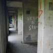
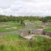
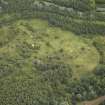
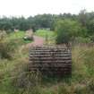
This heavy anti-aircraft battery is situated in the Redlees Urban District Fringe Park, within what remains of a post-war security fence. This fence has been subsumed beneath spoil on the W, but otherwise encloses a carefully landscaped area comprising gravelled tracks and pathways that partly reflect the course of the battery’s original service roads, neatly mown lawns and a scatter of recently planted oak trees. The tracks have been metalled with gravels of different colours, in order to distinguish the service road (dark) from those that are entirely modern (pale). The remains of the battery, itself, comprises five gun emplacements, a command post, two magazines and a gun store, but only fragments can be observed of the camp. It was one of at least 43 such batteries that were constructed to protect the industries in the centre of Glasgow and along the banks of the River Clyde from aerial attack by the Luftwaffe during WWII. However, it was also later one of at least 78 heavy anti-aircraft gun emplacements that were deployed to counter the threat from the Soviet Union during the Cold War c.1950-56 (WO106/5912).
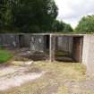
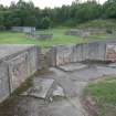
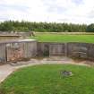
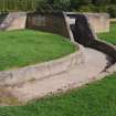
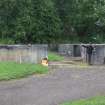
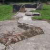
The four original gun-pits (NS 68139 59862, NS 68150 59837, NS 68175 59827, NS 68200 59840) are planned around the circumference of a circle with a radius of 32m pivoted on a NE to SW axis. They can be separated into two pairs, one on the W arc of the circle and one on the SE, but all are of the same overall design and were originally protected by bunds that have now been greatly reduced in height and all but smoothed away. Each is a regular octagon on plan, measuring 13m in diameter within reinforced cast concrete blast walls 0.35m thick and 1.75m high. The S to SE angle in the wall of the SW gun-pit has been strengthened internally with two steel straps. Although a pair of opposed gateways 3.75m wide occupied two of their sides, the W section of the W gun-pit is now subsumed beneath spoil, while the SSW section of the SW gun-pit and the SW section of the S gun-pit have all been demolished. By contrast, the SE gateway of the SE gun-pit has been deliberately stopped-up with a brick wall capped with concrete blocks, within which there is a staggered entrance only 0.67m wide. Although reduced, this still permits access to a kerbed concrete path (similar to that leading from the SSW gate of the S gun-pit), which leads down a slope to the magazine that they both shared. A comparable arrangement originally served the W and SE gun-pits, but this magazine has been subsumed beneath spoil and all that remains is a short length of the kerbed concrete path that led to the service road. The gun-pits were also provided with six open-ended ammunition lockers symmetrically arranged against the inner side of the blast wall. These had flat, bitumen-covered, reinforced cast concrete roofs, raised concrete floors, brick linings, two rows of put-logs supporting four wooden racks and were open at each end. The bottom rack survives in the SW locker of the W gun-pit. Whereas the lockers adjacent to the gateways measure 2.05m long, by 1.5m broad and 1.5m high within an inner concrete wall measuring 0.25m thick, the central lockers measure 2.05m long by 1.35m broad and 1.5m high within an inner wall measuring 0.32m thick. This slight reduction in the volume of the central lockers’ internal space is accounted for by this increase in the wall’s thickness, as this permitted the insertion of a pair of vertical airbricks at each end to reduce the risk of damp – one positioned just below the roofline and the other just above the floor. However, most of the lockers have been destroyed - only five survive in the W gun-pit and only one in the SW gun-pit. Inverted triangular plate-marks on the blast walls between the lockers mark the position of electrical junction boxes. Rectangular drains are situated to either side of the central ammunition lockers at the foot of the blast walls in the W, SW and SE gun-pits - in one instance positioned at the point where their angles change. A similar aperture, only visible in the W and SW gun-pits, is located to one side of the gateways facing the command post. This conveyed the cabling to the guns and the culverts leading up to this opening are visible both in the surface of the service road and crossing towards the hardstanding. In every instance, these are buried beneath a grass-grown earthen capping. All, except the W gun pit, still possess an external shelter attached to their blast walls and incorporated in what remains of their bunds. These are rectangular on plan and measure 5.3m long by 3.12m broad over brick walls 1.85m high. They have flat, overhanging concrete roofs and off-centred doorways, together with a vent centred in the opposite wall just below the roofline. However, their doorways have all been bricked-up. In addition, single side entrances occur in the blast walls on the NE and SW sides of the SW and SE gun pits, respectively. They measure 0.9 wide and may be a later modification. The example in the SE gun pit leads outside to a small compartment, which retains traces of a hemispherical corrugated iron roof and a NW-facing entrance.
A later style of gun-pit (NS 68145 59888) is situated 13.5m N of the W gun-pit. This was one of a pair, as its counterpart (NS 68220 59860) was situated in the same relationship to the SE gun-pit. However, whatever may remain of this is now buried beneath the recent landscaping. The surviving gun-pit is an irregular octagon on plan, measuring 13.6m in diameter within a concrete hollow block-built blast wall 0.23m thick and 1.8m high. This is buttressed at the corners on the exterior and was designed to have only a single gateway, measuring 3.7m wide, with wing walls leading SE to the service road and pointing towards the command post. It was provided with four ammunition lockers, but they have all been demolished. However, they were symmetrically arranged against the inner side of the blast wall and plainly had flat concrete roofs, raised concrete floors and open ends. They were also a little larger than those in the earlier gun-pits, measuring 3.3m long by 1.85m wide within concrete hollow block walls 0.24m thick. The hardstanding at the centre is marked by a grass-grown mound and the duct for the cabling to the gun is visible as far as the entrance. There is also a compartment extending beyond the blast wall immediately S of the E locker and N of the gate, which also once had a flat concrete roof. It measures 1.62m from E to W by 1.4m transversely within hollow block walls 0.24m thick and 1.77m high. Immediately E of the S locker is a narrow entrance leading to another compartment, but this once had a hemispherical corrugated iron roof. It measures internally 3m from E to W by 0.8m within the hollow block walls that are reduced to 0.25m high on the S. Fragments of walling suggest that another similar compartment lay immediately to its W.
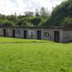
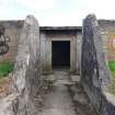
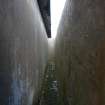
The magazine (NS 68197 59817) associated with the S and SE gun-pits is situated about 13m to their SSE. It is rectangular on plan and measures 11.1m from ENE to WSW by 3.8m transversely within cast concrete walls 0.16m thick and 2.7m high. It has a flat, overhanging concrete roof and its façade is divided into five bays by six narrow, rectangular pilasters. These frame three equally spaced entrances divided by two small rectangular windows with cast concrete sills. Unusually, the windows retain their iron frames. Internally, a passage runs the length of the building immediately behind the façade. This provides access to five compartments, the outermost and central one of which have blocked circular apertures in their roofs. The building is closely protected on all sides by a reinforced cast concrete blast wall measuring 0.3m thick and up to 3m high. It is only breached where approached by the paths from the gun-pits and from the service road.
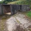
A third magazine (NS 68172 59774) is situated 33m to the SW, at the S corner of the enclosure delimited by the security fence. Slightly sunken below the present ground level, it is also rectangular on plan. However, it is twice the length of the magazine associated with the S and SE gun-pits, measuring 22.5m from NNW to SSE by 3.7m transversely within cast concrete walls 0.11m thick and 2.7m high. It has a flat, overhanging, bitumen covered concrete roof and its façade is divided into ten bays by 11 narrow, rectangular pilasters. These frame six equally spaced entrances, but the spaces between them are plain and lack windows. Internally, a passage runs the length of the building immediately behind the façade. This provides access to ten compartments numbered from NNW to SSE.
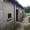
The gun store (NS 68153 59804), which is situated midway between the magazines and about 45m SSW of the command post, is linked to the service road by a lengthy concrete path lacking kerbs. The building is rectangular on plan and measures 7.7m from NNE to SSW by 6.15m transversely within reinforced cast concrete walls 0.35m thick and 2.65m high. Its roof has been removed and the entrance at the N corner of the NNE wall has also been destroyed. In addition, the building’s SW corner has been strengthened externally with two horizontal steel straps. The WNW wall is entirely plain, but the ESE wall features four widows with cast concrete lintels and sills – two that are narrow and rectangular positioned either side of two that are broad and square. The interior contains a single compartment. At the S corner of the SSW wall is a shallow outshot, which retains its flat concrete roof. This is connected to the main entrance by a concrete path outwith a moulded gutter.
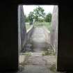
The command post (NS 68174 59853), which has been reduced to its foundations, comprised originally at least four compartments situated 1.5m below and immediately SW of the linked enclosures that contained the spotting telescope, the height finder and the predictor. It measures 14.2m from WNW to ESE by 7.5m transversely. A concrete ramp, approaching from the service road to the SSW, provided access and there may have been another entrance on the NNE. A cable duct runs the length of what may have been the plotting room. Unlike its neighbours, the NW enclosure’s walls remain upstanding and measures 0.35m thick and 1m high. Its central entrance, which faces NE remains intact, but the concrete floor has been destroyed at the centre, where there may have been a triangular plinth or setting, as these still remain in the floors of the two enclosures immediately SE. The plinth in the central enclosure, measuring 1.65m from NE to SW by 1.5m transversely and 0.16m high, is constructed from cement skimmed bricks and has a concrete projection close to its centre measuring 0.16m sq. and 0.05m high. Although the floor in the third enclosure has been despoiled, its roughly triangular setting is defined by a border at least two bricks thick which surrounds a slight hollow. It measures 2.25m from NE to SW and 0.05m deep.
Apart from the apertures in the gun-pits and the moulded drains around some of the buildings with overhanging roofs, little can be observed of the drainage system, although there is a contemporary concrete surround (NS 68146 59848) adjacent to the truncated path leading to the buried magazine and what may be a more recent cover (NS 68165 59848) associated with a culvert emanating from the SW gun-pit.
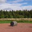
There is no evidence that the two concrete drums (NS 68191 59787, NS 68295 59880) measuring 1m in diameter and 1.1m in length have any connection with the military activity on the site. Their fluted outer surface results from their having been cast within corrugated iron shuttering. One is situated at the centre of a circular area of gravel (NS 68191 59787) about 10m ENE of the long magazine. This is plainly intended to mimic a barrage balloon anchor pad, but the presence of a balloon in association with a heavy anti-aircraft battery would be quite exceptional and the available records offer no support for this.
Most of the camp has been lost beneath spoil, but traces of three concrete building platforms (centred NS 68240 59767) are situated in scrub SE of the security fence.
Visited by HES (ATW, AGCH) 16 August 2018.

