|
Manuscripts |
MS 725/156 |
Records from the Department of Archaeology, University of Glasgow, Glasgow, Scotland |
Report (GUARD 498) of an archaeological evaluation of the Antonine Wall, Ballaig Avenue, Bearsden, Glasgow, on behalf of Mr Ronald Ross. |
4/9/1997 |
Item Level |
|
|
Manuscripts |
MS 726/194 |
Records of CFA Archaeology Ltd, archaeologists, Musselburgh, East Lothian, Scotland |
Proposed underground cable Kilbowie to Windyhill Archaeological Excavation and watching brief at Cleddans Road, Hardgate, West Dunbartonshire. Data Structure Report 611, by Kirsty Cameron, CFA Archaeology Ltd, November 2000
|
11/2000 |
Item Level |
|
|
Manuscripts |
MS 726/187 |
Records of CFA Archaeology Ltd, archaeologists, Musselburgh, East Lothian, Scotland |
Data Structure Report: Proposed 132kV underground cable - Kilbowie to Windyhill. Archaeological evaluation of the Antonine Wall at Cleddans Road, Hardgate, West Dunbartonshire. |
5/2000 |
Item Level |
|
|
Photographs and Off-line Digital Images |
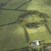
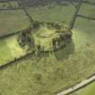
E 43169 |
RCAHMS Aerial Photography |
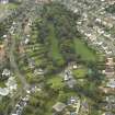
Oblique aerial view centred on the remains of the Roman fort and the course of the Antonine Wall, taken from the W. |
28/7/2003 |
Item Level |
|
|
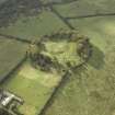
Photographs and Off-line Digital Images |
E 43170 |
RCAHMS Aerial Photography |
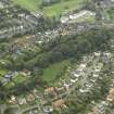
Oblique aerial view centred on the remains of the Roman fort and the course of the Antonine Wall, taken from the WSW. |
28/7/2003 |
Item Level |
|
|
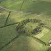
Photographs and Off-line Digital Images |
E 43171 |
RCAHMS Aerial Photography |
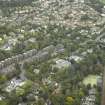
Oblique aerial view centred on the remains of the Roman fort and the course of the Antonine Wall, taken from the SW. |
28/7/2003 |
Item Level |
|
|
Manuscripts |
MS 2702 |
Records of FIRAT Archaeological Services, archaeologists, Helensburgh, West Dunbartonshire, Scotland |
Report - Watching brief of new drainage works and underpinning of foundations for New Kilpatrick Parish Church, 2003. |
7/11/2002 |
Item Level |
|
|
Manuscripts |
MS 2703 |
|
Report - Archaeological excavations on the line of the Antonine Wall at Peel Glen Road, 1982. |
6/1982 |
Item Level |
|
|
Manuscripts |
MS 2705 |
|
Report - Trial trenching established outlines of Roman fortlet along Antonine Wall at Cleddans, 1980. |
1980 |
Item Level |
|
|
Photographs and Off-line Digital Images |
DC 47351/17 |
Records of the Ordnance Survey, Southampton, Hampshire, England |
Ordnance Survey 6-inch to the mile Provisional Edition , Revision of 1914 partly revised in 1933-34 with additions in 1938.
Additional annotations by Ordnance Survey for the Antonine Wall map covering the parish of Bearsden. |
c. 1938 |
Item Level |
|
|
Photographs and Off-line Digital Images |
DC 47351/18 |
Records of the Ordnance Survey, Southampton, Hampshire, England |
Ordnance Survey 6-inch to the mile Provisional Edition , Revision of 1914 with additions in 1938.
Additional annotations by Ordnance Survey for the Antonine Wall map covering the parish of New |Kilpatrick with Castle Hill. |
c. 1938 |
Item Level |
|
 |
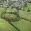
On-line Digital Images |
DP 018852 |
RCAHMS Aerial Photography Digital |
Oblique aerial view centred on the course of the Antonine Wall and the site of the adjoining Roman fort and possible Roman fortlet, taken from the ESE. |
10/11/2006 |
Item Level |
|
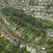 |
On-line Digital Images |
DP 018853 |
RCAHMS Aerial Photography Digital |
Oblique aerial view centred on the course of the Antonine Wall with the housing adjacent, taken from the SE. |
10/11/2006 |
Item Level |
|
 |
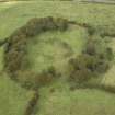
On-line Digital Images |
DP 020953 |
RCAHMS Aerial Photography Digital |
Oblique aerial view centred on the course of the Antonine Wall and the site of the adjoining Roman fort and possible Roman fortlet, taken from the SSE. |
8/9/2006 |
Item Level |
|
 |
On-line Digital Images |
DP 020954 |
RCAHMS Aerial Photography Digital |
Oblique aerial view centred on the course of the Antonine Wall and the site of the adjoining Roman fort and possible Roman fortlet, taken from the ENE. |
8/9/2006 |
Item Level |
|
 |
On-line Digital Images |
DP 020955 |
RCAHMS Aerial Photography Digital |
Oblique aerial view centred on the course of the Antonine Wall and the site of the adjoining Roman fort and possible Roman fortlet, taken from the NE. |
8/9/2006 |
Item Level |
|
 |
On-line Digital Images |
DP 020956 |
RCAHMS Aerial Photography Digital |
Oblique aerial view centred on the course of the Antonine Wall and the site of the adjoining Roman fort and possible Roman fortlet, taken from the W. |
8/9/2006 |
Item Level |
|
 |
On-line Digital Images |
DP 020957 |
RCAHMS Aerial Photography Digital |
Oblique aerial view centred on the course of the Antonine Wall and the site of the adjoining Roman fort and possible Roman fortlet, taken from the SSW. |
8/9/2006 |
Item Level |
|
 |
On-line Digital Images |
DP 020958 |
RCAHMS Aerial Photography Digital |
ESE oblique aerial view of the course of the Antonine Wall,Castlehill Roman Fort and possible fortlet. |
8/9/2006 |
Item Level |
|
 |
On-line Digital Images |
DP 020959 |
RCAHMS Aerial Photography Digital |
Oblique aerial view centred on the course of the Antonine Wall with the housing adjacent, taken from the ESE. |
8/9/2006 |
Item Level |
|
 |
On-line Digital Images |
DP 020960 |
RCAHMS Aerial Photography Digital |
NE oblique aerial view of the course of the Antonine Wall at Bearsden. |
8/9/2006 |
Item Level |
|
 |
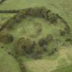
On-line Digital Images |
DP 020963 |
RCAHMS Aerial Photography Digital |
General oblique aerial view centred on the site of the Roman fort and the excavated Roman bath-house with the course of the Antonine Wall adjacent, taken from the SW. |
8/9/2006 |
Item Level |
|
 |
Digital Files (Non-image) |
WP 000102 |
Records of GSB Prospection, archaeologists, Bradford, Yorkshire, England |
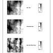
Geophysical Survey Data: Area 1 Resistance Data (Greyscales) |
c. 2006 |
Item Level |
|
 |
Digital Files (Non-image) |
WP 000103 |
Records of GSB Prospection, archaeologists, Bradford, Yorkshire, England |
Geophysical Survey Data: Area 1 Magnetic Data (XY trace plots and greyscale). |
c. 2006 |
Item Level |
|


