
Eigg, Galmisdale


Field System (Medieval) - (18th Century), Township (Medieval) - (18th Century)
Site Name Eigg, Galmisdale
Classification Field System (Medieval) - (18th Century), Township (Medieval) - (18th Century)
Canmore ID 106176
Site Number NM48SE 27
NGR NM 4739 8401
Datum OSGB36 - NGR
Permalink http://canmore.org.uk/site/106176


- Council Highland
- Parish Small Isles
- Former Region Highland
- Former District Lochaber
- Former County Inverness-shire
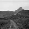
Galmisdale Former crofting community in the lee of the Sgurr, its old houses pulled down in 1897 when crofters were relocated to the island's north end to make way for the new lodge. Plans by the British Fisheries Society to develop a fishing village here in 1788 fell through, and instead a small, injudiciously-sited dock was built with statute labour by Clanranald in 1790, principally to service his kelp industry. A small castellated structure on the present pier, built 1930 as the estate office, assumed the role of gate lodge for arriving and departing visitors.
Taken from "Western Seaboard: An Illustrated Architectural Guide", by Mary Miers, 2008. Published by the Rutland Press http://www.rias.org.uk

NM48SE 30 centred on 474 840
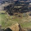
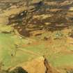
A crofting township, comprising fifteen roofed buildings and two unroofed structures, and a field-system is depicted on the 1st edition of the OS 6-inch map (Inverness-shire Island of Eigg 1880, sheet lxxiii). Three roofed buildings and the field-system are shown on the current edition of the OS 1:10000 map (1976).
Information from RCAHMS (AKK) 9 December 1996.
Located south west of NM48SE 28, Galmisdale, Old Inn
Field Visit (2001 - 2002)
To the SW of Galmisdale House there are the remains of a township comprising at least eleven buildings and four small enclosures. Most of the buildings are clustered together on the S side of the modern track at NM 47387 84022, but there are four outliers; two (EIGG01 246-7) stand 25m apart some 150m W of the main group, a third (EIGG01 245) stands on its own 150m to the SW and the fourth outlier (EIOGG01 493) stands 100m to the E. Several of the buildings have been severely robbed, and are now reduced to rectangular stances or short stretches of walling; in the eight examples where measurements can be taken the buildings range from 6m to 10.4m in length by 3m to 3.7m in breadth within rubble walls standing up to 0.4m in height.
William Bald's 1806 map of Eigg depicts a cluster of buildings in this area, grouped around Galmisdale House. It is one of two settlements shown on the farm of Galmisdale; the other, to the NE, is described under NM48SE XX. The 1st edition of the OS 6-inch map (Inverness-shire, Island of Eigg 1880, sheet lxxiii) depicts three buildings, two roofed and one unroofed, which correspond with three of the ruined structures in the main group described above. The 2nd edition of the OS map (1903) depicts one roofed and one partly-roofed building here. Neither OS map shows any of the outlying buildings noted above. Finally, there is an associated field system lying to the SE of the two townships.
(EIGG01 243-7, 264, 492-3)
Visited by RCAHMS (MFTR) 15 May 2001 and (AGCH) 11 October 2002
Note (23 October 2009)
The evacuation of the crofters from Galmisdale to Cuagach by Robert Thomson in the 1890s is described by Dressler (1998, 99-100).
Information from RCAHMS (LMcC) 23 October 2009
C Dressler 1998

